25 Hueco Tanks State Historic Site
A day hike through the jumbled rock masses of Hueco Tanks, past ancient pictographs and rock-climbing areas.
Distance: 4.0-mile loop, including side trip to North Mountain summit
Approximate hiking time: 2 hours
Elevation: 4,510 to 4,800 feet
Trail surface: Dirt path, solid bedrock
Best season: Fall through spring
Water availability: Campground and visitor center near trailhead
Land status: State park
Nearest town: El Paso
Fees and permits: Park entrance fee; permit required for hiking
Maps: USGS Hueco Tanks; Hueco Tanks State Historic Site map
Trail contacts: Hueco Tanks State Historic Site, 6900 Hueco Tanks Road No. 1, El Paso 79938; (915) 857-1135
Finding the trailhead: Drive east of El Paso on US 62-180 for about 30 miles to the turnoff to RM 2775 on the left. Follow RM 2775 north about 8 miles to the Hueco Tanks State Historic Site headquarters. The entrance road comes to a junction just past park headquarters. Park in the lot across the junction.
The Hike
Three large masses of rock form what is known as Hueco Tanks. The igneous rock, a syenite porphyry, intruded into layers of older sedimentary rock. Over time, the limestone eroded away, leaving piles of rock 300 feet high as islands in the desert. The park’s name comes from the Spanish word for hollow, referring to the depressions—often water filled—in the rock.
The park lies in dry Chihuahuan Desert and receives only about 8 inches of rain per year. However, the runoff from the bare rock concentrates in hollows, canyons, and cracks in the rocky islands. The coarse igneous soil in these places holds the moisture, allowing trees such as the Arizona oak and the one-seed juniper to grow in the dry climate.
Man first visited Hueco Tanks as far back as 10,000 years ago. Indians continued to utilize the area, probably drawn to the water trapped in the rock depressions. The various groups of people left pictographs scattered throughout what is now the park.
The park is very popular. Vandalism of the park pictographs has forced park management to limit visitation and restrict unguided access to some areas. Only limited numbers of people are allowed entrance at one time; advance reservations are recommended. You must obtain a permit before hiking at the park. Self-guided hikes can only be done on and around North Mountain. A guided tour is required to do the entire hike described here.
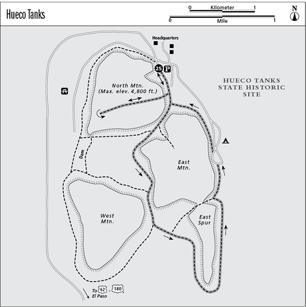
The trail starts at the parking lot at the ruins of the old Butterfield Overland Mail Station. Like the Indians, the stage line was attracted by the availability of water. The area near the stage station is crisscrossed with both official and unofficial trails. You will need to keep an eye on the map and your location in relation to the three small mountains. Do this and you are unlikely to get lost.
Hike south, along the east side of North Mountain, keeping an eye on the rock slopes of North Mountain to your right. Head up to the steel railings on the rock when you see them. Follow the marked route as far as it goes, and then pick your way through the rocks and cliffs to the summit. Enjoy the view. West Mountain (to the south) is higher but harder to climb. Give in to temptation and scramble up and down rocks until your muscles ache. Hueco Tanks is a rock climbers’ paradise; top climbers from all over the United States descend on the park, especially in winter.
Retrace your route back down, or bushwhack a different route. Continue south through the gap between North and East Mountains. Look for pictographs on the wall of East Mountain as you hike through the gap. Walk along the side of the East Mountain through the small valley in the middle of the three mountains. Continue south through the gap between East and West Mountains and then turn left and loop around the south end of East Mountain and the East Spur to the campground. Follow the road back north from the campground to the trailhead.
Don’t worry about following the route of the suggested hike exactly. It’s hard to get lost—it’s a small park. You’ll probably be tempted to spend time climbing up and down the rocks of North Mountain. Check with the park about permits and releases before climbing. Pictographs are scattered here and there all over the park. Keep a sharp eye out for them, especially in overhangs, caves, and cracks. Don’t disturb them or even touch them. They are very old and fragile.
Miles and Directions
0.0Start at the trailhead just past park headquarters. Follow railings up onto North Mountain.
0.5Summit of North Mountain. Retrace your route to bottom.
1.0Bottom of North Mountain. Walk south through the gap between North and East Mountains. Follow base of East Mountain south to the gap between it and West Mountain.
1.75Gap between East and West Mountains. Go southeast to the southernmost point of East Mountain, the East Spur.
2.5Southern tip of East Spur. Turn north and follow the trail along the base of East Spur and East Mountain to the campground.
3.25Campground. Follow the road or the trail back to the trailhead.
4.0Arrive back at the trailhead.