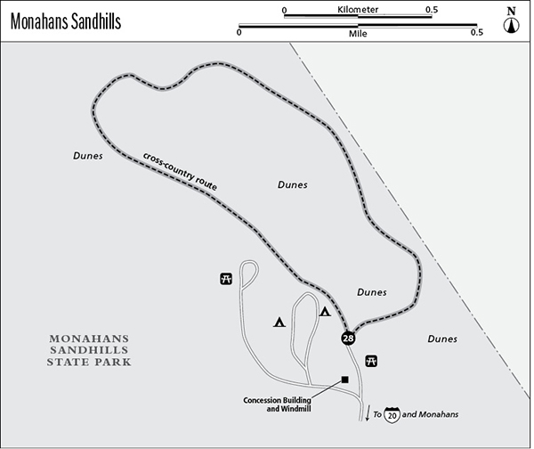
28 Monahans Sandhills State Park
A day hike through a field of sand dunes.
Distance: 2.0-mile undefined loop
Approximate hiking time: 1 to 2 hours
Elevation: 2,730 to 2,780 feet
Trail surface: Cross-country through sand dunes
Best season: Fall through spring
Water availability: Trailhead
Land status: State park
Nearest town: Monahans
Fees and permits: Park entrance fee
Maps: USGS Cowden Place; Monahans Sandhills State Park map
Trail contacts: Monahans Sandhills State Park, Box 1738, Monahans 79756; (432) 943-2092
Finding the trailhead: From Monahans drive northeast on I-20 about 6 miles to the exit for Monahans Sandhills State Park. Drive into the park on Park Road 41. Ignore the right-hand turn to the first picnic area and turn right into the second picnic area at the concession building and windmill. Park in the large lot at the picnic area.
The Hike
The dunes in the state park are only part of a massive dune field that stretches for over 200 miles, from south of Monahans to southeastern New Mexico. In most areas the dunes are stabilized by vegetation, but the park contains a large area of active, shifting dunes. Although the park appears to be dry desert, just beneath the surface lies a very shallow freshwater aquifer. With adequate rainfall, the water table is often high enough to form pools in low areas between the dunes. The water attracted man as far back as 12,000 years ago. Settlers and travelers avoided the area for many years because of the difficulty of traveling in sand. However, in the 1880s the Texas and Pacific Railroad laid tracks through the area and selected Monahans as a stop because of the availability of water. Oil was discovered in the area in the 1920s, leading to development over much of the large Permian Basin.
This hike doesn’t follow a formal route, and the 2.0-mile length is arbitrary. Head out of the north side of the parking lot into the dunes. Go a mile or so and then head back to the parking lot in a big loop. Two miles of hiking in sand is farther than you think. Here and there the dunes are stabilized by a miniature forest of oaks. These oaks are fully mature, even though they rarely exceed 4 feet in height. Their acorns are surprisingly large for such a small tree.
If you are good at route-finding, hike as far out into the dunes as you desire. The windmill at the concession building will help keep you from getting lost if you don’t range too far. Be sure to take a compass if you get out of sight of the windmill. Dunes can also be reached from the other picnic areas. The dunes are hot in summer and can be windy in spring.
Miles and Directions
0.0Start at the trailhead at the picnic area. Hike an arbitrary 2.0-mile loop out into the dunes and back.
2.0Arrive back at the trailhead at picnic area.