34 Colorado Bend State Park
A day hike through typical oak-juniper Hill Country.
Distance: 4.1-mile loop
Approximate hiking time: 2 hours
Elevation: 1,320 to 1,425 feet
Trail surface: Old dirt road and dirt path
Best season: Fall through spring
Water availability: None
Land status: State park
Nearest town: Bend
Fees and permits: Park entrance fee
Maps: USGS Bend and Gorman Falls; Colorado Bend State Park map
Trail contacts: Colorado Bend State Park, P.O. Box 118, Bend 76824; (325) 628-3240
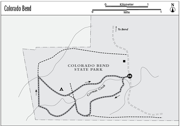
Finding the trailhead: From Llano drive north on TX 16 about 17 miles to Cherokee. Turn right onto RM 501 and go about 16 miles to the junction with FM 580. Go right on FM 580 about 1.3 miles to the village of Bend. Continue straight onto a gravel road in the middle of town, rather than making the sharp turn left on FM 580 over the Colorado River bridge. Signs for Colorado Bend State Park mark the start of the gravel road. Follow the gravel road into the park, following state park signs at junctions. The marked trailhead is on the right at about 5.1 miles. The gravel road is easily passable by any vehicle.
The Hike
Colorado Bend State Park is a relatively undeveloped park with only modest infrastructure. Roads are still unpaved and the formal campground has only tables and composting toilets. However, if you like quiet and solitude, this park is for you. The park lies on a bend of the Colorado River at the very upper end of Lake Buchanan. Boats from the lake can usually navigate at least part way upstream through the park. A narrow, wooded floodplain lines the river, and then steep bluffs rise up into gently rolling uplands.
This hike winds through open upland terrain dotted here and there with clumps of oak and juniper. The lack of recent grazing has led to thick, lush grassland, similar to what once covered much of the TX Hill Country. For the most part the trail follows old, mostly overgrown ranch roads. The old road starts west from the parking area and reaches a fork, marked by a rock cairn and small blue trail markers, in approximately 100 yards. Go left and wind through open Hill Country for about 1.2 miles to another junction. Go right. The left fork heads back to other trails closer to the river.
The next fork in 0.3 mile, another old road, cuts sharply back to the left. Rock cairns mark the turnoff. Take the left fork. You’ll know that you are on the right route when you pass a steel tank on the left in about 0.25 mile and a dirt stock pond in about 0.5 mile. At a total distance of about 2.7 miles from the trailhead you may or may not see a faint unmarked road cutting back to the left. Ignore it and continue on about 50 yards to the proper junction. Turn right at the obvious T-shaped junction. By going left, you can lengthen the loop by about 0.4 mile. (See the map.)
The trail soon passes the marked primitive camping area and a windmill on the left. The windmill tank was full of water when I hiked this trail, but I wouldn’t count on it without inquiring before your hike. On this short a walk I would carry water rather than purifying it.
Just past the windmill lies another set of primitive camping area signs. Look at the large mesquite tree by the signs for the blue-and-yellow plastic trail markers. Turn left off the old road and follow the small blue triangles that point the way. This leg of the hike can be hard to follow, since it’s little used. Look closely and follow the blue markers nailed to stumps and trees. Frequent rock cairns also help with route-finding. The trail is most easily lost when it turns, so look all around for the markers. If you lose the trail, retrace your route and use the map to follow the more obvious fork back to the trailhead.
The route becomes clearer after a while as it joins a faint old road. The road leads straight back to the trailhead, passing the first fork of the loop on the right just before the parking area.
Mountain bikers also use this trail. Don’t miss the other hike in this park, including the guided walks to the spectacular travertine cascades of Gorman Falls and the dark, winding tunnel of Gorman Cave.
Miles and Directions
0.0Start at the trailhead on the park road. Go left at junction that comes up very quickly (about 100 yards).
1.2Trail junction. Go right.
1.5Trail junction. Go left.
2.7Trail junction. Go right.
3.1Primitive camping area.
3.2Trail junction. Go left.
4.1Arrive back at the trailhead.