
Bald cypresses line Cibolo Creek in the Texas Hill Country.
40 Cibolo Creek
A day hike along a cypress-lined Hill Country stream, through a marsh, past dinosaur tracks, and across a meadow.
Distance: 2.8-mile loop, including side trip
Approximate hiking time: 1.5 to 2 hours
Elevation: 1,350 to 1,380 feet
Trail surface: Dirt trail and boardwalk
Best season: Fall through spring
Water availability: Trailhead
Land status: City park
Nearest town: Boerne
Fees and permits: None, but donations appreciated
Maps: USGS Boerne; Cibolo Nature Center brochure and map
Trail contacts: Cibolo Nature Center, P.O. Box 9, Boerne 78006; (830) 249-4616
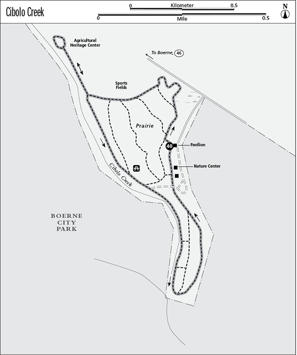
Finding the trailhead: From the intersection of TX 46 and US 87 in the center of Boerne, go east on TX 46 about 1 mile to a paved turnoff on the right. Signs indicate the city park and Cibolo Nature Center. Drive 0.4 mile to a fork and go right again. Continue 0.2 mile and park at the pavilion on the right.
The Hike
The Cibolo Nature Center is an idyllic one-hundred-acre retreat hidden away in a corner of the Boerne City Park. A short, easy trail network winds through a small area of native prairie, a marsh, and a cypress-lined creek. The hike makes an easy escape from the increasing urban chaos of Boerne, once a quiet Hill Country town and now an exploding suburb of San Antonio.
The entire trail network is about 3.5 miles long. This hike covers much of it by making a loop along the outer perimeter of trails. You’ll go right at every junction to stay on the route.
The trail starts right behind the children’s pavilion at a replica of an impressive dinosaur trackway discovered after a 1997 flood exposed them in the Boerne Lake spillway. The concrete replica was molded from the original tracks and looks very authentic. The tracks were made millions of years ago by a large carnivore, probably an acrocanthosaurus.
Bald cypresses line Cibolo Creek in the Texas Hill Country.
From the trackway, the trail drops down into the meadow behind the pavilion. Much of the first part of the hike is a mowed path through the tall prairie grass. At the fork below the pavilion, go right, along the trail heading toward the marsh. Go right again very soon, toward the marsh. Go right again at the third junction just as you reach the marsh. A boardwalk circles through the wet area. At the back side of the marsh, the trail touches the edge of the sports fields adjoining the nature center. At the next five junctions, go right and stay along the edge between the nature center prairie and the sports fields.
The fifth junction will take you upstream along Cibolo Creek through the mowed edge of the sports fields to the Agricultural Heritage Center. At the agricultural center, turn around and retrace your route back to the fifth junction. Go right at that junction and follow the trail downstream along the creek. Go right at the next junction and at the picnic area, staying with the creek.
The trail becomes increasingly scenic as it follows the stream, lined with large bald cypresses and some low stone bluffs. Ignore the two sets of steps climbing the bluff to the left and stay along the creek to the park boundary at a large fence crossing the creek. At the fence the trail climbs up the left bank and loops back upstream along the top of the stream bank along either of two trails. The two trails soon merge and continue back along the wooded bluff past some picnic tables to the nature center buildings. Stay on the bluff by the buildings and pass the two trails that drop back down to Spring Creek. After passing the nature center buildings, the trail reaches the pavilion.
The park is small and the trail relatively short, but Cibolo Creek is a very scenic, tranquil spot in the Hill Country. The nature center recently acquired about sixty acres across Cibolo Creek from the nature center, the historic Herff/Rozelle Farm. This may allow additional trails to be built in the future and will provide a buffer against development for the existing property.
Miles and Directions
0.0Start at the trailhead at the pavilion and dinosaur tracks.
0.05Junction. Go right.
0.1Junction. Go right.
0.2Junction. Go right onto boardwalk.
0.4Junction. Go right.
0.55Junction. Go right.
0.65Junction. Go right.
0.75Junction. Go right.
0.85Junction. Go right toward Agricultural Heritage Center.
1.1Agricultural Heritage Center. Retrace route to last junction.
1.35Junction. Go right along creek.
1.7Junction. Go right along creek.
1.8Junction. Go right along creek through picnic area.
2.0Junction. Go right along creek.
2.1Junction. Go right along creek.
2.2Fence. Climb up from creek to left.
2.25Junction. Go right.
2.45Junction. Go right.
2.55Picnic area. Cross dirt road.
2.7Junction at nature center buildings. Go right, by buildings.
2.75Junction at nature center buildings. Go right, toward pavilion.
2.8Arrive back at the trailhead.