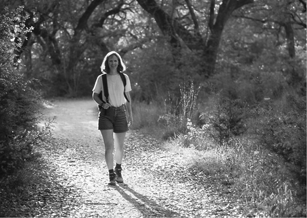
A hiker enjoys the trail along Barton Creek.
42 Barton Creek
A day hike through a surprisingly wild and rugged area within the city of Austin with seasonal waterfalls and rock-climbing areas.
Distance: 15.0 miles out and back
Elevation: 460 to 880 feet
Approximate hiking time: 5 to 7 hours
Trail surface: Dirt path
Best season: Fall through spring
Water availability: Trailhead (Zilker Park)
Land status: City of Austin
Nearest town: Austin
Fees and permits: No fees or permits required
Maps: USGS Austin West and Oak Hill; City of Austin Barton Creek Greenbelt map
Trail contacts: Austin Parks and Recreation Department, 200 South Lamar, Austin 78704; (512) 974-2000
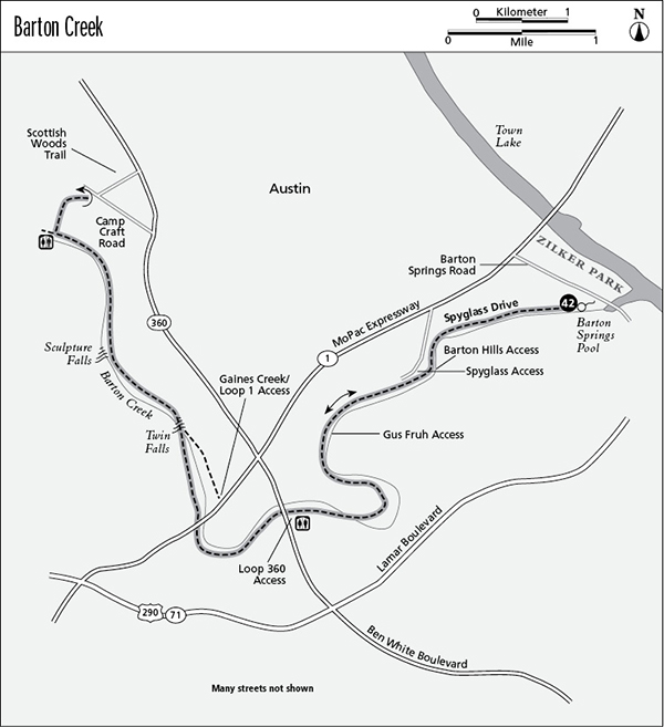
Finding the trailhead: The trail winds through West Austin and has multiple trailheads, making hikes of various lengths possible. One of the easiest to find (and the one described as the starting point for this hike) lies in Zilker Park. Zilker Park lies on the south side of Lady Bird Lake (Town Lake) in the center of the city on Barton Springs Road, between South First Street and Texas Loop 1 (informally known as MoPac). Follow the signs in Zilker Park to Barton Springs Pool. Finding a spot to park can be difficult on summer weekends.
The Hike
In spring and early summer Barton Creek will be a clear running stream, bubbling over cascades into deep pools. Some years, if rains are heavy enough, tubers and canoeists can run the creek. The lower part of the creek is usually dry the rest of the year. The winding canyon follows a course from its confluence with Town Lake at Zilker Park far southwest into the Hill Country. The city of Austin acquired much of the land adjoining the creek and protected it from development. The trail system runs about 7.5 miles upstream from Zilker Park.
The trail along the Barton Creek Greenbelt is one of several that follow creeks in Austin. The Barton Creek Trail is the longest and least developed. Not only does it offer hiking and seasonal boating, several cliffs along the trail attract rock climbers.
From the large spring-fed swimming pool in Barton Creek, walk upstream to the trailhead just southwest of the pool area. Initially the trail passes through woods along the north side of the creek. On the cliffs above, perch expensive houses. The trail is very heavily used, especially on warm weekends. Many side trails and parallel trails have been worn, but the trail follows the creek all the way upstream. The trail crosses the creek several times along its 7.5-mile path. After heavy rains it can be difficult to cross, and occasionally even dangerous.
A hiker enjoys the trail along Barton Creek.
At about 1.25 miles the side trail to the Barton Hills access is on the left, followed by the Spyglass access on the right. As you progress, the terrain gets wilder, sometimes making the city seem nonexistent. The trail passes through lush woods, dominated by oaks, cedar elms, sycamores, and juniper. At a little over 2.0 miles, the Gus Fruh access trail goes to the left. At about 3.5 miles the trail passes the Texas Loop 360 access trail on the left. There is a restroom at the TX Loop 360 trailhead. This access point is easily found on the north side of TX Loop 360 between Texas Loop 1 and Lamar Boulevard.
The trail passes under the high TX Loop 1 (MoPac) bridge a short distance past the TX Loop 360 bridge. At about 6.0 miles, after the trail has become a small dirt road, at least a small amount of water usually appears in the creek, even in the dry season. Two cascades, Twin Falls at 4.75 miles and Sculpture Falls at 6.0 miles, form great swimming holes. At about 7.0 miles the canyon widens into a broad parklike area with a restroom. The trail continues a short distance upstream on the right side before ending. The trail climbs up to the north out of the canyon (the only steep part of the hike) to the upper access point in the Woods of Westlake subdivision. The marked trail hits the subdivision near the intersection of Camp Craft Road and Scottish Woods Trail.
This is a beautiful hike, even if it lies in a large city. Ideally hikers should set up a car shuttle and cut the round-trip length in half. Many mountain bikers use the trail, so be alert for the occasional reckless rider. The main trail is described here, but parallel trails sometimes follow the other bank of the creek. With its city location and heavy use, the trail is not designed for camping. Use care crossing the creek if it’s running high. Floods are not uncommon in spring. In summer, if you set up a car shuttle, start your hike at the top and jump into the enormous Barton Springs Pool at the end to cool off.
Miles and Directions
0.0Start at the trailhead in Zilker Park at Barton Springs Pool.
1.25Junctions with Barton Hills and Spyglass access trails.
3.5Junction with TX Loop 360 access trail and TX Loop 360 bridge.
4.75Twin Falls and junction with Gaines Creek/TX Loop 1 access trail.
6.0Sculpture Falls.
7.25Trail leaves creek bottom.
7.5Arrive at the upper trailhead in Woods of Westlake subdivision. Retrace your steps.
15.0Arrive back at the Zilker Park trailhead.