Because the U.S. government owns the shores of Lake Georgetown, they’re likely to remain in their natural state.
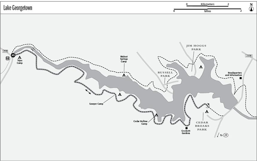
45 Lake Georgetown
A long day hike or overnight backpack along the surprisingly wild shores of Lake Georgetown.
Distance: 22.0 miles out and back (11.0-mile shuttle)
Approximate hiking time: 2 days for overnight trip (5 to 6 hours with car shuttle)
Elevation: 790 to 950 feet
Trail surface: Dirt path
Best season: Fall through spring
Water availability: Tejas Park (trailhead), Cedar Breaks Park, Crockett Gardens Spring, Lake Georgetown
Land status: U.S. Army Corps of Engineers
Nearest town: Georgetown
Fees and permits: Fee to enter Cedar Breaks Park if hike done as shuttle
Maps: USGS Georgetown and Leander NE; U.S. Army Corps of Engineers Good Water Trail map
Trail contacts: U.S. Army Corps of Engineers, Lake Georgetown Project Office, 500 Lake Overlook Drive, Georgetown 78628; (512) 930-5253
Finding the trailhead: From I-35 take exit 261A if going north or exit 262 if going south. Drive west on FM 2338 for 6.5 miles to the junction with FM 3405. Go left and take FM 3405 west for 5.7 miles. Go left on County Road 258 for 1.5 miles to Tejas Park on the left, just after crossing the North San Gabriel River. Park at the restrooms. The trail is right behind the restrooms, on the riverbank.
The Hike
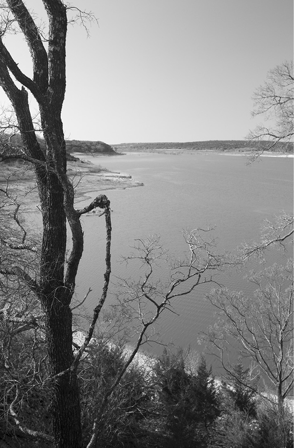
The North Fork of the San Gabriel River was dammed above Georgetown in 1979 to control flooding and provide water to Georgetown, Round Rock, and other cities. The parks and recreational facilities opened in 1981. Unlike most other Texas lakes, the Corps of Engineers owns the land surrounding the lake, so most of it is undeveloped and wild. Many Texas lakes are lined with development, making this one a welcome change.
The Good Water Trail, also called the San Gabriel River Trail—especially the trail below the dam—completely encircles the lake for a total length of 26.0 miles. To complete the loop, the trail crosses the dam at the east end of the lake. For this hike I selected the most wild and scenic section of the trail, the 11.0-mile south section between Tejas and Cedar Breaks Parks. Mountain bikes and horses are not allowed on this section.
The easiest way to do this hike is with a car shuttle, but there are two primitive camps along the way that would make for a pleasant backpacking trip. Although the net elevation change is small, the trail has many ups and downs as it crosses small canyons that feed into the lake. In addition, much of the trail is quite rocky, so the hike is more strenuous than the elevation change and distance would seem to indicate.
From behind the Tejas Park restrooms, take the trail downstream along the river to the right. For the first 0.75 mile the trail is easy and flat as it follows a shaded route along the river. It then climbs steeply up about 20 feet to a higher floodplain bench above the river. The trail soon passes an abandoned low-water bridge over the river below the trail to the left. The bridge provides an opportunity to cross the river to the north side of the Good Water Trail and offers a short loop hike back to the trailhead.
Soon after passing the bridge, the trail hits a bigger, wider trail (an old dirt road) at a junction below some wooded bluffs. Go left. If you are traveling from the east, turn right onto the smaller trail right after passing two signposts with a missing sign. In general, except when crossing some of the side canyons, the trail never gets very far from the river and lake. Mile markers give mileages on most of the route. The Corps of Engineers map is not very good, and the topo maps do not show the trail. In fact, the USGS Leander NE quad is so old that it doesn’t even show the lake. However, the route is generally easy to follow.
Because the U.S. government owns the shores of Lake Georgetown, they’re likely to remain in their natural state.
At about 1.5 miles the trail leaves the floodplain and climbs partway up a big bluff that squeezes close to the river. Large trees here offer welcome shade. Depending on lake levels, the upper end of the lake will sometimes extend up into this area. Mile Marker 9 (MM 9) is on top of the bluff. Considering the nearness of Georgetown and the Austin metropolitan area, the area is surprisingly wild and empty. Only a few scattered houses are visible far across the river on bluffs outside the lake property.
The trail drops off the bluff and traverses a long stretch of grassy, open floodplain at the base of the bluffs. The trail crosses a large tributary creek at MM 8 and continues on the floodplain. A lot of fossils cover the ground here. The lake is usually visible far downstream. At the second large tributary, Sycamore Hollow, the trail follows the small creek upstream a short distance before crossing it and climbing steeply up the far bluff through a juniper thicket. On top of the bluff lies MM 7, with good lake and river views. The trail surface gets rockier and little rough. The trail descends from the bluff into Sawyer Hollow, another tributary. One of the two primitive camps, Sawyer Camp, is here on the left.
The trail climbs up onto another bluff with occasional lake views after Sawyer Hollow. The lake really starts to widen here, so boats become more common in good weather. MM 6 lies on top of this bluff. The trail soon drops down yet again, this time into Hogg Hollow. In rapid succession the trail crosses a black plastic pipe, a dirt road, and then the dam of the tributary’s pond.
After crossing the pond, the trail climbs back up again, partway down and across a small ravine, and back up again. MM 5 lies on this bluff. Just past MM 5 go left at an unmarked fork. The right fork just goes up to some houses beyond the lake property. Pass Cedar Hollow Camp, the second primitive camp, on the left as you drop down to the fifth major tributary with a seasonal stream. The trail follows Cedar Hollow about 0.25 mile upstream before crossing the creek and climbing back up onto a bluff and turning back toward the lake. MM 4 is passed on the bluff.
The trail stays on the bluff top for a while, with good lake views. Just before MM 3 the trail crosses two deep, narrow ravines on footbridges right near the lake property boundary. The trail reaches Crockett Gardens Spring and Falls about 0.5 mile past MM 3. The spring rises just across the boundary fence on private property and then flows past huge pecans, under a footbridge, and over a small waterfall below the trail. A bit past the spring, a marked side trail takes you down past some stone ruins to the waterfall. Calcium carbonate in the water has built up a beautiful overhanging bluff dotted with ferns. The falls area is very delicate. Use care not to trample it or do other damage.
Beyond the falls, the trail crosses yet another small side creek, climbs back onto the bluffs, and passes MM 2. The trail follows the top of some high cliffs near MM 1 that offer some of the best views of the hike. Soon after MM 1 the trail leaves the lake and heads through dense juniper thickets to the trailhead at Cedar Breaks Park and the end of this hike.
Miles and Directions
0.0Start at the Tejas Park trailhead. Go right on trail right behind park restrooms.
0.75Trail climbs steeply up to higher bench and then passes low-water bridge over river.
1.0Junction. Go left on wider trail (old dirt road).
4.6Sawyer Camp.
5.6Hogg Hollow. Cross pipe, dirt road, and small pond dam.
6.1Unmarked junction. Go left.
6.6Cedar Hollow Camp.
8.5Crockett Gardens Spring and Falls.
11.0Trailhead at Cedar Breaks Park. Unless you’ve arranged for a shuttle, this is your turnaround point.
22.0Arrive back at the Tejas Park trailhead.