
Spanish moss cloaks live oaks in one part of Government Canyon State Natural Area.
47 Government Canyon State Natural Area
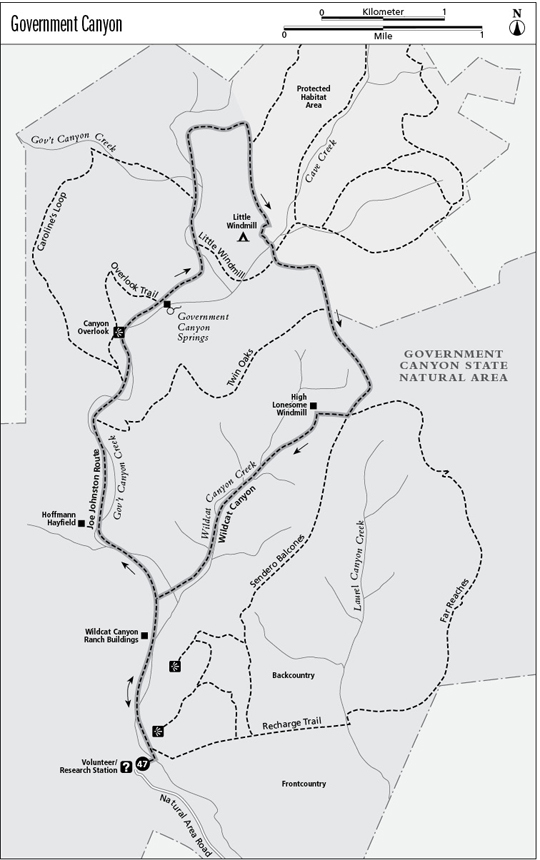
A day hike through the hilly backcountry of Government Canyon State Natural Area.
Distance: 9.2-mile lollipop
Approximate hiking time: 4 to 5 hours
Elevation: 1,020 to 1,390 feet
Trail surface: Dirt path and closed dirt road
Best season: Fall through spring
Water availability: None
Land status: State park
Nearest town: San Antonio
Fees and permits: Park entrance fee
Maps: USGS Helotes and San Geronimo; Government Canyon State Natural Area map
Trail contacts: Government Canyon State Natural Area, 12861 Galm Road, San Antonio 78254; (210) 688-9055
Finding the trailhead: From the junction of Texas Loop 1604 and FM 471 (Culebra Road) on the far west side of San Antonio, take FM 471 west for 3.5 miles to Galm Road. Turn right and follow Galm Road 1.6 miles to the park entrance, on the left where the road makes a 90-degree bend to the east.
The Hike
Government Canyon State Natural Area was created to provide recreation and to protect the San Antonio water supply. The park straddles the Balcones Fault that separates the Hill Country to the north from the South Texas plains to the south. Most of the Hill Country is part of the Edwards Plateau, a large area of land that was uplifted millions of years ago. Rain that falls on this part of the plateau seeps underground and recharges an enormous aquifer that supplies water to San Antonio, other towns, and agriculture. Development has sprawled across much of the recharge zone of the aquifer on the north and northwest side of San Antonio. This park and other areas of land have been purchased to help protect the recharge zone.
As of this writing the park offers day use only Friday through Monday. Because of budget problems, the park campground is not open, nor is backcountry camping allowed. That may change. The park comprises 8,622 acres and offers many miles of hiking and mountain biking trails. The park map is excellent, and the trails are well marked.
From the visitor center go to the right along the front of the building, past some exhibits, and onto an improved trail. The trail joins a large park road bridge over Government Canyon Creek. Cross the bridge to the signed trailhead on the left. Head north into the juniper thicket on the Joe Johnston Route. This hike will follow the Joe Johnston Route to its end and then continue on other trails.
The trail passes the Recharge Trail on the right in about 100 yards. Stay left. After about 0.8 mile, pass the Wildcat Canyon Trail on the right. It will be the return route for this hike. The trail climbs very gradually, following Government Canyon upstream through dense woods of Ashe juniper, live oak, cedar elm, and other trees. The creek is usually dry. The old Hoffmann Hay Field lies on the left about 0.5 mile past the Wildcat Canyon junction. The trail next passes the Twin Oaks Trail junction on the right. Stay left. Cliffs along the canyon become quite high.
Spanish moss cloaks live oaks in one part of Government Canyon State Natural Area.
Soon you reach Caroline’s Loop on the left. It offers a nice view of the canyon from a side trail, the Overlook Trail. For the main hike, stay right on the Johnston Route. Soon after Caroline’s Loop splits off, the trail passes through a pretty area of Spanish moss–draped live oaks and then reaches the historic Zizelmann House and the Overlook Trail junction. The house is fenced off to protect it from vandalism. Depending on rainfall, a spring sometimes flows down in the canyon below the house. Stay right on Johnston Route.
The next junction after the historic house is the Little Windmill Trail on the right. Taking it will cut about a mile off this hike’s loop. For the hike described here, stay left. Soon the trail passes the other end of Caroline’s Loop on the left. Stay right. The trail soon reaches its northernmost point, turns east, and becomes the Sendero Balcones Trail. It steadily climbs up out of the canyon bottom onto a ridge and then turns south. The trail passes the Black Hill Loop on the left near the ridgetop. It enters the protected habitat area, which is often closed in spring and summer to protect the endangered golden-cheeked warbler and other creatures. If the loop is open and time allows, taking it adds substantially to the hike distance. For this hike, stay right.
The trail soon descends back off the ridge to cross Cave Creek. Right after crossing the dry creek, the trail comes to a four-way junction. Go straight and stay on the Sendero Balcones Trail. The left fork is the other end of the Black Hill Loop; the right is the other end of the Little Windmill Trail. The trail climbs back up onto a ridge, the highest point of the hike. Like the other ridge, there are no good views; the vegetation is too thick. At another 4-way junction, the trail crosses the Twin Oaks Trail. Stay straight on the middle trail.
At the next junction, three possible return loops are possible. The middle fork, the Sendero Balcones Trail, continues south along the ridgeline but offers no good views. The left fork is the Far Reaches Trail. It offers a couple of good views back toward San Antonio and adds about 1.5 miles to the hike. For this hike, take the right fork, the Wildcat Canyon Trail. It goes west along the ridge a short distance to an old windmill, now a small radio repeater tower. The trail then drops down into Wildcat Canyon and follows it all the way to its confluence with Government Canyon. At the next junction, the Joe Johnston Route, go left and return the same way to the visitor center.
Miles and Directions
0.0Start at the trailhead at the visitor center. Follow the trail to right in front of the visitor center and across the park road bridge to the main trailhead.
0.15Main trailhead on park road. Follow Joe Johnston Route north.
0.2Recharge Trail junction. Go left on Johnston Route.
1.0Wildcat Canyon Trail junction. Go left.
1.6Hoffmann Hayfield.
2.1Twin Oaks Trail junction. Go left.
2.4Caroline’s Loop junction. Go right.
2.9Zizelmann House and Overlook Trail junction. Go right.
3.4Little Windmill Trail junction. Go left.
3.7Caroline’s Loop junction. Go right. Johnston Route soon becomes Sendero Balcones Trail.
4.5Black Hill Loop junction. Go right.
5.3Little Windmill/Black Hill Loop junction. Stay straight on Sendero Balcones Trail.
5.8Twin Oaks Trail junction. Stay straight on Sendero Balcones Trail.
6.5Wildcat Canyon/Far Reaches junction. Go right on Wildcat Canyon Trail.
8.2Johnston Route junction. Go left and return same way.
9.0Recharge Trail junction. Go right.
9.05Main trailhead on park road. Go right, across bridge and back to visitor center.
9.2Arrive back at the trailhead.