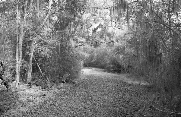
The trail winds through the dense woods of the Brazos River bottomlands.
58 Lake Jackson Wilderness Park
A day hike through a beautiful bottomland hardwood forest, a remnant of the once-extensive Austin’s Woods.
Distance: 5.0 miles out and back
Approximate hiking time: 2 to 3 hours
Elevation: 10 to 15 feet
Trail surface: Closed dirt road covered with grass
Best season: Fall through spring
Water availability: Buffalo Camp Bayou
Land status: City park
Nearest town: Lake Jackson
Fees and permits: No fees or permits required
Maps: USGS Lake Jackson and Buffalo Camp Reservoir
Trail contacts: City of Lake Jackson, Recreation Center, 91 Lake Road, Lake Jackson 77566; (979) 297-4533
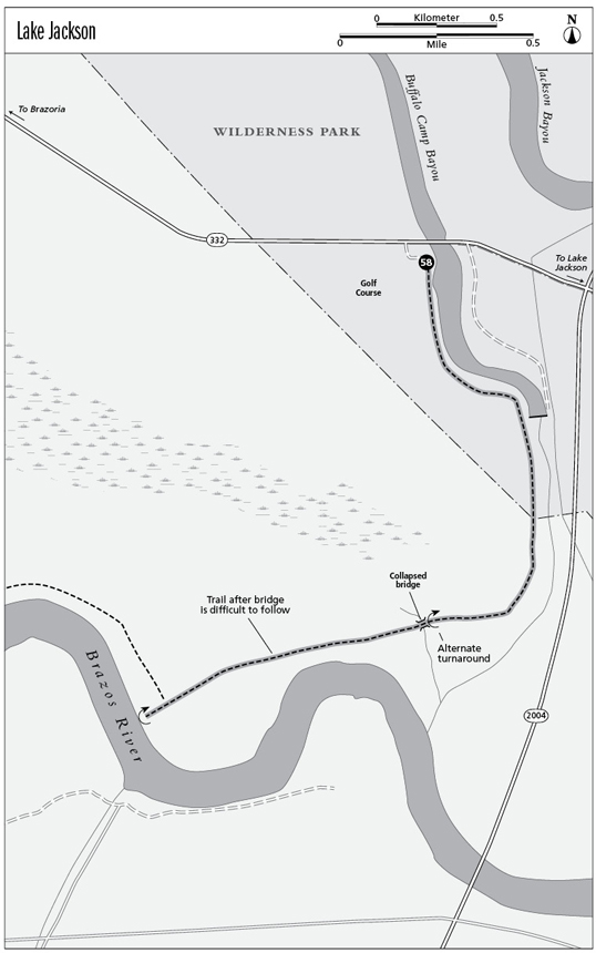
Finding the trailhead: From the junction of TX 332 and FM 2004 on the west side of Lake Jackson, go west on TX 332 for 0.5 mile to the Wilderness Park parking lot on the left, just across the highway bridge over Buffalo Camp Bayou.
The Hike
This hike passes through lush hardwood bottomland forest in the Brazos River and Buffalo Camp Bayou floodplains. The woods once covered 750,000 acres and lay inland from the coast along the lower sections of the Brazos, Colorado, and San Bernard Rivers. Development has cut the forest—known as Austin’s Woods or the Columbia Bottomlands—to a rapidly shrinking 175,000 acres. Tall oaks, hickories, and other trees dominate the forest canopy. Palmettos and other shrubs often form a thick understory. The remaining forestland is very important to migrating birds.
From the parking lot the trail follows an old road south along Buffalo Camp Bayou toward the Brazos River. Tall trees draped with Spanish moss arch over the trail. You’ll get a glimpse of the controversial city golf course that was recently carved out of the woods just to the west of the trail. In about 0.5 mile the trail passes a small dam that turns the part of the bayou that you have been hiking along into a small lake. Those churned-up areas of ground you see were damaged by feral hogs. FM 2004 is not usually visible from the trail, but the traffic noise is definitely audible.
The trail winds through the dense woods of the Brazos River bottomlands.
As the trail approaches the hidden confluence of the bayou and the Brazos River, it curves away from the bayou and into the woods to the west. The traffic noise from FM 2004 slowly diminishes as you move west. The trail soon comes to a collapsed wooden bridge at about 1.6 miles. Unless the route has been mowed and cleared recently, all but the most experienced hikers should stop here.
The trail continues on the other side of the bridge but has not been maintained since about 2002. You can either scramble across the ravine or, if it’s been cleared, follow an alternate route upstream a short distance to where there is a lower creek crossing. As of this writing, the trail on the other side of the bridge was becoming quite overgrown in the lush climate and littered with deadfalls. With care, experienced hikers can follow the trail a little less than 1.0 mile west to the river. Take a compass or GPS unit, and watch carefully for the route. The most confusing section is the first 200 yards or so just past the bridge. After that the old road gets a little easier to follow. It ends on a high mud bank of the Brazos River, one of the largest rivers in the state, with headwaters in eastern New Mexico. A large flow of usually muddy water rolls on by.
The trail, no longer an old road, continues upstream along the river for another 1.5 miles or so, but it has gotten almost impossible to follow. Maybe the city will clear the route again sometime; it’s a great trail.
The trail can get wet and muddy after a heavy rain. Mosquito repellent will sometimes be necessary. For this short a hike, it’s better to carry water than to try to purify bayou water.
Miles and Directions
0.0Start at the trailhead on TX 332.
1.6Old collapsed bridge. Unless the route has been cleared, only very experienced hikers should continue onward.
2.5Brazos River. Retrace your steps.
5.0Arrive back at the trailhead.