61 Laguna Atascosa National Wildlife Refuge
A day hike through the brushlands of Laguna Atascosa National Wildlife Refuge.
Distance: 4.5-mile loop
Approximate hiking time: 1.5 to 2 hours
Elevation: 10 to 20 feet
Trail surface: Dirt
Best season: Late October through March
Water availability: None
Land status: National wildlife refuge
Nearest town: Harlingen and Port Isabel
Fees and permits: Entrance fee
Maps: USGS Laguna Atascosa; Laguna Atascosa National Wildlife Refuge brochure
Trail contacts: Laguna Atascosa National Wildlife Refuge, P.O. Box 450, Rio Hondo 78583; (956) 748-3607
Finding the trailhead: From Brownsville take FM 1847 about 20 miles north to the intersection with FM 106. From Harlingen take FM 106 east about 19 miles to the same intersection. From the intersection go east on FM 106 about 4.4 miles to the parking area on the right, just before a small bridge.
The Hike
The 45,000-acre Laguna Atascosa National Wildlife Refuge was established in 1946 to preserve some of the Lower Rio Grande Valley’s rapidly shrinking wildlife habitat. Today, with rapid urbanization and extensive agriculture, less than 5 percent of the valley’s natural habitat remains. The small remnants harbor many birds and animals found nowhere else in the United States, such as the ocelot, jaguarundi, green jay, chachalaca, and Harris’ hawk. Because of habitat loss, some of these creatures are very rare and endangered. In addition to the unique species, the wildlife refuge’s location along migration routes gives it a very high bird count among more common species.
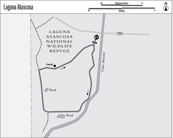
The refuge occupies low-lying coastal plain fronting the Laguna Madre—the long, shallow bay between Padre Island and the mainland. The habitat in the refuge ranges from salt marshes and estuaries to brushland vegetated with mesquite, ebony, prickly pear, huisache, yucca, retama, and granjeno. This hike, one of the least visited in the refuge, makes an easy loop through a brushland area of the refuge. It is not marked on all maps.
Like many other refuge trails, this one follows a service road closed to vehicles. Go through the gate to an immediate fork and go left onto the Cayo Fork. The right fork is the return leg of the loop. The left fork follows the shallow drainage of the Cayo Atascoso for a little more than 2.0 miles. The drainage may or may not have water in it. A pond at about 2.0 miles can often hold waterfowl. At 2.0-plus miles the trail cuts sharply right at a junction into the brush and away from the Cayo Atascoso. The left fork, a faint spur road, continues south along the cayo for a short distance.
The trail loops back north through the brush to the first fork and the trailhead. Along the way you will pass a small pond on the right and a corral on the left. Another faint road forks to the left after the small pond. Ignore it unless you wish to extend the hike.
This is an extremely hot and humid hike in summer and not recommended at that time of year.
The refuge has a number of other trails, making it one of the best areas in the valley for hiking. Most are short, but the loop around Laguna Atascosa itself is on the order of 15.0 miles.
Miles and Directions
0.0Start at the trailhead on FM 106. Pass through the gate to the trail fork. Go left on Cayo Fork.
2.2A little past a pond, turn sharply right at fork and head back north.
3.1After passing small pond, turn right; ignore the faint road going left.
4.5Arrive at end of loop and trailhead.