62 Santa Ana National Wildlife Refuge
A day hike through the native woodlands of the Rio Grande floodplain, with its unique wildlife.
Distance: 3.3-mile loop
Approximate hiking time: 1 to 1.5 hours
Elevation: 85 to 100 feet
Trail surface: Paved, gravel, and dirt
Best season: Late October through March
Water availability: Trailhead
Land status: National wildlife refuge
Nearest town: McAllen
Fees and permits: Entrance fee
Maps: USGS Las Milpas; Santa Ana National Wildlife Refuge map
Trail contacts: Santa Ana National Wildlife Refuge, Route 2, Box 202A, Alamo 78516; (956) 784-7500
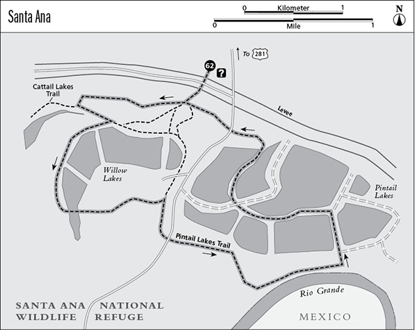
Finding the trailhead: From the intersection of US 83 and 281 in Pharr (just east of McAllen on US 83), go south on US 281 about 8.1 miles to the point where US 281 turns abruptly east. Go east on US 281 another 4.1 miles to the signed entrance to Santa Ana National Wildlife Refuge on the right. Park at the visitor center.
The Hike
Santa Ana National Wildlife Refuge preserves a small remnant of the woodlands that once lined the Rio Grande for many miles. The forests along both sides of the Rio Grande once harbored animals as exotic as the jaguar. Extensive agriculture and urbanization have all but eliminated the subtropical woodland from the Rio Grande Valley on both sides of the border. Today a few pockets of remaining natural habitat provide a last refuge for endangered species such as the ocelot and jaguarundi. Because of the proximity to Mexico and the subtropical climate, a number of birds are found at Santa Ana and other Rio Grande Valley sites that occur nowhere else in the United States. People flock to the refuge hoping to see such rarities as the chachalaca, kiskadee flycatcher, Harris’ hawk, and green jay.
The trail starts from the breezeway in the middle of the visitor center. Because the trail network is fairly complex, be sure to pick up a map at the visitor center before starting. The trail climbs over the Rio Grande levee and descends into dense, scrubby woodland, a startling contrast to the endless cultivated fields surrounding the refuge. At the multitrail junction across the levee, go right onto the Willow Lake Trail. Ignore the marked Cattail Lakes Trail that forks right after 0.3 mile. The trail then winds around shallow Willow Lake through dense forest. Cattails dot the surface of the small lake and waterfowl favor its protected waters. Spanish moss, some of the thickest in Texas, drapes the woods, creating a mysterious, primeval atmosphere.
On the far side of the lake, just past a photo blind, the trail intersects the Pintail Lakes Trail. Go right, onto that trail. After crossing the paved refuge road, the trail enters an area of more open and scrubby woods. It follows the high bank of the Rio Grande for a short distance before turning north to the Pintail Lakes. The lake is divided into several ponds. Several possible trails fork off at the lake, but the main trail is well marked. Finally the trail recrosses the paved refuge road and ends its loop at the multiple junction just across the levee from the visitor center.
The refuge is very hot and humid in summer and not very pleasant then. During the rest of the year, Santa Ana is a wonderful escape (and one of the few available) from the human-dominated landscape of the Lower Rio Grande Valley. Be sure to explore some of the other refuge trails during your visit.
Miles and Directions
0.0Start at the trailhead at visitor center breezeway. Follow trail over the levee.
0.1Multitrail junction across levee. Go right on the Willow Lakes Trail.
0.4Junction with Cattail Lakes Trail. Go left and stay on Willow Lakes Trail.
1.2Junction with Pintail Lakes Trail. Go right onto that trail and cross the paved refuge road. Stay on main, marked route through the various ponds that make up the Pintail Lakes.
3.0Trail crosses paved refuge road again.
3.2Loop ends at multiple junction at start of hike. Go right, over the levee to the visitor center.
3.3Arrive back at the trailhead.
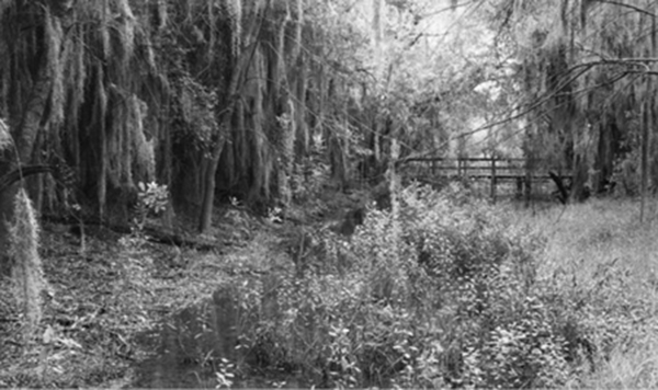
Spanish moss lends a mysterious atmosphere to parts of Santa Ana National Wildlife Refuge.