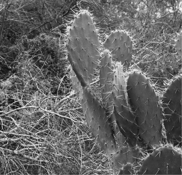
Prickly pears grow to an impressive size in South Texas.
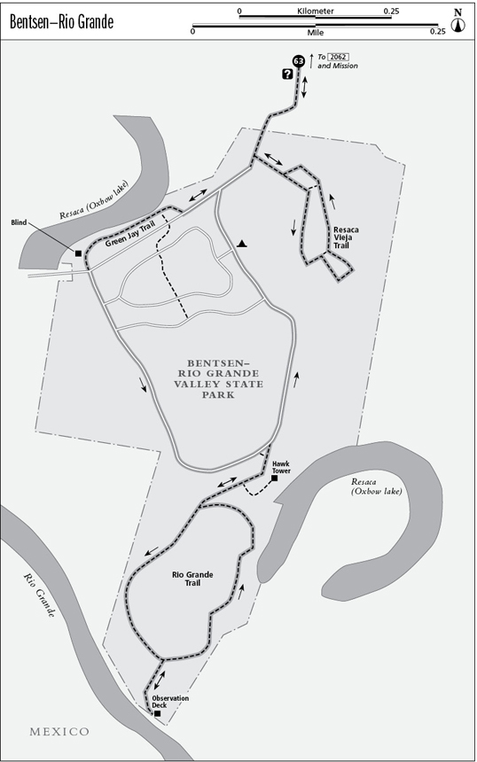
63 Bentsen–Rio Grande Valley State Park
A loop day hike through the bird-rich subtropical woodlands of Bentsen–Rio Grande Valley State Park.
Distance: 6.7 miles out and back
Approximate hiking time: 3 to 4 hours
Elevation: 100 to 115 feet
Trail surface: Paved road, dirt path
Best season: Late fall through early spring
Water availability: Trailhead at visitor center
Land status: State park
Nearest town: Mission
Fees and permits: Park entrance fee
Maps: USGS La Joya; World Birding Center/Bentsen–Rio Grande Valley State Park map
Trail contacts: World Birding Center/Bentsen–Rio Grande Valley State Park, 2800 S. Bentsen Palm Drive, Mission 78572; (956) 585-1107
Finding the trailhead: From US 83 on the west side of Mission, take the exit for Bentsen Palm Drive. Go west on the frontage road to Bentsen Palm Drive (the second stoplight). Turn left and follow Bentsen Palm Drive about 2.7 miles to the World Birding Center/Bentsen–Rio Grande Valley State Park parking area on the left and visitor center on the right.
The Hike
Bentsen–Rio Grande Valley State Park is one of the few public natural areas in Lower Rio Grande Valley. The vast majority of the natural habitat has been lost to the agriculture and urbanization of an exploding population. The native subtropical woodland and brushland of the park provides a small piece of habitat for the area’s remaining unique wildlife. Birds (and birders) flock to the park and the valley’s wildlife refuges, particularly during spring migration. A number of species are found nowhere else in the United States. Animals such as the ocelot and many types of plants are also found only in the valley.
The state park has become part of the World Birding Center and has made many changes in recent years. Private cars can no longer drive into the park, and only limited primitive tent camping is allowed. A tram that runs year-round follows the main park road loop and allows people to do a shorter walk than described here. Hikers, cyclists, and runners now use the park roads, with no vehicle traffic other than the occasional tram.
To do the entire hike, walk into the park from the visitor center on the main park road. You’ll soon pass the old park entrance station, now an interpretive center and restroom. In about 0.3 mile you’ll reach the trailhead on the left for the Resaca Vieja Trail. It’s an easy loop, with two shortcut loops. One side of the loop is accessible to wheelchairs. Just go right at every junction to follow the entire outer loop. The trail passes through one particularly dense patch of woods heavily draped with Spanish moss. The woodland along both trails is suffering, with many dead trees in evidence. With the construction of Falcon Lake upstream on the Rio Grande, the river is no longer allowed to flood. The water from the regular floods was essential to the survival of the woodlands along the Rio Grande. Not only has little woodland been left by human activities, the tiny remnants are suffering from a human-enforced drought. Efforts are being made to occasionally flood the forest here.
Prickly pears grow to an impressive size in South Texas.
Back on the main road, continue a short distance to a fork. Go right. Soon go right again onto the Green Jay Trail, which parallels the park road and starts by the boat ramp. It goes through an old section of campground along a narrow oxbow lake, La Parida Banco. A blind allows wildlife observation at the end of the Green Jay Trail. Go right where it rejoins the park road, and continue along the loop. The next left fork goes into the old campground loop, some more blinds, and two restrooms. Go right there and at the next fork (Roadrunner Crossing).
After about 0.6 mile you reach the Rio Grande Trail on the right. It passes through woods and brush on its way to the banks of the river. The trail forks soon after the start and begins a loop. Go right. The left fork makes a short spur to the Hawk Tower. (The tower offers the best views in the park and is an easy worthwhile side trip.) The trail soon forks again. Go right and follow the loop down to the river. A short one-way spur on the right leads to the river and back. Mexico is but a stone’s throw away. After the river, continue around the loop trail back to the park road. Go right on the road.
Go right at the next two forks (Roadrunner Crossing and the old campground loop). The third fork is the end of the main park loop road. Go right and return the same way back to the visitor center.
This hike can be shortened significantly by taking the tram. If you wish to take the tram for part of your hike, be sure to note the time when the tram stops running in the afternoon. The park is open until 10:00 p.m. (all night for tent campers), which allows nocturnal hiking with a light.
Miles and Directions
0.0Start at the trailhead at the main visitor center. Follow main road into park.
0.2Restroom and interpretive center.
0.5Resaca Vieja trailhead. Go left onto the Resaca Vieja Trail loop.
1.9End of Resaca Vieja Trail at trailhead on park road. Go left on park road.
2.1Road fork. Go right.
2.2Junction. Go right on Green Jay Trail.
2.25Kiskadee Trail junction. Go right, staying on Green Jay Trail.
2.5Junction with park road. Go right on road.
2.6Junction with old campground loop (Acacia Loop). Go right.
2.7Junction with Roadrunner Crossing. Go right.
3.3Trailhead for Rio Grande Trail. Go right onto trail.
3.4Junction with Hawk Tower spur. Go right.
3.5Start of trail loop. Go right.
4.1Spur trail to river. Go right on spur.
4.2Observation deck above river. Return to trail loop.
4.3Junction. Go right on trail loop.
4.9Junction at start of trail loop. Go right, passing Hawk Tower spur trail.
5.1End of Rio Grande Trail at park road. Go right.
5.5Junction with Roadrunner Crossing. Go right.
5.8Junction with old campground loop (Acacia Loop). Go right.
6.0Junction at start of main park road loop. Go right and follow main park road back to visitor center.
6.7Arrive back at the trailhead.