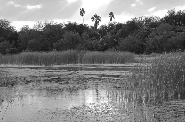
Cattails and other plants thrive in Ibis Pond.
64 Estero Llano Grande State Park
A hike past several ponds full of many species of birds and even a few alligators.
Distance: 3.2 miles out and back
Approximate hiking time: 1.5 to 2 hours
Elevation: 60 to 75 feet
Trail surface: Boardwalk, closed dirt road, dirt trail
Best season: Fall through spring
Water availability: Trailhead at visitor center
Land status: State park
Nearest town: Weslaco
Fees and permits: Park entrance fee
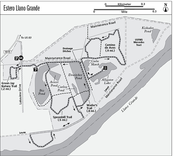
Maps: USGS Mercedes and Progreso; World Birding Center/Estero Llano Grande State Park map
Trail contacts: World Birding Center/Estero Llano Grande State Park, 3301 South International Boulevard, Weslaco 78596; (956) 565-3919
Finding the trailhead: From US 83 on the east side of Weslaco, take the exit for FM 1015/International Boulevard. Follow FM 1015 south for about 2.3 miles to the park entrance on the left, where FM 1015 takes a gentle bend to the southwest. Park in the lot on the right, just past the park entrance.
The Hike
Estero Llano Grande State Park is part of the World Birding Center, a collection of state and city sites that harbor exceptional numbers of birds and other forms of wildlife. The park is one of the newest in the state park system, the result of a concerted effort by private groups and local, state, and federal government agencies to protect the small remnants of native habitat that exist in the Lower Rio Grande Valley. At Estero Llano Grande, existing wetlands have been protected and new ones have been developed to foster wildlife. The park has quickly become known as an excellent place for birding.
The park has a network of short trails that I have pieced together into a loop. Because many of the trail segments are short, the distance estimates below have been rounded and are approximate. Be sure to bring along a pair of binoculars and enjoy the plentiful birdlife. Insect repellent may also be a useful addition to your pack, depending on recent rains. The hike is much more pleasant at cooler times of year.
From the parking area, walk the short paved path across a drainage ditch and Lakeview Drive to the visitor center. Pick up a trail map and enjoy the views of Ibis Pond from the shaded deck. The route follows a combination of the Spoonbill, Llano Grande, Wader’s, Camino de Aves, and Green Jay Trails. From the visitor center, walk east a short distance and turn right, taking the boardwalk over Ibis Pond. Cattails and other plants provide great cover for waterfowl and wading birds in the lake. Continue south and cross a segment of the Wader’s Trail. Turn right at the next junction with the Llano Grande Trail. Follow it south and up onto the levee, ignoring a left fork along the way. Go right on the levee. After a bit you’ll reach another junction, the start of a small loop. Go right and stay on the levee a short distance farther until the trail turns left and drops down off the levee. It offers views of Llano Grande Lake, an old flooded river channel cut by the Rio Grande and its tributaries. It soon climbs back up to the trail on the levee at the end of the small loop.
Cattails and other plants thrive in Ibis Pond.
Go right and backtrack along the levee. Walk down off the levee to the north to the first junction below the levee. Go right on the Wader’s Trail and loop around Dowitcher Pond. Pass the boardwalk that forks to the left and crosses the pond. At the north end of the pond, turn right and cross a bridge over a large drainage ditch. This bridge is new and may not show on some park maps. Once you cross the bridge, go right toward Alligator Pond. You can watch the birds in Grebe Pond as you approach Alligator Lake. At the lake, turn left and follow the spur trail along the bank of Alligator Lake. Keep an eye out for alligators. Unlike most of the park, this area is wooded and shady, plus it has a pavilion good for bird watching and relaxing.
Retrace your route back to the bridge over the ditch. Go right on the main part of the Camino de Aves Trail. The trail makes a double loop through dry brush dominated by mesquite. Follow the outer loop by going right at the first three junctions. At the fourth junction go left (the right fork is just a short spur that dead-ends). Go right at the next junction and return to the bridge. Cross the bridge again and go right. Follow the trail along the north side of Dowitcher Pond and then Ibis Pond, and return to the visitor center.
From the visitor center walk back toward the parking lot. On the way take the short loop through the thick woodland of the Green Jay Nature Trail. The thick, shady woods are a small remnant of the thorn forest that once covered large areas along the Rio Grande.
Miles and Directions
0.0Start at the parking lot trailhead. Turn left toward the visitor center.
0.05Main trailhead at visitor center.
0.1Go right onto boardwalk just past the visitor center. Walk between the ponds.
0.3Junction. Take middle fork.
0.5Junction. Go right.
0.55Junction. Go right and climb up levee.
0.6Top of levee. Go right along levee.
0.8Junction. Go right and stay on levee.
0.9Junction. Turn left and drop off levee.
1.1Climb back onto levee to junction. Go right and retrace route along levee.
1.3Junction. Go left down off levee.
1.35Junction. Go right around Dowitcher Pond.
1.5Junction. Go right, along Dowitcher Pond.
1.7Junction. Go right and cross bridge over ditch. Go right at junction on other side of bridge.
1.8Junction. Go left to end of spur trail at Alligator Lake overlook and then retrace route.
1.9Junction. Go right, back to junction with bridge.
2.0Junction at bridge. Go right on Camino de Aves Trail. Follow loop counterclockwise and go right at next three junctions.
2.5Junction. Go left.
2.6Junction. Go right at end of loop.
2.65Junction at bridge. Go right and cross bridge again. Go right again immediately after crossing bridge.
2.75Junction. Go right.
2.85Junction. Go right.
2.9Main trailhead at visitor center. Walk back toward Lakeview Drive and the parking lot trailhead.
2.95Lakeview Drive. Take the Green Jay Nature Trail loop.
3.15End of Green Jay loop on Lakeview Drive. Go left back to the parking lot trailhead.
3.2Arrive back at the parking lot trailhead.