65 Meridian State Park
Two day hikes through the hills and along the lake at Meridian State Park.
Distance: 4.1 miles total for both loops
Approximate hiking time: 2 hours
Elevation: 960 to 1,060 feet
Trail surface: Dirt, short paved section
Best season: Fall through spring
Water availability: Bosque trailhead
Land status: State park
Nearest town: Meridian
Fees and permits: Park entrance fee
Maps: USGS Meridian; Meridian State Park map
Trail contacts: Meridian State Park, 173 Park Road 7, Meridian 76665; (254) 435-2536
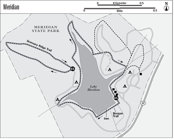
Finding the trailhead: From the junction of TX 6 and TX 22 in Meridian, go west on TX 22 for 2.6 miles to Meridian State Park on the right. For the Bosque Trail drive into the park about 0.3 mile to an unmarked junction above the small park lake. Park in the lot in front of the large stone CCC building on the lake below the junction. For the Shinnery Ridge Trail go left at the unmarked junction and drive around the lake about 1.3 miles on a winding, narrow paved road. Use care on the road. Park at the circle at the end of the road.
The Hike
Meridian State Park is a little-known state park about 50 miles northwest of Waco. The park lies in rolling hills wooded with Ashe juniper and oak. A small lake lies in the middle of the park, created by the Civilian Conservation Corps (CCC) when they dammed Bee Creek. The park has two main hiking trails, both of which are described here.
Bosque Trail
The first hike—the Bosque Trail—starts from the CCC building. Basically it circles the lake. Follow the lakeshore to the dam, and cross it to the other side. Go right, above the lake, on the other side. Watch out for occasional patches of poison ivy. After about 0.5 mile the trail joins the road for a short distance. Go right on the road, across a small bridge. After the bridge, leave the road. Walk through Campsite 24 and back onto the trail by the lake. Pass through two campsites on the lake in another 0.25 mile. The lakeshore forest is dense with oak, pecan, cedar elm, cottonwood, hackberry, and other trees.
A footbridge crosses the creek that feeds the upper end of the lake at a little more than 1.25 miles. At about 1.75 miles the trail climbs up onto a large limestone shelf overlooking the lake; this shelf is called Bee Ledge. Several trails lead from the ledge to the park road just above. At the road, there is a junction. Take the side road into the group campground for about 100 yards to a trail sign on the left. Take the trail a short distance to a junction. Go right at the signed junction on the Bosque Trail and down into a creek bottom. Go right at the trail junction in the creek bottom. Just down the creek, cross the road and walk through Campsite 27 and back onto the trail. In short order you will pass some screened shelters and be back at the start.
The Bosque Trail can be lengthened slightly by adding the two nature trail loops on the northeast side of the park.
Shinnery Ridge Trail
The slightly shorter Shinnery Ridge Trail starts at the other trailhead described above. A sign indicates the start of the loop trail at the parking area. A section of the loop is paved for wheelchair access. Most of the trail winds through dense juniper forest on relatively level ground. There are several benches and trail signs along the way.
After about 1.0 mile the trail runs into an old gravel road. Turn right and follow the old road back to the trailhead. To the left, the gravel road ends in 50 yards or so.
Although relatively shady, the trails are very hot in summer. Meridian must provide good armadillo habitat. I saw several while hiking these two trails.
Miles and Directions
Bosque Trail
0.0Start at the trailhead at CCC building.
0.5Trail temporarily joins park road and crosses bridge.
1.25Trail crosses footbridge at upper end of lake.
1.75Bee Ledge above lake. Climb up to park road and follow spur road that leads to group campsite.
1.85Leave road on left side on trail continuation.
2.1Junction. Go right.
2.2Junction in creek bottom. Go right and soon cross park road. Walk through Campsite 27 and back onto trail.
2.5Arrive back at the trailhead.
Shinnery Ridge Trail
0.0Park at the trailhead at the end of the road. Follow loop to left.
1.0Trail joins old gravel road. Turn right. Last section of trail is surfaced.
1.6Arrive back at the trailhead.
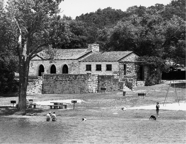
An attractive CCC building rests on the shore of Lake Meridian.