
Casa Grande Peak is one of the most distinctive peaks in the Chisos Mountains.
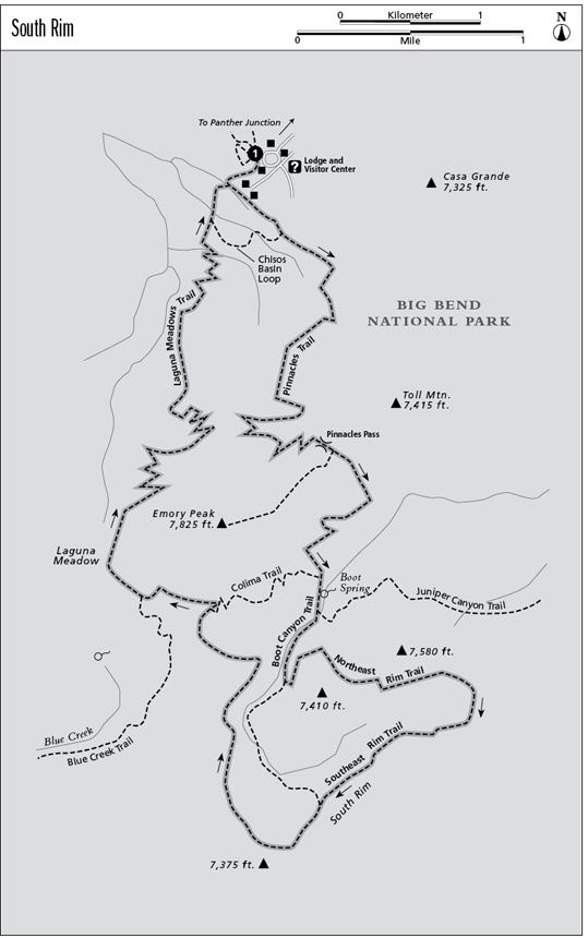
1 South Rim
A long day hike or overnight trip to the South Rim of the Chisos Mountains with spectacular views, mountain woodland, and rare birds.
Distance: 14.9-mile loop
Approximate hiking time: 8 to 10 hours
Elevation: 5,400 to 7,460 feet
Trail surface: Dirt path
Best season: Year-round
Water availability: Seasonal at Boot Spring, trailhead
Land status: National park
Nearest town: Terlingua/Study Butte
Fees and permits: Park entrance fee, permit required for overnight camping
Maps: USGS Basin and Emory Peak; Trails Illustrated Big Bend National Park
Trail contacts: Big Bend National Park, P.O. Box 129, Big Bend National Park 79834; (432) 477-2251
Finding the trailhead: From park headquarters at Panther Junction in Big Bend National Park, drive west on the highway toward the Basin and Santa Elena Canyon. Turn left (south) at about 3 miles onto the Basin Road. After almost 7 miles, stop at the large parking area at the lodge and visitor center at the end of the road. From this parking lot follow the sidewalk downhill (west) to the main trailhead sign.
The Hike
The South Rim is probably the classic Texas hike. Although the trip is fairly strenuous, almost any Texas hiker worth his or her salt will someday try to hike to the South Rim. Few other hikes in Texas can surpass the quality and sheer quantity of views along the trail. On clear days the views cover most of the Texas Big Bend country and far into Mexico.
To fully enjoy the trip, try to allow two or three days. For people in good shape, however, the hike can be done in one day. It can be shortened by about 2.3 miles by skipping the East Rim. Not surprisingly, this is a popular hike. Although there are many designated primitive campsites, it may be difficult to reserve one during Thanksgiving weekend or college spring break.
The described route is a loop. It is less steep to do the loop in reverse (counterclockwise) from what I describe. However, for backpackers planning to get water at Boot Spring, I recommend doing the loop as described. Be sure to check on the spring’s status before you start—it does dry up sometimes. If the spring is flowing, it will save having to carry part of your water up the bulk of the climb.
The trail starts from the bottom of the parking lot and immediately hits a three-way junction. As with all the trail junctions in the Chisos Mountains, this one is well marked. Go left, toward the Pinnacles Trail and the South Rim. The trail forks again in a short distance; go left toward Emory Peak on the Pinnacles Trail. You’ll pass several lodge cabins and a water tank. Ignore the Chisos Basin Loop trail forking right after about 0.5 mile.
The trail levels out for a breather at Juniper Flat and Boulder Meadow but generally keeps climbing at a moderate but unrelenting grade. After switchbacking steeply up the rocky wall of the Basin, the trail tops out with great views back down the way you came. If you’re hiking in October, you may see some beautiful fall maples along the trail a little below the top.
Casa Grande Peak is one of the most distinctive peaks in the Chisos Mountains.
After reaching the top, the trail starts down a tributary of Boot Canyon, passing the Emory Peak Trail on the right. After about 1.0 mile the Colima Trail forks to the right. Stay left toward the South Rim. The trail passes the corral and Park Service cabin. To find the spring, go down the slope into the canyon bottom behind the cabin a very short distance on an unmarked trail. Use as little water as possible; wildlife depends on it, too. Be sure to purify the water before drinking.
Boot Canyon is home to the Colima warbler, a Mexican bird that lives in the United State only in the Chisos Mountains. Similarly, that wilted-looking tree that grows in the canyon, the Mexican drooping juniper, occurs here only in the Chisos Mountains. The canyon is one of the lushest areas of the park, with Arizona cypress, bigtooth maple, and even a few Arizona pines and Douglas firs.
Ignore the Juniper Canyon Trail that forks off to the left a little past the spring. After another 0.5 mile, the trail forks again. Turn left and follow the trail to the East Rim. If you are tired or short on time, go right, straight to the South Rim. This will cut off more than 2.0 miles, but you will miss one of the most scenic parts of the hike. (Note: If peregrine falcons are roosting at the East Rim, you will have to go right at this junction because the Park Service closes access from about February to July.)
The trail to the East Rim makes a spectacular loop along the edge of the East and South Rims before rejoining the shorter right fork on the rim. Continue along the rim past the junction. The trail eventually turns back north away from the rim. After 1.5 miles or so, the trail passes the Colima Trail on the right and then, a short distance later, the Blue Creek Trail on the left.
After the Blue Creek junction, the trail passes through Laguna Meadow, a lush grassy valley with scattered pines and junipers. After the meadow, the trail begins the long descent back into the Basin and your car.
This hike will be hot in summer, but the trail is high and wooded enough to still be enjoyable. Get an early start for the climb out of the Basin. The trail is also good in winter, but be prepared for the occasional winter storm. The mountains will usually get a few snows, but they are usually light and short-lived.
Miles and Directions
0.0Start at the trailhead at the bottom of the lodge/visitor center parking lot. At the initial junction follow the left fork to the south, toward the South Rim. The trail drops slightly and leaves the developed area.
0.5Trail junction. Follow the Pinnacles Trail to the left.
3.4The trail levels out on the saddle between Toll Mountain and Emory Peak.
3.5Junction with Emory Peak Trail. Stay left.
4.5Junction with Colima Trail. Go straight on the Boot Canyon Trail.
4.8Junction with Juniper Canyon Trail. Go straight on the Boot Canyon Trail.
5.3Junction with Northeast Rim Trail. Go left on the Northeast Rim Trail.
8.6Junction with Boot Canyon Trail. Go left, continuing along South Rim.
10.3Junction with Colima Trail. Go left to Laguna Meadow.
11.1Junction with Blue Creek Trail. Go right toward Laguna Meadow and Basin.
14.4Junction with Basin Loop Trail. Stay left toward Basin.
14.9Arrive back at the trailhead.