70 Eisenhower State Park
A day hike on the rocky bluffs above Lake Texoma.
Distance: 8.0 miles out and back with small loop
Approximate hiking time: 3 hours
Elevation: 620 to 710 feet
Trail surface: Dirt
Best season: Fall through spring
Water availability: Trailhead, campground areas
Land status: State park
Nearest town: Denison
Fees and permits: Park entrance fee.
Maps: USGS Denison Dam; Eisenhower State Park map
Trail contacts: Eisenhower State Park, 50 Park Road 20, Denison 75020; (903) 465-1956
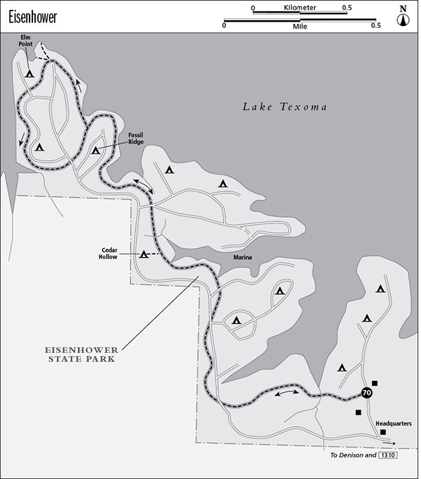
Finding the trailhead: From Denison go about 5 miles northwest on TX 75A to Denison Dam. Turn left on the south side of the dam onto FM 1310 and go 1.9 miles to Eisenhower State Park. Just past the park headquarters, go right at the road fork. The marked trailhead is on the left in a very short distance. A small parking area is on the right.
The Hike
Eisenhower State Park was named for President Dwight D. Eisenhower, who was born in nearby Denison. The park perches on rocky bluffs that rise out of the waters of Lake Texoma.
Coves cut deeply into the shoreline, creating a very irregular coast. Wave action from the large lake (one of the largest in Texas) is rapidly eroding the rocky bluffs. The hike winds its way around the coves and points through thick woods. The trail is not wild—it crosses park roads several times and passes several campgrounds. The mileage can be halved with an easy car shuttle within the park.
The trail heads straight into dense woods of oak, cedar elm, ash, and other trees. There are quite a few small ups and downs along the way. Poison ivy grows here and there. Limestone fossils abound in the bedrock.
The trail crosses the first park road in about 0.75 mile. The trail crosses roads again twice in a row at close to 1.5 miles. A short marked side trail to Cedar Hollow group campground goes left at about 2.0 miles. The trail crosses a road again at about 2.5 miles. As the trail circles the next point and the Fossil Ridge Campground, numerous side trails cut up to the campsites and down to the lake. The trail forks on the far side of the campground. Go right, toward the picnic area. The trail is hard to follow through the picnic area; just keep circling around the point until you find the trail again. The trail crosses another road at the Elm Point campground by zigzagging slightly to the right on the road. Continue to circle the campground, cross the road again, and wind up at the end of the loop. Follow the same route back to the trailhead.
The trail can be done in summer, but it is hot. The campgrounds are pleasant for spending the night before or after the hike.
Miles and Directions
0.0Start at the marked trailhead.
0.75First road crossing.
1.5Second and third road crossings.
2.0Spur trail junction for Cedar Hollow Campground. Go right.
2.5Fourth road crossing.
3.25Trail junction after Fossil Ridge Campground. Go right on loop.
4.0Fifth road crossing.
4.5Sixth road crossing.
4.75Trail junction at end of loop. Go right.
5.5Fourth road crossing again.
6.0Spur trail junction for Cedar Hollow Campground. Go left.
6.5Second and third road crossings again.
7.25First road crossing again.
8.0Arrive back at the trailhead.