2 Lost Mine Trail
A day hike to one of the most spectacular views in Texas.
Distance: 4.8 miles out and back
Approximate hiking time: 3 to 4 hours
Elevation: 5,760 to 6,850 feet
Trail surface: Dirt path and very short paved section
Best season: Year-round
Water availability: None
Land status: National park
Nearest town: Terlingua/Study Butte
Fees and permits: Park entrance fee
Maps: USGS Basin; Trails Illustrated Big Bend National Park
Trail contacts: Big Bend National Park,
P.O. Box 129, Big Bend National Park 79834; (432) 477-2251
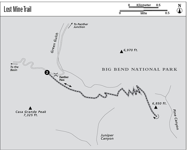
Finding the trailhead: From Big Bend National Park headquarters at Panther Junction, drive west toward Alpine and the Basin. At about 3 miles, turn left (south) onto the marked paved road to the Basin. After about 5.4 miles the road reaches a pass before dropping down into the Basin. Park in the large parking lot at the top of the pass.
The Hike
The Lost Mine Trail is one of the most popular hikes at Big Bend for good reason. The trail requires less climbing and is considerably shorter than the South Rim Trail but provides views that are almost as spectacular. Lost Mine Peak, rising above the promontory at the end of the trail, was named for a Spanish legend. Supposedly, at certain times of the year, the rising sun shines on the entrance of a rich mine developed by the Spaniards hundreds of years ago. Unfortunately, the Chisos Mountains are not geologically predisposed to that type of mineralization, making the legend probably only a fanciful story.
The trail climbs steeply southeast from the parking lot on a paved surface. Within 100 feet or so, the pavement ends and the grade moderates. An interesting self-guiding booklet is available at the trailhead.
The first 0.8 mile of the hike climbs gradually up to a saddle between Juniper Canyon and Green Gulch. The trail passes through piñon-juniper-oak forest, with the beautiful red-barked Texas madrone mixed in. The drooping juniper appears permanently wilted and occurs in the United States only in the Chisos Mountains. The excellent trail was built by the Civilian Conservation Corps (CCC) between 1940 and 1942.
The view from the saddle is spectacular and worthy of a trip in itself. However, it is only a warm-up for the view from the top. A primitive route climbs from the saddle to the southwest to the summit of Casa Grande Peak. The route is difficult and should only be attempted by expert hikers. Casa Grande Peak is usually closed from February to July to avoid disturbing nesting peregrine falcons.
After the saddle, the trail begins to climb at a steeper grade, with numerous switchbacks up a less-wooded southwest-facing slope. At roughly 2.0 miles the trail tops out on a ridge and follows it, ending on a spectacular rocky promontory at about 2.4 miles. Views stretch in all directions, from the surrounding peaks of the Chisos Mountains to the high peaks of the Sierra del Carmen far to the southeast in Mexico. In the canyon below the ridge to the north, a few Arizona pines manage to survive in the dry mountains. Since the Park Service doesn’t allow camping on the Lost Mine Trail, consider carrying a good flashlight so that you can watch the sunset over the mountains before descending.
The hike can be hot, but not unbearable, in summer. Rare snows may hit in winter, but overall the trail is good year-round. Be aware of lightning, especially during the afternoon thunderstorms of late summer. This hike is one of my favorites in Texas.
Miles and Directions
0.0Start at the Panther Pass trailhead.
0.8Juniper Canyon overlook.
2.0The trail tops out and follows a ridge.
2.4The trail ends at a rocky promontory. Enjoy the views before retracing your steps.
4.8Arrive back at the trailhead.