78 Huntsville State Park
A day hike through the thick woods surrounding Lake Raven in Huntsville State Park.
Distance: 7.0-mile loop
Approximate hiking time: 3 to 4 hours
Elevation: 240 to 355 feet
Trail surface: Dirt path
Best season: Fall through spring
Water availability: Trailhead, Lake Raven
Land status: State park
Nearest town: Huntsville
Fees and permits: Park entrance fee
Maps: USGS Moore Grove and Huntsville; Huntsville State Park trail map
Trail contacts: Huntsville State Park, P.O. Box 508, Huntsville 77342; (936) 295-5644
Finding the trailhead: Take I-45 about 5.5 miles south of Huntsville and leave the freeway at exit 109. Follow the signs into Huntsville State Park on Park Road 40. Park at the interpretive center about 1.6 miles into the park.
The Hike
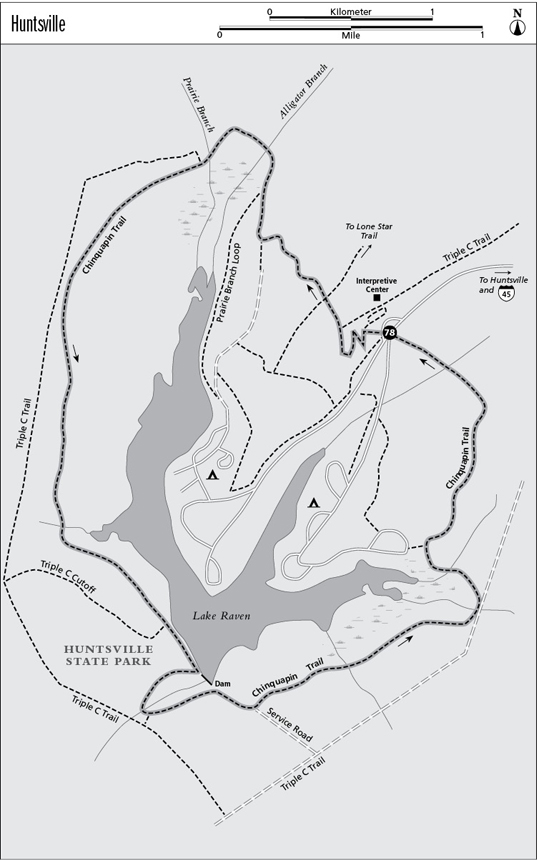
This Chinquapin Trail makes a big loop around Lake Raven, the centerpiece of Huntsville State Park. Part of the trail is shared with mountain bikers, and there are several alternate trailheads. A newer loop, the Triple C Trail, encircles this loop, following the park boundary much of the time. The Chinquapin Trail passes through lush woods of beech, loblolly pine, water oak, and many other trees. Be sure to get the updated trail map at headquarters to help find your way.
Start northwest, behind the interpretive center, on the nature trail. Ignore the short nature trail loop that immediately forks off to the right. The trail winds initially but eventually heads northwest. One branch of the Triple C Trail comes in from the right after 0.25 mile; stay left. After another 0.25 mile the trail hits a four-way junction. The left fork heads to the Dogwood Trail, the right to the Lone Star Hiking Trail (LSHT). Take the middle fork and continue northwest. After about 1.0 mile you will hit two junctions in a row; both are part of the Prairie Branch Loop. Go right both times. After the trail crosses the two small creeks of Alligator Branch and Prairie Branch, it turns southwest and hits another junction with the Triple C Trail. Go left and stay on the Chinquapin Trail. The trail passes through an area of upland forest and then works its way back to the lake, intersecting the Triple C Cutoff Trail. Go left and soon reach the dam a little more than halfway around the loop. The trail swings west to cross the creek below the dam. Just after crossing the creek, a trail forks right to connect with the Triple C Trail. Go left and go back up to the south side of the dam. From the dam the trail follows the spillway service road a short distance before turning off to the left. After about 1.0 mile the trail joins another dirt road, part of the Triple C Trail. Follow it left a short distance, across the creek, and fork left again off the road. In about 0.25 mile the main trail passes a short left spur that goes only to an alternate trailhead at the Coloneh Camping Area. After another 1.1 miles the hike ends at the starting trailhead by the nature center.
To avoid heat, humidity, and insects in summer, start early. Poison ivy is common. If you leave the trail, be careful not to get lost. If you take water from anywhere but trailhead taps, purify it. Be courteous; you will be sharing the trail with cyclists. The developed campground is attractive for overnight stays.
The 140.0-mile-long Lone Star Trail passes very near Huntsville State Park and was recently connected to the Chinquapin Trail near the nature center as noted above.
Miles and Directions
0.0Start at the trailhead at the nature center.
0.25Junction with Triple C Trail. Go left.
0.45Four-way junction. Go straight on middle fork.
1.0Junction with Prairie Branch Loop. Go right.
1.05Junction with Prairie Branch Loop. Go right again.
1.35Junction with Triple C Trail. Go left.
3.75Junction with Triple C Cutoff Trail. Go left.
4.15Junction with Chinquapin Cutoff Trail that connects to Triple C Trail. Go left, back to dam.
4.55Trail turns left off spillway service road.
5.5Trail hits Triple C Trail/dirt road. Go left onto trail/road.
5.6Trail turns left off Triple C Trail/dirt road.
5.85Junction with Coloneh Campground spur trail. Go right.
7.0Arrive back at the trailhead.