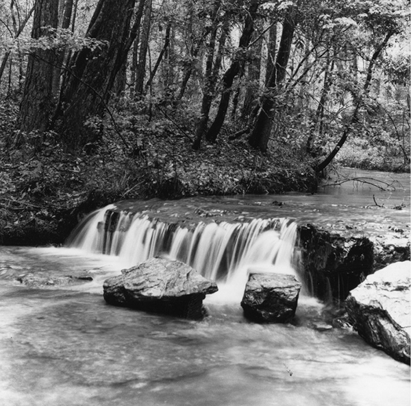
A small waterfall, rare in East Texas, lies deep in the Angelina National Forest.
79 Sawmill Trail
A day hike through the lush Angelina National Forest by creeks, a small waterfall, and the Neches River.
Distance: 11.0 miles out and back
Approximate hiking time: 4 to 5 hours
Elevation: 90 to 150 feet
Trail surface: Dirt path
Best season: Fall through spring
Water availability: Trailhead, Boykin Creek, Neches River
Land status: National forest
Nearest town: Zavalla
Fees and permits: No fees or permits required
Maps: USGS Boykin Spring; Angelina National Forest
Trail contacts: Angelina National Forest, 111 Walnut Ridge Road, Zavalla 75980; (936) 897-1068
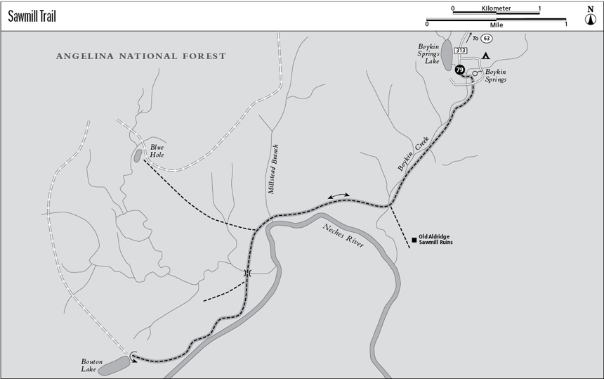
Finding the trailhead: From the junction of US 190 and TX 63 on the west side of Jasper, go about 2.5 miles northwest on TX 63. Turn left onto paved FR 313 (marked by a sign for Boykin Springs Recreation Area). Drive south about 2.9 miles to the recreation area. Park in the big day-use parking lot along the creek, just below the lake dam. A sign at the parking lot indicates the trail.
The Hike
The Angelina National Forest lies in the heart of the East Texas Piney Woods. Tall loblolly pines are mixed in with sweetgums, oaks, and many other hardwoods. The trail travels between two National Forest Service campgrounds, Boykin Springs and Bouton Lake. Like most East Texas trails, this trail crosses relatively level terrain with few elevation changes.
Hurricane Rita in 2005 did major damage to the Boykin Springs Recreation Area and the trail. As of this writing, the recreation area has reopened and the “middle half” of the trail is available for hiking. Posted signs direct hikers. Before you do this hike, be sure to call the forest to check on repairs, access, and any possible rerouting of the trail.
Cross the creek on the wooden footbridge at the parking lot and turn left through the campground. The trail is a bit tricky to follow through the campground. White dots painted on the trees help immensely. Very soon after turning left, the trail crosses the creek again, this time on cemented stepping-stones. From the stepping-stones go right, up the wooden stairs. Follow the white dots downstream, across the campground loop road, and into the forest.
A small waterfall, rare in East Texas, lies deep in the Angelina National Forest.
The trail follows the creek downstream for more than 1.5 miles. Depending on water flow, the creek makes a small waterfall partway down, a rarity in East Texas. The trail also crosses a dirt road at a little more than 1.0 mile. The trail forks at a little over 1.5 miles on an abandoned railroad grade. As indicated by the sign, you may take a 0.75-mile side trip to the left to the sawmill site at Old Aldridge. The old ruins of multiple large concrete buildings are interesting, with the forest slowly taking over the site. Teenagers have covered the walls with graffiti, but the short side trip is still very worthwhile. Otherwise turn right and continue to Bouton Lake along the old railroad grade. Several bridges and boardwalks make stream crossings easy. A marked, but somewhat overgrown, side trail to Blue Hole forks off to the right. Farther on, the small suspension bridge is fun to cross, but it may or may not be repaired when you visit.
The trail forks on the far side of the suspension bridge. Go left, following the omnipresent white dots, even though it appears less used. The right fork may also lead to Bouton Lake; I don’t know since I didn’t try it. Much of the last mile follows the banks of the Neches River. The trail ends at Bouton Lake.
Be careful if you leave the trail. It’s easy to get lost in the dense woods, especially on cloudy days. Rain is most common in spring, but take rain gear any time of year. Poison ivy can blanket areas of the forest floor, so watch for it. Mosquitoes, heat, and humidity can be miserable in summer, so plan to hike during other times of year. You may want to avoid the trail during deer season.
An easy car shuttle cuts the distance in half. Camping is allowed anywhere in the forest. The trail drains better than some East Texas trails. I did this hike in the midst of a very wet spring and was able to keep my feet dry. The trail is one of my favorites in East Texas, especially in late March when the azaleas and dogwoods are blooming.
This wonderful trail should be fully reopened sooner or later. Call ahead for its latest status.
Miles and Directions
0.0Start at the trailhead at the day-use lot.
1.1Trail crosses dirt road.
1.6Junction. Go right to Bouton Lake. Left fork goes to Old Aldridge Sawmill.
4.0Big Creek suspension bridge. Go left at fork just past bridge.
5.5Bouton Lake. Retrace your steps.
11.0Arrive back at the trailhead.