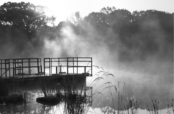
Morning mist rises over the park lake at dawn.
80 Fort Boggy State Park
A day hike through the woods and around a small lake in Fort Boggy State Park.
Distance: 3.5 miles total for both loops
Approximate hiking time: 2 hours
Elevation: 270 to 360 feet
Trail surface: Closed dirt road, dirt path, paved park road
Best season: Fall through spring
Water availability: Trailhead, Fort Boggy Lake
Land status: State park
Nearest town: Centerville
Fees and permits: Park entrance fee
Maps: USGS Leona; Fort Boggy State Park map
Trail contacts: Fort Boggy State Park, 4994 Highway 75 South, Centerville 75833; (903) 344-1116
Finding the trailhead: From Centerville (just off I-45 about 45 miles north of Huntsville), drive south on TX 75 for about 5 miles to the park entrance on the right. (From Leona drive north 2.3 miles on TX 75 to the entrance on the left.) Drive into the park to the small lake. Park in the lot above the lake.
The Hike
Fort Boggy State Park is a small park that lies just off I-45 on the edge of East Texas. It’s not quite far enough east to have many pines. The forest canopy is a mix of post oaks, hickories, elms, pecans, sweetgums, and other trees. Patches of open prairie are interspersed with the woods.
The park, named for a nearby fort dating to the 1840s, is quiet and undiscovered. It is open for day-use only, Wednesday through Sunday. Contact the park for events and other schedule information.
Morning mist rises over the park lake at dawn.
This hike combines two trails. Walk to the highest point in the parking lot (farthest from the lake), where a small dirt road leads west into the woods. The first part of this trail passes primitive campsites with tables, fire rings, and lantern posts. When the park budget improves, these sites should be available for overnight camping. Follow the closed dirt road uphill past the first campsite for about 200 yards to a cleared pipeline right-of-way. Go left and follow the right-of-way on the dirt road for maybe another 200 yards. Follow the road to the right where it turns off the right-of-way and back into the woods. At about 1.0 mile the dirt road forks between two of the campsites. Go left. The right fork just shortcuts back up to the right-of-way.
Soon the road enters beautiful bottomland with large, old trees. A few old farm structures are crumbling away in the woods. The road leaves the woods, enters a meadow, and crosses the same right-of-way again. It then enters a scenic “tunnel” of young sweetgums that arch over the trail. The trail then hits the right-of-way of a second pipeline. An optional short walk to the right on the right-of-way takes you to the park entrance building and shortens the loop slightly. For this hike, continue on the dirt road across the right-of-way and back into the woods. The trail then curves right and hits the paved park road near the entrance. Go right on the park road and follow it back to the lake parking lot.
For the second part of the hike, walk to the road that leads down to the boat ramp on the northeast side of the parking lot. The trail starts by the powerline and then drops down to the lake’s dam. Look for the trail signs. Cross the earthen dam and follow the trail to the right along the lakeshore on the other side. The trail loops around the lake and ends back at the picnic area below the parking lot.

Miles and Directions
Primitive Campsite Trail
0.0Start at the trailhead at lake parking lot. Follow dirt road west from area of the parking lot farthest from the lake.
0.1Pipeline right-of-way. Go left on dirt road that follows pipeline.
0.2Leave pipeline right-of-way by turning right and following dirt road into woods.
1.0Junction. Take left fork of dirt road.
1.5Pipeline right-of-way. Stay on road and cross the pipeline.
1.8Second pipeline right-of-way. Stay on road and cross the pipeline.
2.0End of trail at park entrance road. Return to trailhead by turning right and walking back up road to parking lot.
2.2Arrive back at the trailhead.
Lake Trail
0.0Start at the trailhead at lake parking lot and turn right onto the trail. Trail starts under powerline at top of boat ramp spur road. It crosses the dam and loops around the lake.
1.25Picnic area below lake parking lot.
1.3Arrive back at trailhead.