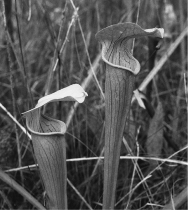
Carnivorous pitcher plants eat insects to supplement the poor soils in which they grow.
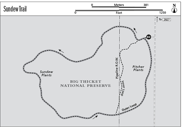
83 Sundew Trail
A day hike through pine-savanna wetlands with carnivorous plants.
Distance: 1.6-mile loop
Approximate hiking time: 45 minutes to 1 hour
Elevation: 115 to 130 feet
Trail surface: Dirt path, paved path, and boardwalk
Best season: Fall through spring
Water availability: None
Land status: National preserve
Nearest town: Woodville
Fees and permits: No fees or permits required
Maps: USGS Warren; Sundew Trail booklet (National Park Service); Big Thicket National Preserve map and brochure
Trail contacts: Big Thicket National Preserve, 6044 FM 420, Kountze 77625; (409) 951-6725
Finding the trailhead: From Woodville drive about 17 miles south on US 69-287 to FM 2827. Turn right and drive about 0.6 mile to a good dirt road on the left marked with a big thicket - sundew trail sign. Drive about 0.5 mile down the dirt road to the marked parking area on the right.
The Hike
The Sundew Trail lies in the Hickory Creek Savannah Unit of the Big Thicket National Preserve. The unit protects one of several biological associations found in the thicket. The short loop trail passes through acid bogs and a young stand of longleaf pines. Most of the plant community is fairly open, without the heavy forest common to much of the thicket. The extra sunlight makes the area better than average for producing wildflowers.
The hike follows a short, easy loop, with boardwalks crossing the boggy areas. A shorter 0.8-mile loop is mostly boardwalk and pavement and is wheelchair accessible. Even the outer loop could probably be done with a wheelchair. The young longleaf pines found on part of the hike used to be common over much of southeastern Texas. Unfortunately, they produce a very durable pine lumber and have been heavily logged. Since longleaf pines are slow growing, slash, loblolly, and shortleaf pines are usually planted to replace them. The longleaf pines once grew to 125 feet tall, but very few old ones are left.
Carnivorous pitcher plants eat insects to supplement the poor soils in which they grow.
The Park Service shows a length of 1.6 miles for the outer loop, although it seems closer to 1.0 mile in reality. The park shows the inner loop as 0.8 mile, but it seems considerably shorter to me. This hike describes the outer loop, but the loops are so short that you can easily do both.
Be sure to look carefully for the two carnivorous plants along the trail—the pitcher plant and the sundew. Because of poor soils in their chosen habitat, they supplement their diet by trapping and consuming insects. Pick up the brochure and map at the trailhead; it will help you find the unique plants.
Since the trail is short, it can be done any time of year. But, as with other Big Thicket trails, the most comfortable hiking is in the fall through spring.
Miles and Directions
0.0Start at the trailhead in the marked parking area. Take the right fork from the parking lot and then turn right again to follow the outer loop.
1.3Junction. Go right on the outer loop.
1.6Arrive back at the trailhead.