
Oich Suspension Bridge
The Duke of Bedford built the bridge at Oakley in 1815. It has five segmental stone arches supporting a roadway only 10ft wide and, separated from the rest of the bridge by a small island, there is an earlier single-arch bridge over the mill stream. This was originally segmental but was widened with semi-elliptical arch extensions when the rest of the bridge was built. BBeds, BEVA, CEHE
The first bridge over the River Ogmore just downstream from where the Llynfi joins was built in 1829. It has three semicircular arches and elaborate stepped cutwaters on the two river piers. It was bypassed in 1997 by a prestressed concrete viaduct with five spans – four of 81m and one of 54m. The two, parallel, steel box girder spine beams are connected by precast I-beams prestressed transversely into the boxes to form an integral ladder-like structure. This arrangement gives the bridge great torsional stability, allowing the columns beneath the two spine beams to be staggered longitudinally so that the short 54m spans are at opposite ends under each carriageway. ABWWE, NCE
James Dredge’s Oich Suspension Bridge was built in 1850 to his patented hybrid design of part suspension bridge, made of parallel flat eyebar chains, and part rod-stayed cantilever. At the end of each eyebar link in the chains one chain is discontinued and its share of the tensile force is taken by a diagonal rod that continues down to support the bridge deck. The Grade A bridge, which spans 155ft between masonry towers consisting of two legs joined at the top by an arch capped by a low pediment, is now under the care of Historic Scotland. The Great Glen Way crosses the Caledonian Canal on the bridge. BPJ, CEHSH, HB
Oich Suspension Bridge
The old road along the south bank of the Tyne crossed a narrow ravine just outside the entrance to Prudhoe Castle on a small medieval bridge that still stands. The original four-ribbed semicircular arch spans about 9ft between tall abutment faces and supported a roadway about 10ft wide. This road was later widened by about 4ft when the abutments were extended and a pointed rib was built to support a new upstream face. ABNE
There was a bridge here in 1343, but the present crossing probably dates from Elizabethan times. The main structure has five nearly semicircular stone arches, each with three wide ribs beneath, the largest arch spanning just over 15ft. The four river piers have large upstream and smaller downstream pointed cutwaters, all of which extend up to the low parapet level to form pedestrian refuges. In Tess of the d’Urbevilles Thomas Hardy describes how Tess and Angel Clare cross the bridge to reach Wellbridge Manor for their ill-fated honeymoon. ABSE, BB, BBPS, BG, BiB, BME, DBHG, DDB

Old Bridge, Wool
The first bridge at Chester was built by the Romans and there was probably a bridge there again by around 900. A later timber structure, mentioned in the Domesday Book, was built towards the end of the eleventh century and floods destroyed a further replacement in 1280. In about 1300 the bridge was rebuilt by Master Richard, the ‘Ingeniator’, one of the first recorded uses in English of the word ‘engineer’. All these later structures may have used all or some of the Roman stone piers. The present Grade I stone bridge, slightly upstream from the earlier site, is thought to date from about 1387. Because the bridge was the only route from Wales into the city, its defences included a heavily fortified gate tower and drawbridge on its southernmost pier, although these were demolished in 1781. In typical medieval fashion, as a result of parts of the structure being rebuilt following flood damage and other dilapidations, the bridge has a variety of arches: four pointed, one semicircular and two later segmental spans at the city end. In 1826 the bridge was widened with a corbelled footway but was soon bypassed when the new Grosvenor Bridge (qv) was opened in 1833. In 1645 Parliamentary forces besieging Chester built a bridge of boats about half a mile upstream from the old bridge. ABWWE, BB, BBPS, BEVA, BiB, BLP, CEHWM, DB, NTBB
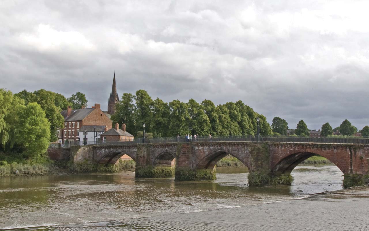
Old Dee Bridge
All that remains of this now disused bridge is the high segmental arch ring that spans about 20ft over Forss Water. The voussoirs are not specially shaped stones as on most arch bridges but include many thin ‘Caithness flags’, flagstones that are typical of this part of Scotland. HB
Built around 1510 to replace an earlier timber bridge, this bridge has three segmental stone arches of 23ft span. It is only 9ft wide, but three of the four cutwaters have pedestrian refuges and the bridge has been bypassed for many years. ABNE, BLY, CEHN, PBE, SYBBR
A very early ‘Mannysbrigge’ was mentioned in a charter of 932 and a later one was reported in 1403 as needing repair. The present bridge, however, dates only from 1816 and was built when the River Itchen was being actively used for barge traffic between Southampton and Winchester. It is about 18ft wide, has a single segmental stone arch spanning about 30ft and solid parapet walls above a strong string course. The face of all the stonework has been lightly scored in diagonal lines to produce the so-called ‘lambswool’ finish. The Itchen Way passes the bridge on the river’s south bank. ABSE, BHHI

Old Mansbridge
This bridge, built to carry the road from Fort William over the River Oich into Fort Augustus, was originally a stone structure of four spans built in 1746. All but one of these, a segmental stone arch, was swept away in 1849. In their place there are now four spans each of five timber beams supported by intermediate timber trestles, from which there are also additional raked props to approximately the third points of the spans. The bridge was bypassed in 1932 by the new Augustus Bridge which now also carries the Great Glen Way. HB
This bridge, which may date from the late sixteenth century, originally had three arches but, following flood damage in 1829, now consists only of two arch rings, made from noticeably thin voussoirs. The steepness of the approach onto the arches indicates that earlier spandrel walls and filling have probably been removed. HB
Despite being called Old Roman Bridge, this is not, of course, an old Roman bridge, although it is very possible that the Romans did build a bridge hereabouts. Known also as Prescott Bridge, the present structure has two segmental stone arches, one of which is ribbed, and probably dates from the fifteenth century. The Jack Mytton Way now crosses the bridge. HBS
The first bridge over the River Adur at Shoreham was completed in 1782 as part of a new highway along the south coast and replaced an ancient ferry. Built by Joseph Hodskinson on behalf of private subscribers, it was a simple twenty-three-span timber trestle structure carrying a 12ft-wide road. The bridge included two Coade stone animals that were moved to Norfolk Bridge (qv) when that was built in 1832 to relieve the old structure. In 1916 the bridge was rebuilt in a similar style but with twenty-seven skew spans, typically about 14ft long, and a 14ft-wide road with two wider passing places. The A27 now bypasses the town to the north, crossing the Adur on a concrete bridge built in 1970, leaving the Old Bridge to continue as a footbridge. It was rebuilt in the 1980s as an identical copy and restored again in 2008. The Downs Link starts from the east end of the bridge. ABSE, BB, CEHS, DB

Old Shoreham Bridge
The bridge over the River Spey at Fochabers was first built in 1804. It was a handsome structure with four stone segmental arches – a central pair of 95ft span flanked on each side by an arch of 73ft span – connected by a long causeway at the south end to the dry land. The middle of the structure was marked by a wide pilaster on the face of the central pier, with oculi in the centre of the spandrels above the two side piers. The northernmost pier collapsed during floods in 1829, bringing its two arches down with it. These were replaced in 1832 by a 185ft-long three-ribbed timber arch, Britain’s longest timber arch at the time. In 1854 this, in turn, was replaced by a three-rib cast iron arch, later strengthened in steel. The Grade A bridge no longer carries road traffic, having been bypassed by a modern steel box girder structure. The Speyside Way passes the south-east end of the bridge. ABTB, BiM, CEHSH, HB

Old Spey Bridge
A bridge here over the Avon was in decay in 1278 and the present bridge, built by monks from the nearby Stoneleigh Abbey, possibly dates from a further rebuild in 1352. It has three main river and six flood spans, all of which are nearly semicircular pointed arches. The intermediate piers, protected by upstream cutwaters that continue up to parapet level, are about as wide as the arch spans. The Coventry and Centenary Ways both cross the bridge. ABWWE, DB, NBBB, NTBB
The first bridge here was a chain suspension bridge built in 1826 which collapsed in 1870 due to overcrowding. More than 100 people fell into the River Wansbeck but fortunately all survived. The bridge was repaired but collapsed again the following year as a result of ‘idle fellows’ jumping and dancing on it despite warning notices, with more than 200 people thrown into the river but again with no fatalities. The second bridge, a much stronger iron girder structure, was completed in 1875 but was moved to a new downstream site in 1931. The third Oldgate Bridge, another lattice girder, was replaced by the present bridge in 1970 following floods in 1963. This is a reinforced concrete structure with a central shallow segmental arch flanked by a half-arch at each end.
A medieval bridge over the Great Ouse at Olney was recorded as needing repair in 1351. A later structure, built in 1619, was replaced in about 1820 by the present bridge that has five main segmental stone arches and further smaller flood relief arches. This bridge was widened in the 1970s. The Ouse Valley Way uses the bridge to cross the river. ABMEE, BME, CEHE
As part of the infrastructure for the 2012 London Olympics, 30 bridges and more than 20km of new road were built in the 2.5sq km Olympic Park. The showpiece Central Park Bridge is a 26m-span footbridge over the River Lea at the focal point of the Park. During the games it was 55m wide but afterwards temporary sections were removed to leave two narrower permanent bridges. Another major bridge forms the link between the Olympic Park and the Stratford City retail and leisure development. Supported by an arch spanning 87m, its 18m-wide deck carries four lanes of traffic as well as two footpaths. The Olympic Park is now a public park and many other road and pedestrian bridges built for the Games still remain. Another nearby bridge built under the stimulus of the Olympics was the Stratford Town Centre Link Bridge (qv). NCE
This viaduct, completed in 2017, supports 300m of new track linking Manchester’s main railway stations. It consists of nine separate steel structures but the main one, the River Irwell Crossing, is the UK’s first network arch bridge and the first asymmetric network arch bridge in the world. This is 90m-long and crosses the river on a skew and is also distinctive for being built in weathering steel. The bridge was designed by the AECOM Mott MacDonald JV.
Orwell Bridge was completed in 1982. It carries the A14 trunk road across the River Orwell and bypasses the town of Ipswich. The 1,296m-long 18-span bridge consists of two parallel, continuous, post-tensioned concrete box girders, cast in situ, which together provide a 24m-wide deck. The 190m main navigation span was built as a balanced cantilever structure and is still the longest prestressed concrete span of its type in Britain. This is flanked each side by a side span 106m long. The depth of the box girder over these three spans increases from the constant 4m depth of the approach spans to a maximum of 12m to give the appearance of an arch and two half-arches. The bridge, which was designed by Halcrow and built by Volker Stevin, has won awards for engineering excellence. There is a good view of it from the Stour and Orwell Walk which passes under the western end. BFB, BG
The Augustine monks had probably built and maintained bridges across the Thames on this site from shortly after the priory at Osney was founded in 1129 until Henry VIII appropriated their property more than 400 years later. In 1769 their surviving three-span stone structure was replaced by a new 20ft-wide bridge with seven small semicircular stone arches. Part of this collapsed in 1885, killing a young girl, and in 1888 the existing bridge was completed. This has a six-ribbed, 60ft-span, segmental, wrought iron central arch, its very low rise limiting access further upstream to small boats only, which is flanked by two small stone side arches. The bridge now carries the A420 Oxford to Botley road and The Thames Path crosses from one river bank to the other at this bridge. BoT, MBO, TBDS, TC

Osney Bridge
Built in 1850 to carry the railway from Oxford to Banbury over the Thames, the first bridge originally had three wrought iron, plate girder skew spans, a central span of 60ft and smaller side spans. This bridge was rebuilt in 1898 with a single 87ft-long steel plate girder river span and, in 1981, these plate girders were replaced by a steel box girder structure. In 1887 a second bridge was built just downstream of the first bridge of 1850 to carry goods traffic and the earlier structure was then demolished. The Thames Path passes beneath the bridge on the river’s south bank. BoT, TBDS, TC
An unusual structure here, which was built around 1780 but has long been out of use, served both as a land bridge connecting the parkland to an island within the Garden Lake and also as a covered boathouse. The brick bridge, which has a semicircular arch spanning about 20ft, is 40ft wide. In the centre of the grassed approach is a stone stairway which leads down through the arch barrel to end at the water’s edge. This thus enabled passengers to step directly into the boat for trips on the water. The park and house is in the care of the National Trust.
Originally within the northern part of the park, but now separated by the M4 motorway, is the Roman Bridge that was built by Robert Adam in 1780. This has a flat segmental stone arch spanning between abutments, each of which is decorated with a pair of Doric half columns that support a panelled section of parapet wall, but is now very dilapidated.
The bridge over the M65 taking a minor road from Blackburn to Oswaldtwistle was built in 1997. It is a reinforced concrete arch spanning 57m across a motorway cutting on a 20° skew. The arch, which is 6m wide at the crown and tapers to be narrower at the springings, supports the road deck on four spandrel cross-walls. NCE

Oswaldtwistle Bridge
Following on from earlier timber bridges, this stone bridge over the River Wharfe was first built in 1228 with seven low segmental ribbed arches. As a result of severe flood damage in 1673 two of these had to be rebuilt and are no longer ribbed. In 1776 the bridge was widened on the upstream side from about 8ft to about 20ft and a cantilevered footway has been more recently added to the downstream side that carries the start of the Six Dales Trail. ABNE, BB, BiB, BLY, BME, SYBBR

Otley Bridge
In 1907 an earlier single-track swing bridge on this site was replaced by a centrally pivoted double-track swing bridge built by the Great Eastern Railway. The movable span, consisting of 120ft-long plate girders with their ends supported by diagonal rod stays from a central portal frame over the railway, is flanked by three smaller fixed side spans. The bridge can be seen from the Angles Way which passes over the adjacent road bridge. BHRB, BRBV, CEHE
Ousedale Bridge, designed by Telford and built in about 1818, is typical of the ruggedness of many bridges built at this time to open up the way to the far north of Scotland. It has a semicircular coursed rubble stilted arch in the middle of what is effectively a high stone wall, since the abutments are not differentiated visually from the wing walls that run up the steep valley sides to support the approach road. These wing walls are stabilised laterally by heavy triangular stone buttresses. HB
The Selby bypass swing bridge over the River Ouse, opened in 2004, is a cable stay structure with a 55m main span and a 40m back span. A hollow-section concrete pier supports a single mast that pivots 90° on a slew ring. Two pairs of cables pass over this mast and connect to the deck at about the third points of each span. The Trans Pennine Trail passes under the north end of the bridge. NCE
The old fifteenth-century St Ives Bridge (qv) was finally bypassed with the opening in 1980 of the new reinforced concrete Ouse Bridge to the south of the town. The twenty-five land spans consist of a continuous flat slab deck, and the three river spans, of 18, 33 and 18m, have curved soffits. NCE

Ouse Bridge, St Ives
There was almost certainly a Roman bridge at York, although no traces have been found. A later timber bridge collapsed in 1154 when crowded with people, but no lives were lost, a miracle that legend attributed to Archbishop Fitzherbert, who was later canonised. The medieval stone Old Ouse Bridge was probably completed around 1180 and had four main ribbed and pointed river arches and two side flood arches. As well as a council chamber on the bridge (with, in the spandrel area beneath, two civic prisons – the mayor’s and the sheriff’s ‘kidcotes’), a chapel was soon built and this survived until its dissolution in 1547, after which it continued as a cloth hall until it was demolished in 1809. Shops and houses, too, were built on the bridge from the early fourteenth century and were not finally removed until the eighteenth century. In 1565 the two central arches of the bridge collapsed, destroying twelve houses, and these were replaced in 1566 with a single high segmental arch spanning 81ft, later described as ‘the fairest arch in England’. However, the narrowness of the bridge and the steepness of the road over the main arch became less and less acceptable and in 1820 the present bridge was completed on the same site, having been built in two longitudinal sections in order to maintain access during construction and demolition. It has three semi-elliptical stone arches, a central one spanning 75ft and side arches of 64ft, and is 43ft wide. ABNE, BiB, BLY, BME, BoB, CEHN, DoB, FFB, YBBR, Wilson

Ouse Bridge, York
John Urpeth Rastrick was the engineer for this magnificent viaduct, built to carry the London & Brighton Railway 96ft over the River Ouse and opened in 1841. There are thirty-seven semicircular brick arches spanning 30ft between slightly tapering paired piers that are linked top and bottom by semicircular arches and inverts. The architect David Mocatta designed the elegant stone balustrade, with corbelled refuges over each pier, and the four small classical-style pavilions that stand on the abutments at each end of the viaduct. Unfortunately, recent restoration work has used non-matching bricks. BEVA, BFB, BHRB, BRB, BRBV, CEHS, RHB

Ouse Viaduct
This viaduct was originally built in 1839 as a series of glued and laminated timber arches to a design by John and Benjamin Green, and was similar to their larger Willington Viaduct (qv). Each arch contained fourteen layers of Baltic softwood timber. The bridge was rebuilt in 1869 in wrought iron but with a similar overall appearance, and was widened to take four tracks in 1885. There are five main spans approximately 115ft long, each with six arched ribs, and two short masonry arch spans at each end. BHRB, BRBV, CBTT, CEHN, IANEE

Ouseburn Viaduct
The first crossing here, built in 1846, was of timber. The present viaduct of five cast iron arches, each consisting of six ribs spanning between stone abutments with intermediary brick piers, was built in 1881 to carry the Lancashire & Yorkshire Railway over the River Irwell. The disused structure has now been restored to carry the Outwood Trail. BHRB, RHB
Telford built this 25ft-wide 150ft-span masonry arch over the main West Channel of the River Severn in 1828 and it is now in the care of English Heritage. A feature of the bridge is the unusual cornes-de-vache shape of the arch when seen in elevation, a design concept usually first attributed to Perronet at his Seine bridge at Neuilly. This is formed by the tapering soffit between the central semi-elliptical arched barrel section of the bridge and the segmental arch of its face, both curves having a common tangent point at the apex. A new bypass bridge was built in 1975 for the A40 and the original bridge now carries the Three Choirs Way. ABTB, BE, BEVA, BoB, CEHWW, CoB, DB, MBVA, TT
Over Bridge
The bridge here over the River Tyne was completed in 1883 to replace a ferry, which itself replaced an earlier ford. Each of the seven intermediate supports consists of two tubular wrought iron A-frames, one under each lattice parapet girder, with interconnecting horizontal braces and diagonal wire ties between them. The central pier is wider, enabling the middle two of the eight 63ft-long spans to taper out thus providing a passing place for vehicles. A separate smaller footbridge, standing just 9ft downstream, is a plate girder structure also of eight 63ft-long spans and with its piers aligned with those of the road bridge. ABNE, BND, B’sB, CEHN, RTSS

Ovingham Bridge
The present 5ft-wide stone bridge across the Whittle Burn was built in 1698 to replace an earlier bridge. It has two segmental arch spans separated by a central pier with triangular cutwaters and is surmounted by low parapets. ABNE, BND, B’sB, CEHN, NTBB, PBE

Ovingham Packhorse Bridge
The bridge spanning across the moat to the magnificent seven-storey brick gatehouse of 1482 was probably built in the 1720s to replace an earlier drawbridge. Attributed to the ‘architect earl’, Richard Boyle, third Earl of Burlington, it has three low segmental brick arches with narrow square shafts projecting between the arches up to a string course. Above this, the brick parapet walls are capped by a distinctive stone coping in the form of shallow crenellations. The property is now owned by the National Trust.
The first bridge here, also known as the Wolvercote Viaduct, was built in 1961 to carry the dual carriageways of the A34 across the Thames flood plain at Godstow as well as over the Oxford to Birmingham main line railway, the Oxford Canal and the A40. Each of the twin structures had six, two-pinned, prestressed concrete portal frames spanning 140ft. Twin 250m-long replacement viaducts were completed in 2010. One of these was first built to the east of the old structures to carry diverted traffic while the second was built in the place of the old northbound viaduct. After the old southbound viaduct had been demolished the first new structure, weighing 5,100 tonnes, was then slid 16m sideways into this final position. BoT, MBB, TBDS, TC

Oxburgh Hall Moat Bridge
The engineer Joseph Mitchell built this fine wrought iron viaduct over the River Oykel for the Sutherland Railway in 1867. The main span is 280ft long and consists of a triple-crossing lattice deck girder that spans between two massive stone piers. These piers also act as abutments to the 30ft-span semicircular-arched approach viaducts at each end. The viaduct was strengthened in 1913. In 1999 a rather unsightly footbridge was bolted at bottom boom level onto the north side of the viaduct. BHRB, BRBV, BPJ, CEHSH, HB, RHB, SG

Oykel Viaduct