2 Hellhole Canyon to Maidenhair Falls
SCENERY: 
DIFFICULTY: 
TRAIL CONDITION: 
SOLITUDE: 
CHILDREN: 
DISTANCE: 5.2 miles round trip
HIKING TIME: 4.5 hours
OUTSTANDING FEATURES: Sandy wash, ocotillo, cholla cactus, agave, seasonal stream, and waterfall with maidenhair ferns
At first glance, this may seem just another dry, flat hike, but the desert holds surprises. Spend the last mile or so hopping on boulders to find a shady palm oasis with a waterfall lined in cascading maidenhair ferns.
Directions: From Interstate 15, take the Pala–Highway 76 Exit and drive east for 33.6 miles to CA 79. Turn left, traveling 4.1 miles to County Route S2, where you’ll turn right and drive another 4.6 miles to CR S22–Montezuma Valley Road (commonly called the Montezuma Highway). Turn left. Drive approximately 14 miles to the trailhead on the left, which sits almost 1 mile south of the Visitor Center.
| GPS Coordinates | 2 HELLHOLE CANYON TO MAIDENHAIR FALLS | |
| UTM Zone (WGS84) | 11S | |
| Easting | 555319 | |
| Northing | 3678938 | |
| Latitude–Longitude | N 33º 14’ 52.8130” | |
| W 116º 24’ 22.1743” |


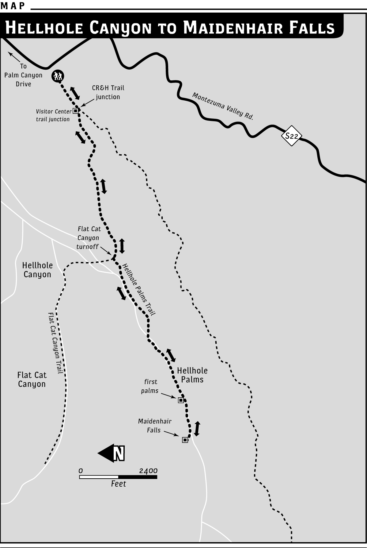
 From the trailhead staging area, move generally southwest toward the mountains, starting on a flat wash of sandy soil through desert chaparral. At around 0.3 miles, reach a split in the trail. Take the right-hand route (the left begins an arduous climb to the Culp Valley Overlook on the California Riding and Hiking Trail). Several yards past this split, you may also notice an ill-defined trail heading north—this leads to the Anza-Borrego Desert State Park Visitor Center, about a mile away.
As you march along, take note of the sounds around you—not much but the crunch-crunch-crunch of your footsteps in the porous desert ground. In the early morning, you might be lucky enough to see a jackrabbit or two darting behind a greasewood bush. Seeing these rabbits is exciting for visiting hikers, but to the Indians living in the area years ago, the rabbits were garden pests. The ocotillo you’ll notice reaching heavenward with its spine- and leaf-lined arms was a useful native plant. By cutting off the long limbs, lining them up around gardens, and watering them, the Native Americans encouraged branches to take root, providing an effective living fence against the hungry jackrabbits that damaged their gardens.
At about 0.5 miles, the trail bears slightly to the right, quickly moving back to its generally southwestern route. The mountain rises on the right, blocking some sunshine and ensuring that Hellhole Canyon remains cooler in the morning hours.
Teddy bear cholla becomes more prevalent, groups piling almost on top of one another to appear like spiny villages. In the afternoon, sunlight glistens over the numerous spines, making the cacti look fuzzy, like a teddy bear.
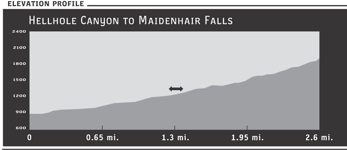
After approximately 1.25 miles, bigger boulders begin to dot the trail, foreshadowing a mile-long section of rock hopping required to reach the falls. At first, the boulders only encroach the trail in spots, providing steps up and down as you progress.
As you move up the canyon, look for topographical evidence of floodwaters on the terrain. The trail comes close to the water-etched washout to the right. A sign warns that this is mountain-lion territory. Be aware of your surroundings, as the possibility of an encounter always exists. A recent visit revealed fresh tracks along the sand wash, but no animal sightings.
You are, however, likely to tangle with catclaws of the plant variety. The wiry stems of this small tree, a member of the acacia family, have feathery leaves and sharp “claws” that grab at clothing and skin.
At a little more than a mile, the trail veers north, with a flat area appearing to continue that direction. If you wanted to hike into adjacent (and extreme) Flat Cat Canyon, you would go that way. Instead, take the narrower trail leading to the left (southwest).
Past the 1.5-mile mark, the trail crosses the channeled-out sand wash, then crosses back again. Watch for the tubular red flowers of the chuparosa, which grow on a gray-green mound-shaped bush. Conserving energy in the arid climate, chuparosa lack leaves during much of the year, but the bright flowers often bloom profusely after rains. The Spanish word chupar means “to suck,” which is what hummingbirds do to the nectar-filled flowers.
With their food source, nectar, present in abundance, hummingbirds are plentiful. In the dense quiet of a desert-canyon hike, listen for the call of the purple-crowned Costa’s hummer. The male’s drawn-out, high-pitched vocalization is surprising, sounding like the whine of a dentist’s drill.
The boulders become bigger and more plentiful and as the well-defined trail ends, some rock hopping begins. A sycamore tree appears, and you’ll spot a few palms ahead in the ravine alongside more sycamores.
The first palm grove is a good place to turn around if you’re averse to boulder hopping. Weigh the effort against what’s ahead—only 0.5 miles remain to reach the falls, which are a delight. As you hike around boulders and up over those that require some climbing, flat sections of trail reappear for short stretches. Pass through areas where water trickles, making its way down the canyon. In the late fall, the sycamore leaves turn a tangerine orange, lighting up the drab, rocky landscape.
When you reach Maidenhair Falls, you’ll recognize it for its namesake. Even when drier weather prevents a heavy pour of water from the approximately 18-foot drop, lacy green ferns cascade down the rock face in abundance. The area surrounding the falls is like a private, shaded garden where few rays of sunlight penetrate the canopy of palm fronds and sycamore leaves. Grapevines grow in a wooded tangle up through the trees, their fleshy leaves hanging in bunches like yellow-green leis. In fact, if led here blindfolded, upon seeing the site you might be momentarily tricked into believing you’d reached a tropical paradise.
Maidenhair Falls is a favorite on hot days after rains when water flows heavily, but a gentle trickle is more relaxing. In the chilly shade of this desert oasis, sit and listen to the constant song of myriad droplets. Even the smaller amounts of water, flowing steadily beneath the exposed rock, pleasantly rumbles like the distant echo of thunder.
Before heading back the way you came, pause and etch the beauty of this natural sanctuary into your mind. This way, on stressful days back in civilization, you can call up the calming image for relaxation.