21 Bow Willow–Rockhouse Canyon Loop
SCENERY: 
DIFFICULTY: 
TRAIL CONDITION: 
SOLITUDE: 
CHILDREN: 
DISTANCE: 8.5 miles round trip
HIKING TIME: 4.5–5 hours
OUTSTANDING FEATURES: Sandy wash, seasonal water, and a historic cattleman’s rock shelter
This trail takes you from the semiprimitive setting of the Bow Willow Campground south into Rockhouse Canyon to glimpse Depression-era relics. You’ll travel from people to solitude and see unusual rock formations as well as a variety of desert vegetation. Brief climbs and descents over varying terrain are interspersed with long, flat treks across sandy washes and open desert. After spring rains, refreshing water gushes through Bow Willow Valley.
Directions: Where CA 78 meets County Route S2 (the Great Overland Route of 1849), head south for 31.2 miles. En route, you’ll see the sign marking your entrance into Anza-Borrego Desert State Park at approximately 4.4 miles. After 21 miles, veer left to continue on S2. A sign marks the Bow Willow Campground at 31.2 miles. Turn right, driving 1.7 miles on this flat, dirt road to the end of the campground, where day-use parking is marked by cut telephone poles lying on their sides.
| GPS Coordinates | 21 BOW WILLOW–ROCKHOUSE CANYON LOOP | |
| UTM Zone (WGS84) | 11S | |
| Easting | 572371 | |
| Northing | 3634168 | |
| Latitude–Longitude | N 32º 50’ 35.4731” | |
| W 116º 13’ 35.9563” |


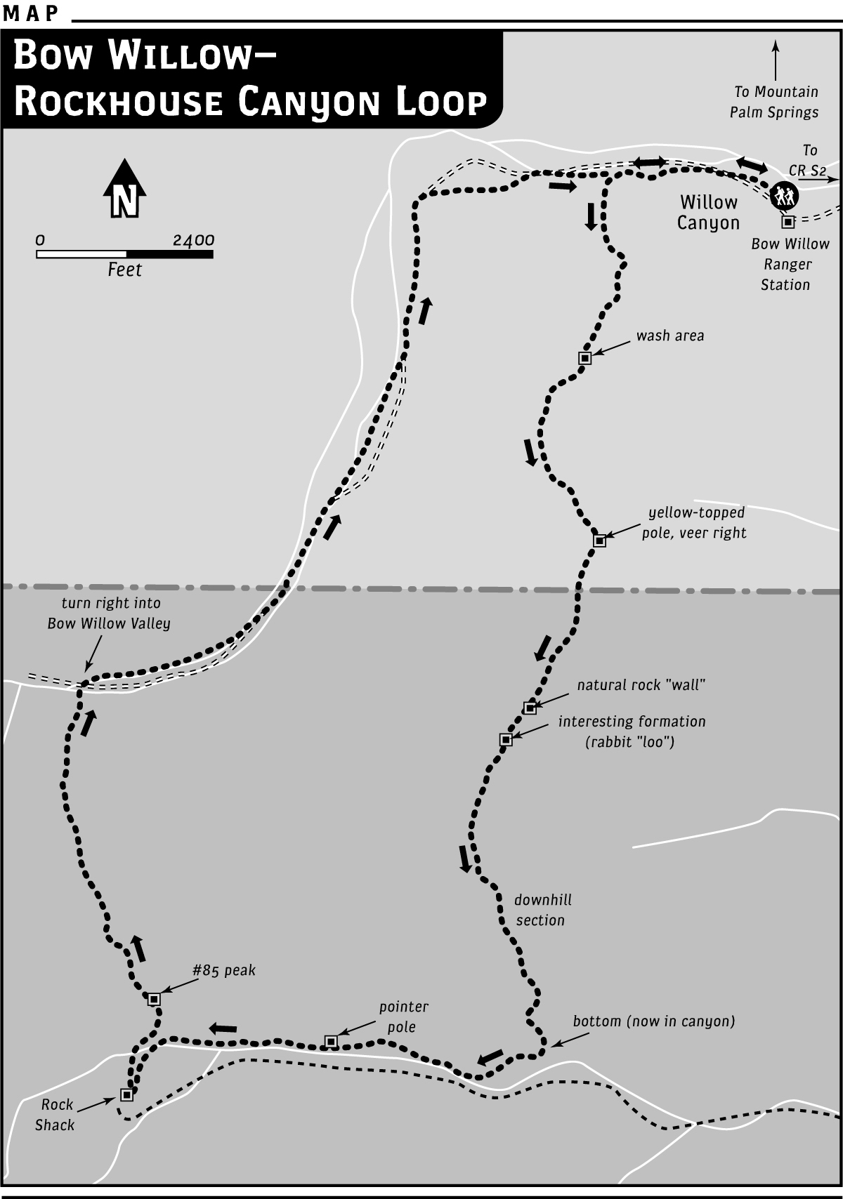
 From the dirt parking areas at the end of the Bow Willow Campground, head northeast, veering almost immediately left (west) into the wide wash of Bow Willow Valley. After about 0.5 miles on flat, sandy terrain, you’ll turn left again, heading into a narrow gorge filled with sweet-smelling desert lilac and red-bloomed chuparosa bushes. After about 0.2 miles, you’ll have to step over some smaller boulders, dodging the grasp of acacia catclaw and passing a single fan palm. The boulders’ sizes and occurrence increase as you move ahead, but the rocks aren’t difficult to work around or over as the path gradually begins to gain elevation. Climb for less than 0.5 miles, then reach flat wash and continue moving southwest.
At 1.6 miles from the trailhead, or 0.6 miles up-wash, you’ll reach a yellow-topped pole marker. Veer to the right here and continue through an area populated by interesting boulder formations and cholla for another 0.5 miles or so. You’ll reach a natural rock “wall” with rock ducks perched atop. Climb over the rocks to the other side. Look for a dilapidated yellow marker just ahead and to the left; beyond this stands a rock grouping that forms a tunnel and a natural courtyard—probably called “the loo” by rabbits, if what’s inside is an indication. From there, the trail is sometimes not so easily identified. Watch for foot-tracks on a route arcing gradually left, and the ever-present rock ducks left by other hikers to guide you.
Approximately 0.25 miles ahead from the “loo,” you’ll enter a rocky downhill divide (still marked by ducks). Be careful of desert apricot, with its narrow branches ending in many pointy spines. At first, this is an easy downhill stroll on evident trail. Boulders soon encroach, though, requiring climbs up and over and perhaps sitting and sliding down the front.
At the bottom of the divide, turn right, walking west on flat terrain thick with prickly cholla. Stay toward the north side of the valley. The idea is to locate a yellow-topped marker pole at 0.5 miles from the turn at the bottom of the divide, then continue on for another 0.5 miles to the second marker. At this point, look for the rockhouse, which rests against the south wall of the canyon and is difficult to spot at first. The easiest way to see the shelter, which tends to blend into the surroundings, is to first look across the canyon and find the metal piping that runs down the south canyon wall. Then locate the rockhouse, which is tucked at the base of the hill, just west of the piping. Once you see it, head directly across (about 0.25 miles) to experience its relic charm.
With a rusty metal roof and piled-rock walls, the small stone shelter is supported by old beams and still holds some metal bedsprings. In one corner you can see the remnants of a fireplace, a humble hearth where a work-weary cattleman may have warmed water or grub. Historical information states that the cabin was built in 1933. The piping hails from a seasonal spring located a short distance up the hill.
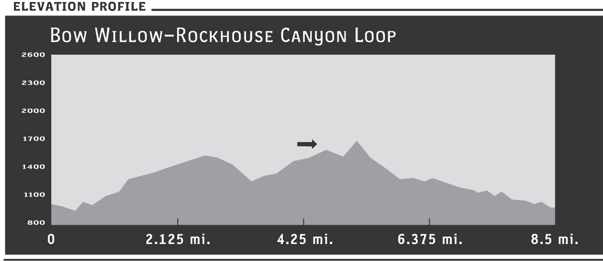
From the rockhouse, the historic highlight of this trek, head back across the canyon to the marker pole, and move west to make your way over the ridge. The route is steep but is only 0.25 miles to the peak and won’t require handholds. Follow the steep and rather slippery zigzag path down the other side, back into Bow Willow Valley. In wetter years, particularly after spring rains, you may find water gushing through the valley. Linger awhile streamside if you like. From here it’s about 3 easy, flat miles east back to the trailhead. In winter, look for clumps of mistletoe growing in bushes and trees, and listen for the soft, single-note call of the phainopepla, which resembles a black cardinal. You may spot the bird’s crested head as it perches for a few moments, resting between its flitting travels to feast upon mistletoe berries.