22 Mountain Palm Springs Loop
SCENERY: 
DIFFICULTY:
TRAIL CONDITION:
SOLITUDE:
CHILDREN: 
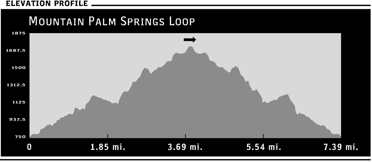
DISTANCE: 7.4 miles round trip
HIKING TIME: 0.5–6 hours
OUTSTANDING FEATURES: Palm oases, sandy wash, seasonal water, and sweeping views of the desert
Six palm groves of varying sizes, two within quick access to the trailhead (which itself is easily reached from County Route S2) make Mountain Palm Springs a visitor favorite. Primitive camping here, and close proximity to more developed Bow Willow Campground just over the hill, also contribute to its popularity. It’s a busy location and you’re likely to see others, especially at the large Southwest Grove, which provides access to 1.5 miles of flat trail from the parking area.
OPTIONS: Overnight stays—primitive camping at Mountain Palm Springs itself or at the Bow Willow Campground (which can be accessed via the Torote Bowl Trail from Southwest Grove). As alternatives to the overview loop route described in detail below, shorter round-trip day hike choices include a northwest trek to and from Mary’s Grove (0.8 miles), a southwesterly walk to and from the Southwest Grove (3 miles), and side trails to explore the Indian Gorge trail and Torote Canyon. The maximum mileage of 7.8 includes Indian Gorge and Torote Canyon in this loop.
Directions: Where Highway 78 meets County Route S2 (the Great Overland Route of 1849), turn right and head south on S2 for 29.4 miles. En route, you’ll see the sign marking your entrance into Anza-Borrego Desert State Park at approximately 4.4 miles. After 21 miles, veer left to continue on S2. A sign marks Mountain Palm Springs at 29.4 miles. Turn right, driving 0.5 miles on the smooth dirt road, past primitive camping turnouts, to parking areas on the right and left.
| GPS Coordinates | 22 MOUNTAIN PALM SPRINGS LOOP | |
| UTM Zone (WGS84) | 11S | |
| Easting | 573096 | |
| Northing | 3636325 | |
| Latitude–Longitude | N 32º 51’ 45.3389” | |
| W 116º 13’ 7.4764” |
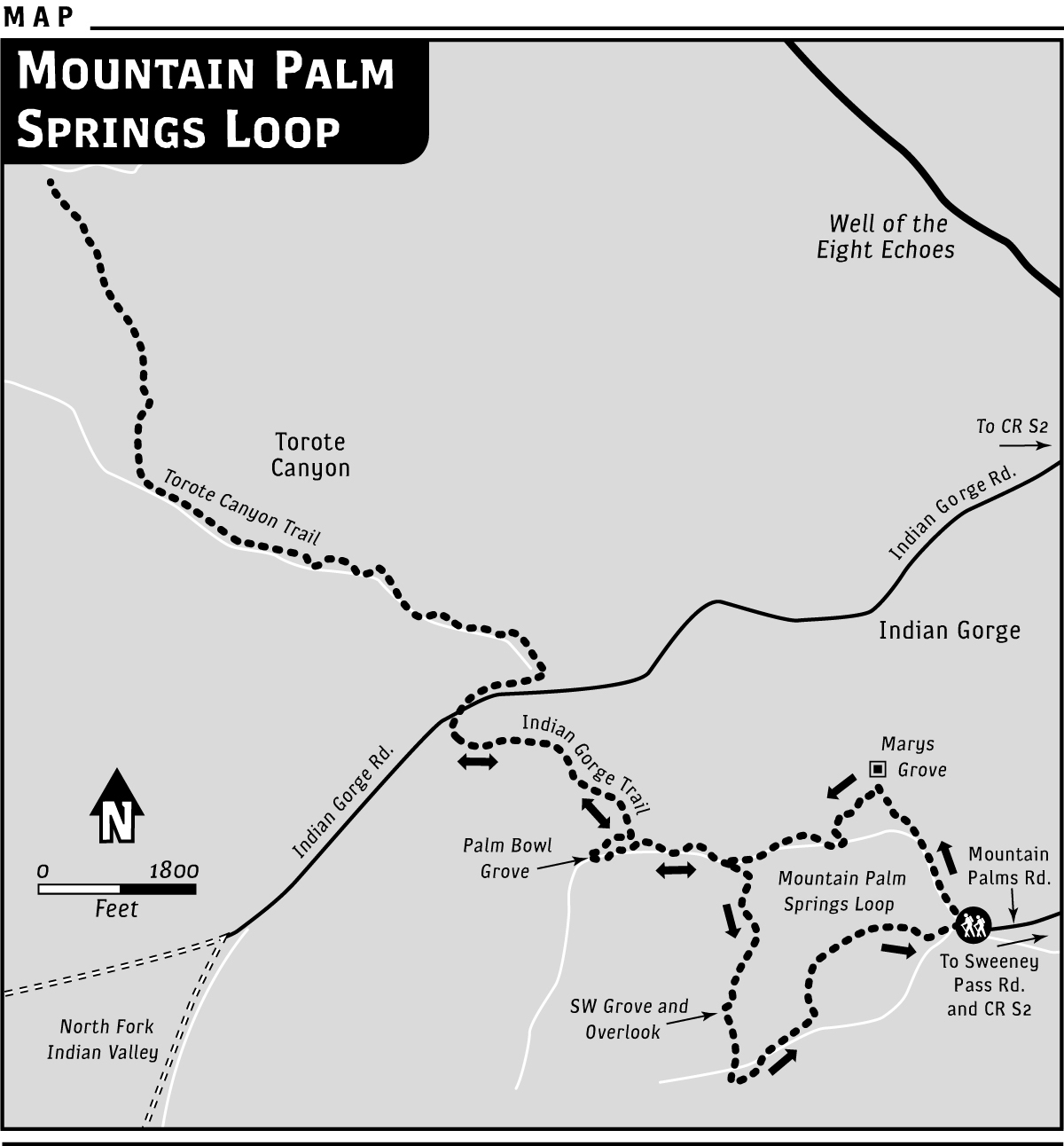
 For a look at all six area palm groves, this loop route begins by heading northwest on a flat sandy wash toward the only palms visible from the parking trailhead (Mary’s Grove). This easy stroll to shady Mary’s Grove makes a wonderful out-and-back option, perhaps as a pleasant break on a long Sunday drive. Seasonal aboveground water flow makes an orchestra of trickling water a possibility. Abundant underground water supports the oases. At about 0.33 miles, you’ll encounter a few boulders that are easily stepped over before you reach the outskirts of this first oasis at 0.4 miles. Explore a little farther along the line of trees in Mary’s Grove, pausing for a while if you wish.
To connect to the loop, turn left almost immediately upon reaching Mary’s Grove (thought to be named for an area store owner) and enter a narrow gorge that hosts a small cluster of palms. Continue along on either side of the palms, up the short gorge to the top of the ridge. From here, find the steep path down into the canyon, careful not to slip on the crumbly soil as you descend. Head right, moving west for about 0.2 miles, and you’ll reach tiny North Grove, which looks like a few straggler palms compared to larger Surprise Canyon Grove already visible ahead.
Continue west and pass by Surprise Canyon Grove, but for the return trip, take note of a narrow trail that begins here, heading up the south side of the canyon. It’s difficult to spot at first, so find the path by looking for rock ducks left by others to mark the route. Leave it for now, and continue up the canyon toward Palm Bowl Grove, about 0.33 miles ahead. This section is thickly overgrown with thorny acacia catclaw. Staying to the left (north) side of the canyon offers the best route, with open paths moving easily through the vicious bushes.
In the winter, you’ll hear the one-note call of the phainopepla here, and possibly see the dark, crested bird flittering among the catclaw. Squirrels scamper about the rocky canyon sides. On my last visit, I startled a large owl that had captured one of the rodents. Clutching its prey, the great bird flew silently to the tops of the palms.
Spend a little time exploring the shady amphitheater delights of peaceful Palm Bowl Grove. Listen for the trickling, echoing sound of ripe berries falling from the treetops, perhaps dislodged by hungry birds. Doves and orioles, as well as coyotes, frequent the cool, food-abundant area.
Next, retrace your steps eastward. To extend the hike outside of Mountain Palm Springs for an introduction to the surrounding area, look for the Indian Gorge Trail, which heads up the north side of the canyon just east of Palm Bowl Grove. Unless you’re searching, you’re not likely to see this trail at all. Careful examination will probably reveal some rock ducks arranged near the base. At one time, the bare stem of a palm frond stood up in the sand to mark the path. Hikers often try to help each other. You may or may not find a definitive marker.
The Indian Gorge Trail itself climbs steeply for about 0.1 mile, then flattens and gradually descends into Indian Valley. The whole stretch of easy trail is 0.5 miles, adding a round-trip mile to the loop. If you have the time and inclination to add another 3.6 miles of hiking, go the short distance across the valley to Indian Gorge Road (dirt), turn right and walk approximately 0.2 miles to the opening of Torote Canyon, and hike its 1.6 miles each way before connecting back with the Indian Gorge Trail and continuing on the Mountain Palm Springs loop.
Back at the base of the Indian Gorge Trail, near Palm Bowl Grove, go left (east), and retrace your steps to Surprise Canyon Grove. Find the trail you located on your first pass, leading up the canyon wall. The narrow trail begins a southwesterly track but quickly veers southeast, steeply climbing on the edge of the canyon wall up to the ridge, then veering southwest (away from the edge) again. The rocky trail through dry landscape is fairly easy to follow for about 0.5 miles; then the Southwest Grove appears suddenly down below. From this tranquil vantage point, the wind sounds like ocean waves as it rustles through the palm leaves.
A narrow, steep trail leads down into the oasis. Be sure to look for the elephant trees as you descend. A large one clings to the canyon wall alongside the descending trail. For a close-up look at these interesting trees with red inner flesh and twisting trunks, consider hiking the Torote Bowl trail. You can access it at the north side of the Southwest Grove. There, a sign marks the trail, which heads upward for 0.5 miles to a grove of the large trees. The Torote Bowl trail connects to another path, descending approximately 1 mile into the Bow Willow Campground.
Once you finish your tour of these desert oases that draw wildlife from the arid surroundings, take the trail from the Southwest Grove leading northeast. It’s approximately 1.5 miles of easy strolling—your feet may get wet in seasonal water flow—to your car. Along the way, you’ll pass through Pygmy Grove, recognized by its smaller palms.