Confluence of the Colorado and Green Rivers
Canyonlands, as its name implies, is an intricate landscape of canyons carved into the Colorado Plateau. Years of erosion have revealed colorful layers of rock and formed buttes and mesas rising high above the Colorado and Green Rivers. Their water continues to carry sediment from the canyon walls and floor all the way to the Pacific Ocean. Controversial conservationist and author, Edward Abbey, described the region best when he wrote that it’s “the most weird wonderful, magical place on earth—there is nothing else like it anywhere.”
He’s absolutely right. Proof lies in the geologic history recorded in layers of rock, and stories passed down over the course of 10,000 years of human inhabitance. Geology meets history at places like Horseshoe Canyon, where pictographs and petroglyphs are etched into the canyon’s walls. Places that weren’t explored or studied until miners in search of uranium fanned out across the labyrinthine canyons.
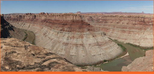
Scientists believe at one time the Colorado Plateau region was completely flat and near sea level before layers of sedimentary rock were deposited. Millions of years ago a series of geologic events, including uplifts and volcanic activity, caused the area to rise more than 5,000 feet, on average, above sea level. This increase in elevation set the stage for the Colorado and Green Rivers to cut their way through soft sedimentary rock, revealing its geologic history in the process. See for yourself in the photograph above. Notice the horizontal bands of rock in the spires and canyon walls. Red and white layers seem to alternate as you move up the geologic column. Red is created from iron-rich deposits carried here by rivers from nearby mountains. White layers are mostly sand left behind from a shallow sea that covered the region millions of years ago. The park’s Upheaval Dome is an anomaly in the geologic order. It’s impossible to be sure what caused this crater-like formation, and scientists continue to debate its origin. Some believe it was formed by a meteorite, while others contend a giant salt-bubble, known as a salt dome, is responsible for the abnormality.
Humans have lived in the region for more than 10,000 years. Artifacts recovered in Horseshoe Canyon date back as early as 9000 – 7000 BC, when mammoths still roamed the American southwest. Pictographs and petroglyphs are also present in the canyon and most notably at its Great Gallery. Ancestral Puebloans and Fremont People left mud dwellings similar in style but much smaller in size than those found at Mesa Verde National Park. It is believed that large populations of Ancestral Puebloans moved into this area around 1200 AD from Mesa Verde, planting maize, beans, and squash, and raising turkeys and dogs.
Paiute and Ute Indians moved in during the tail end of the Ancestral Puebloans’ presence. Neither culture did much exploration of the canyons. They simply used the land to hunt game and gather plants. European Americans arrived in the early 1800s. To fur trappers and missionaries the canyons were nothing more than an impediment to collecting pelts and reaching the west coast. By the 1880s local ranchers used the land as winter pasture. Cowboy camps, like the one visible at Cave Spring Trail in Needles, were established to help safeguard their livestock.
After WWII, the uranium boom hit southeast Utah. Prospectors filed claims all over present-day Canyonlands and nearly 1,000 miles of roads were built thanks to incentives offered by the Atomic Energy Commission. Very little uranium was found, but this new form of exploitation caused concern for Bates Wilson, Superintendent of Arches National Monument. He passionately advocated the creation of a national park, leading jeep tours through the area hoping to gain allies. Fatefully, Secretary of the Interior Stewart Udall joined a tour after peering into the canyons while flying above the Colorado Plateau. He lobbied for the park, and in 1964 legislation was passed and signed by President Lyndon B. Johnson.