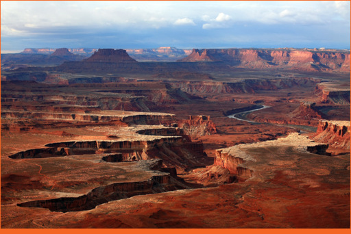
Green River Overlook - Island in the Sky © Shutterstock
Looking at Island in the Sky’s labyrinth of eroded canyons from above may lead you to believe it is utterly impassable. Water found its way across this arid plateau as it carved these canyons, as did park employees, ranchers, prospectors, and ancient inhabitants who spent decades blazing paths across a seemingly impenetrable landscape. Many of their trails are still used today. The park’s most popular trails are well maintained, marked by cairns, and have signposts at intersections. The trails are good, but no reliable water sources exist, so be sure to pack enough for the duration of your hike. One of the most popular trails at Island in the Sky is the easy 0.5-mile loop to Mesa Arch. Its views warrant the popularity. The arch frames distant canyons for unsurpassed photo opportunities (especially at sunrise). A great place to hike into a canyon is Syncline Loop Trail. It’s short enough (8.3 miles) to complete in a day, but you can also turn it into an overnighter thanks to a few spur trails.
Needles District, located on the opposite side of the Colorado River, has equally exciting hiking opportunities. Confluence Overlook Trail is one of the best, a 10-mile (roundtrip) trek that leads in and out of Big Spring Canyon, across Elephant Canyon, before joining a 4WD road. Much of the scenery looks similar and it is possible to lose your way, so look closely for cairns marking the trail. The 4WD road leads to a parking area with a vault toilet. From here you make the final push to the point where sheer canyon walls and the waters of the Green and Colorado Rivers that carved them converge. The hike to Druid Arch is another exceptional journey. You trudge in and out of canyons, crossing several of the area’s hiking trails before Druid Arch stands in front of you at the its end. From this point you can scramble across slickrock for a closer view or return to the trailhead the same way you came.
If you prefer things that are a little more extreme, you’ll enjoy the Maze district, where the average visitor spends three days poking around the extensive network of canyons. A 25-foot length of rope is useful (if not essential) to raise and lower your pack, and a good topographical map is indispensable in the Maze, where side canyons can be difficult to identify and getting lost is easy (as the name implies).
Island in the Sky District
Trail Name | Trailhead (# on map) | Length (Roundtrip distances) | Difficulty/Notes
Gooseneck Overlook | NE corner on White Rim Rd (1) | 1.0 mile | Easy • Views of the Colorado River
Neck Spring | Main Park Road (MPR) near entrance (2) | 5.8 miles | Moderate loop • Ranching evidence and island views
Lathrop | MPR • South of Neck Spring (3) | 22.0 miles | Strenuous • Hike to Colorado River or 13.6 mi to White Rim Rd
Mesa Arch (favorite) | MPR • North of Willow Flat (4) | 0.5 mile Easy loop • Popular self-guiding nature trail
Aztec Butte | MPR • North of Willow Flat (5) | 2.0 miles | Moderate • Ancestral Puebloan granaries
Murphy Point Overlook | MPR • North between Buck Canyon and Candlestick Tower Overlooks (6) | 4.0 miles | Easy • Popular trail with continuous views
Murphy Loop | 11.0 miles | Strenuous • Steep trail descends from the mesa rim
Gooseberry | MPR • White Rim Overlook (7) | 5.4 miles | Strenuous • Shortest route to White Rim Road
White Rim Overlook | MPR • North of Grand View (8) | 1.8 miles | Easy • One of the best views from the island
Grand View Point (favorite) | South end of MPR (8) | 2.0 miles | Easy • Amazing panoramic view of Canyonlands
Wilhite | MPR • West of Willow Flat (9) | 12.2 miles | Strenuous • Slot canyon leads to White Rim Road
Alcove Spring | MPR • Before Upheaval Dome (10) | 11.2 miles | Strenuous • Provides views of Taylor Canyon
Moses and Zeus | Alcove Spring Tr/White Rim Rd (11) | 1.0 mile | Easy • Views of Taylor Canyon and climbing routes
Whale Rock | MPR • Near Upheaval Dome (12) | 1.0 mile | Moderate • Handrails aid crossing steep slickrock
Upheaval Dome | MPR • Upheaval Dome Trailhead (13) | 1.8 miles | Moderate • Popular hike to two overlooks
Syncline Loop (favorite) | MPR • Upheaval Dome Trailhead (13) | 8.3 miles | Strenuous loop • Optional 3 and 7-mile spur trails along route, great for 1-night backpack
Fort Bottom Ruin | NW Corner off White Rim Rd (14) | 4.0 miles | Moderate • An ancient tower ruin
Needles District
Chesler Park Viewpoint | Elephant Trailhead (15) | 6.0 miles | Moderate • Grassland lined with spires (popular)
Chesler Park Loop | Elephant Trailhead (15) | 11.0 miles | Moderate semi-loop • Continue beyond the viewpoint
Druid Arch | Elephant Trailhead (15) | 11.0 miles | Moderate • Scrambling and a ladder, great hike
Confluence Overlook (favorite) | Big Spring Canyon Trailhead (16) | 11.0 miles | Moderate • Outstanding hike to rivers’ confluence
Squaw Canyon | Squaw Flat Loop A (17) | 7.5 miles | Moderate loop • Connects with Big Spring Canyon
Elephant Canyon | Squaw Flat Loop A (17) | 10.8 miles | Moderate semi-loop • Option for several spur trails
Lost Canyon (favorite) | Squaw Flat Loop A (17) | 8.7 miles | Moderate semi-loop • Scrambling and solitude
Peekaboo | Squaw Flat Loop A (17) | 10.0 miles | Moderate • Arch, pictograph, canyons, and (2) ladders
The Maze District: There are no designated trails and no reliable water sources. Come prepared.
Horseshoe Canyon District: There is a 7.5-mile roundtrip hiking trail through the canyon (ancient pictographs).