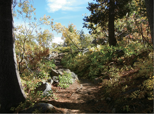
The trail to the summit of Mount Judah begins amid foliage that changes color with the season.
1
Mount Judah
Straddling the crest of the Sierra above Donner Lake, Mount Judah is an easy, accessible peak with summit views that stretch east over Donner Lake and west down the long wooded slopes toward California’s Great Valley.
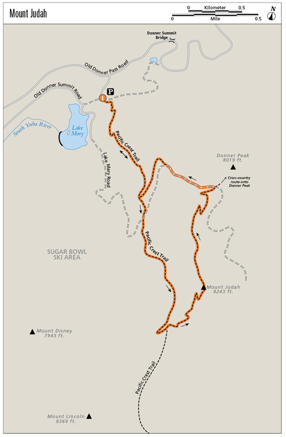
Start: At the Sugar Bowl Academy parking area on historic Donner Summit
Distance: 5.3-mile lollipop
Hiking time: 4–5 hours
Difficulty: Challenging
Trail surface: Dirt singletrack and ski area service roads
Best season: Summer
Other trail users: None
Trailhead amenities: Parking. If the lot is full, park carefully along the dirt road that leads to the trailhead and the Pacific Crest Trail.
Canine compatibility: Leashed dogs permitted
Fees and permits: None
Schedule: You can access the trail from sunrise to sunset daily in late spring, summer, and fall, when the Sugar Bowl Ski Area is not operating.
Maps: USGS Norden CA
Trail contact: Sugar Bowl Resort, 629 Sugar Bowl Rd., Norden, CA 95724; (530) 426-9000; www.sugar bowl.com
Finding the trailhead: From Tahoe City, follow CA 287 northwest to I-80. Head west on I-80 for 12 miles to the exit for Soda Springs and Norden. Head back east on Old Donner Pass Road to the summit of historic Donner Pass. Park in the lot for the Sugar Bowl Academy/Mount Judah. GPS: N39 18.097' / W120 19.570'
The Hike
Gone are the days when ski areas went lifeless after the snow melted in springtime. Now many Tahoe area ski resorts host a variety of summertime activities. Riding mountain bikes down trails that loop around ski runs is perhaps most popular, but other activities include taking gondolas to mountaintop restaurants and activity centers, including hiking trail systems. All this for a fee, of course.
There is no fee, however, to hike up the slopes of the Sugar Bowl ski area to the top of Mount Judah. That might be because this ski area lies farther afield, not on the rim of the Tahoe basin but on the Sierra crest near Donner Pass. Whatever the reason, climbing to the summit and enjoying the views is free to all.
The hike begins with a relatively steep climb up stony switchbacks. Fall color is vibrant along this stretch, and interesting views open at each switchback. This is the lollipop stick part of the route; it also follows a section of the Pacific Crest Trail (PCT).
By the half-mile mark you’ll find yourself looking across the broad ski area bowl onto Lake Mary and west down the I-80 corridor (there is some road noise here, but that fades as you climb away). The climb is a juxtaposition of ski area development and relatively untouched alpine woodland, with traverses through dense forest interspersed with crossings of ski slopes and side trails leading to ski lift stations.
The trail to the summit of Mount Judah begins amid foliage that changes color with the season.
Where the trail forks at 1.1 miles stay right, traveling the loop portion of the route in a counterclockwise direction. At the 2-mile mark reach a junction at a sharp switchback. Bear sharply left on the trail to Mount Judah; the PCT continues right, to Judah’s neighbor Mount Lincoln and beyond.
A series of quick switchbacks and long traverses leads onto and then up along the shoulder of Mount Judah. The views are spectacular and panoramic. Plugs of rock line the trail, conglomerate masses of bulbs and nodes in black and pink that erupt from the slope. The trees grow more stunted, cowed by winter wind and snowfall.
Ski area boundary signs line the trail as you near the summit. The distinctive and aptly named Castle Peak dominates the northern skyline. Round the final switchbacks, passing a pimply rock outcrop, and arrive on the wide, flat, summit plateau, where you can look down upon Donner Lake and into the Martis Lake wildlife area to the east, south along the Sierra crest, and north over the I-80 corridor to Castle Peak and beyond.
Drop through a saddle; a side trail leads to the secondary, northern summit if you choose. To complete the loop, descend on the right-hand trail, dropping swiftly along the northeast-facing slopes of the mountain. If the summit was too windy to permit a lunch break, rock outcrops along the downhill stretch of trail offer perfect rest stops, with views of Donner Lake and Donner Peak.
At the junction with the trail to Donner Peak, continue on the Mount Judah Trail, which leads left. A short section follows an overgrown service road, then the singletrack resumes at an unsigned break to the right. The path drops into a flat, wooded area where you may have to do a bit of route-finding: Cross the water bar and look for a white triangle on a high stump to stay on track. Traverse the mountain’s west-facing slope back to the junction with the PCT, where you’ll close the loop. From there, retrace your steps to the trailhead.
Miles and Directions
0.0Start by walking down the dirt road for about 0.1 mile to the signed trailhead on the left.
0.5Reach the top of the first set of switchbacks.
0.8Pass a ski area sign (with skull and crossbones) that urges you to ski back to the lift. Not an issue, of course, for hikers in the off-season.
1.1Cross a streamlet, then traverse a ski slope. At the trail junction stay right, remaining on the Pacific Crest Trail (PCT) to complete the loop section in a counterclockwise direction.
1.25Cross a service road, picking up the obvious trail on the other side.
1.5A side trail breaks off to a ski lift station. Stay left, continuing uphill.
2.0At the trail junction, bear sharply left to continue on the Mount Judah Trail. The PCT continues to the right.
2.75Arrive on the summit plateau. Begin the descent by heading north along the ridgeline.
2.9At the north end of the saddle, the trail splits. The left path leads to the northern summit; go right to begin the descent.
3.5At the junction with the trail to Donner Peak, go left on the Mount Judah Trail.
4.0After a brief walk on an overgrown roadway, take the unsigned but obvious trail that breaks right. Drop into a flat, wooded area; stay left and cross the water bar. A white triangle on a high stump marks the route.
4.3Reach the junction with the PCT to close the loop portion of the lollipop.
5.3Arrive back at the trailhead.
Hike Information
Local information: Soda Springs and Norden, while supporting a healthy winter recreational industry, are small and primarily residential in summer. Truckee is the nearest large town. The Truckee Donner Chamber of Commerce and California Welcome Center are at 10065 Donner Pass Rd., Truckee, CA 96161; call (530) 587-8808; www.truckee.com. The chamber website is www.truckeechamber.com.
Local events/attractions: Sugar Bowl Ski Resort hosts summer camps for kids. Contact the resort at (530) 426-9000 or visit www.sugarbowl.com for more information.
Camping: Donner Memorial State Park offers camping during the summer months. The park’s 123 sites are equipped with metal bear boxes, where all food should be stored. Some sites are suitable for RVs, but they cannot exceed 28 feet in length. Campers have access to all park facilities. A fee is charged. For more information call (530) 582-7892. Online reservations can be made by visiting the Donner Memorial State Park page at www.parks.ca.gov; the link will take you to the park’s ReserveAmerica (www.reserveamerica.com) page.