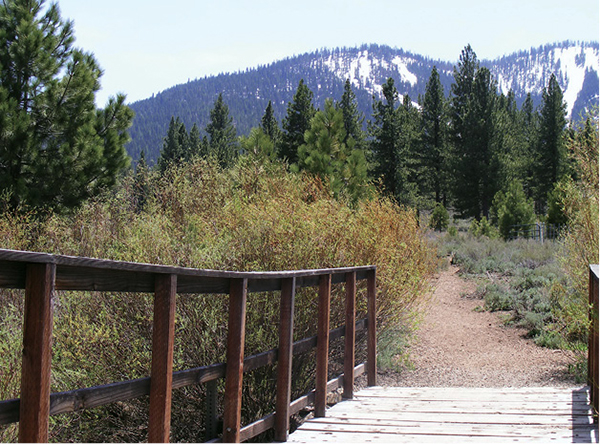
Dedicated bridges span meandering Martis Creek.
4
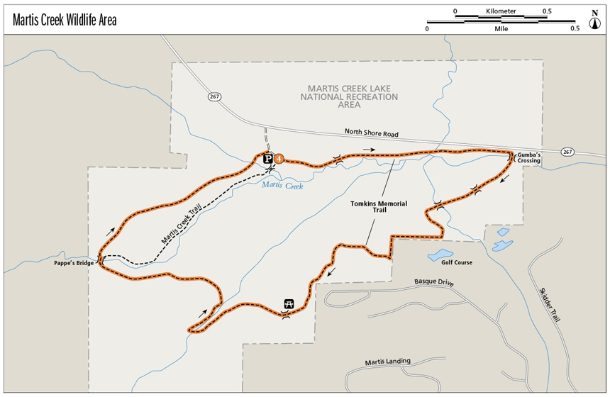
Martis Creek Wildlife Area
The Martis Valley holds the biggest expanse of meadow and marshland in the Tahoe area. Birds flourish on the landscape, chirping, flitting, and soaring over winding Martis Creek. Whether you like birds or not, this exploration of the enormous grassland is enlivening.
Start: At the Martis Creek trailhead off CA 267 between Truckee and the base of Brockway summit
Distance: 4.2-mile loop
Hiking time: 2–3 hours
Difficulty: Moderate
Trail surface: Dirt singletrack, boardwalk
Best seasons: Late spring, summer, fall
Other trail users: Trail runners, mountain bikers on the Tomkins Memorial Trail (not permitted on the Martis Creek Trail)
Trailhead amenities: Parking, restrooms, picnic facilities, informational signboards
Canine compatibility: Leashed dogs permitted on the Tomkins Memorial Trail. Please pick up after your pet; bags are provided at the trailhead. Do not leave bags along the trail.
Fees and permits: None
Schedule: Sunrise to sunset daily
Maps: USGS Martis Peak CA and Truckee CA; maps are also posted at the trailhead and along the route.
Trail contact: US Army Corps of Engineers, PO Box 2344, Truckee, CA 96161; (530) 587-8113; corpslakes.usace.army.mil/visitors/martiscreek
Special considerations: The fragile Martis Creek Trail has been damaged by overuse; tread lightly or avoid it by remaining on the Tomkins Memorial Trail. The Martis Creek route passes through an important heritage area for the Washoe Indians. Removal of artifacts or damaging historic or prehistoric sites is prohibited by law.
Finding the trailhead: From the signalized junction of CA 28 and CA 267 in Kings Beach, follow CA 267 for 8.3 miles, over Brockway summit, to the signed Martis Creek Wildlife Area turnoff on the left (south). Follow the gravel access road for 0.1 mile to the trailhead. From I-80 in Truckee, take exit 188B and head south for 3 miles, past the main entrance for Martis Creek Lake, to the trailhead access road on the right. Parking is limited; if spaces are full, park along the access road or visit another day. GPS: N39 18.096' / W120 07.840'
The Hike
Martis Creek wanders through acres and acres of wetland meadow, cutting deeply into the turf, bending in sharp oxbows, watering a springtime bloom of wildflowers, and providing sustenance for a variety of creatures.
The birds are most prominent, their songs loud enough to be heard over the purr of cars passing on the nearby highway. Songbirds flit from willow to rose to sedge in flashes of brown, black, red, yellow, and sometimes vivid blue. Watch for raptors stilling in the clear mountain air and swallows shooting in and out of the shelter of the highway underpass. Fish, amphibians, and mammals, from ground squirrels to foxes to black bear, also visit or call the wildlife area home.
The Tomkins Memorial Trail arcs through the sanctuary in a long loop that first immerses hikers in the meadow ecosystem. It then leads into the evergreen forest that cloaks the slopes of the Lookout Peak, Northstar’s ski mountain. The meadowland has known human habitation for 10,000 years or more and is presently hemmed in by the ski resort community, so you’ll never be far from signs of civilization, be it the golf course, private homes, or the occasional airplane approaching or leaving the regional airport.
Dedicated bridges span meandering Martis Creek.
The Tomkins Memorial Trail loop is described clockwise. The trail parallels the highway at the outset, following a broad track easily shared with other trail users. At one of many named bridges spanning the wandering creek and its tributaries, the trail breaks south toward the Northstar resort, traversing sometimes soggy meadow via boardwalks and singletrack.
The metal roofs of private homes glint through the trees as you approach the base of the ski mountain. The trail curves west along the edge of the golf course, then through the forest at the bottom of the ski area. A brief foray into the woodland ends back in the meadow, where the Tomkins Memorial Trail links to the Martis Creek Trail.
According to its caretakers, the track along Martis Creek, a one-time cattle path, has been loved to near oblivion. Though it is possible to follow the trail along the meandering creek back to the trailhead, you will do the meadow good by finishing your tour via the Tomkins Trail, using a boardwalk and well-maintained path to circle back to the starting point. A bench along this final stretch offers hikers a chance to rest and enjoy views across the creek and valley. The Tomkins Trail meets the Martis Creek path below the parking area; a short easy climb leads out of the bottomlands and back to the trailhead.
Miles and Directions
0.0Start on the signed Tomkins Memorial Trail, following the broad path that parallels the highway.
0.5Cross Frank’s Fish Bridge, the first of many named spans.
0.8Reach Gumba’s Crossing. Cross the bridge, then head southeast across the boardwalk.
1.0Cross the Green Team’s Bridge, then the Broken Bridge.
1.4Pass under power lines and curl north as the trail runs along the fenced boundary between the wildlife area and the golf course.
1.6 At a break in the fence, marked by a trail sign, go right (north) to continue the loop. The left-hand path leads up into the neighborhood.
1.9Pass a picnic table shaded by massive twin Jeffrey pines, then cross Michael Cousin’s Bridge.
2.2Now in the woodland, pass several junctions with social trails leading back into the neighborhood. Stay right (southwest) at the junctions on the obvious Tomkins Memorial Trail.
2.6A picnic table and trail map at the edge of a small meadow mark a sharp turn in the trail.
2.9Reach a bench at the interface between meadow and woodland.
3.1Pass through scrubland to another trail sign. Ignore side trails, staying straight (west) on the broad main track.
3.3Arrive at Pappe’s Bridge, with a picnic table and a trail sign. The Tomkins Memorial Trail continues straight (west) via a boardwalk; continue on this track. The signed Martis Creek Trail breaks to the right (north).
4.1Meet the Martis Creek Trail below the trailhead and climb toward the parking area.
4.2Arrive back at the trailhead.
Hike Information
Local information: The Truckee Donner Chamber of Commerce maintains an online database of information about the mountain town, including where to eat, where to stay, and local events. Visit the site at www.truckee.com, or contact the chamber by calling (530) 587-8808. The mailing address is 10065 Donner Pass Rd., Truckee, CA 96161.
Local events/attractions: Martis Creek Lake, run by the US Army Corps of Engineers and located across the road from the Martis Creek trailhead, offers a variety of outdoor activities, including boating, fishing, camping, picnicking, and cross-country skiing and snowshoeing in winter. Call (530) 587-8113 (Apr–Nov) or (530) 432-6427 (Dec–Mar), or visit www.spk.usace.army.mil/Locations/SacramentoDistrictParks/MartisCreekLake.aspx.
Camping: The Army Corps of Engineers maintains a campground across (north of) CA 267 from the wildlife area. Twenty-five campsites at the Alpine Meadows Campground are available on a first-come, first-served basis. Campsites are outfitted with tables, fire rings, grills, water, and restrooms. Two campsites are handicapped accessible and available by reservation; call the park ranger at (530) 587-8113. The campground is open from approximately May 15 to Oct 15, weather permitting.
Green Tip:
Avoid sensitive ecological areas. Hike, rest, and camp at least 200 feet from streams, lakes, and rivers.