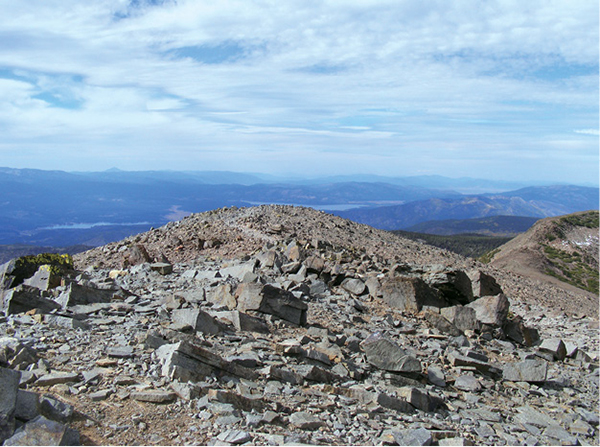
The views northeast from the summit of Mount Rose stretch across the Truckee Meadows into Nevada's basin and range.
5
Mount Rose
Panoramic views from the summit of Mount Rose reach north and east across Truckee Meadows into the basin and range of Nevada, and south and west across Lake Tahoe into the highlands of Sierra Nevada. It’s a climb, but every step is worth it.
Start: The trailhead at the summit of the Mount Rose Highway (NV 431)
Distance: 9.6 miles out and back
Hiking time: 6–7 hours
Difficulty: Strenuous
Trail surface: Dirt singletrack
Best seasons: Summer, early fall
Other trail users: None
Trailhead amenities: Parking, restrooms, picnic facilities, trashcans, informational signboards
Canine compatibility: Leashed dogs are permitted on the lower sections of trail; dogs must be on leash within 1 mile of the trailhead. Dogs are permitted in the Mount Rose Wilderness; owners must keep them under control and clean up their waste.
Fees and permits: None
Schedule: Sunrise to sunset daily
Maps: USGS Mount Rose NV
Trail contact: US Forest Service, Lake Tahoe Basin Management Unit, Forest Supervisor’s Office, 35 College Dr., South Lake Tahoe, CA 96150; (530) 543-2600; www.fs.fed.us/r5/ltbmu. Humboldt-Toiyabe National Forest, Carson Ranger District, 1536 S. Carson St., Carson City, NV 89701; (775) 883-2766; www.fs.usda.gov/htnf
Special considerations: The summit of Mount Rose is at 10,776 feet. If you experience any symptoms of altitude sickness, descend immediately. Pay close attention to the weather: If thunderstorms are predicted, choose another day to hike. If storms threaten, retreat to the safety of your vehicle.
Other: The parking lot can be crowded and/or full on busy summer days. If you must, park carefully alongside the highway. An alpine start (early departure) is recommended, both to secure safe parking and to avoid the possibility of inclement weather.
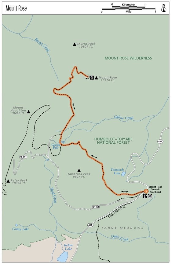
Finding the trailhead: From the junction of NV 28 and NV 431 (the Mount Rose Highway) in Incline Village (at the roundabout), go north on NV 431. Travel the scenic highway for 8 miles to the summit parking area. The trailhead is located behind the restrooms and informational signboards. GPS: N39 18.790' / W119 53.859'
The Hike
Whether your base is in Reno or Tahoe, bagging the summit of Mount Rose is a necessary and relatively easy peak experience. It is among the highest ramparts of the Carson Range and with its neighbor, Slide Mountain, is an iconic element of Reno’s mountain backdrop.
Strong legs, lungs, and willpower are prerequisites for this hike, which ascends nearly 2,000 feet from trailhead to apex. The summit is at more than 10,000 feet, so acclimation to altitude is also a prerequisite. If you bring a filter, you can get water at Galena Creek, but you should carry all you need.
Aside from a feeling of accomplishment, the summit of Mount Rose offers as reward a 360-degree viewscape that reaches into the Great Basin of Nevada, scans the rolling forested summits of the northern Sierra, and stretches across the expanse of Lake Tahoe, with the silvery peaks of the high Sierra shimmering on the southern horizon. You could call it breathtaking, but your breath will already have been lost on the final approach, sucked away by wind and altitude.
The hike begins with an easy, relatively flat traverse on a section of the Tahoe Rim Trail (TRT), skimming the flanks of Tamarack Peak. Views sprawl south across marshy Tahoe Meadows and down to the lake. Highway noise drifts up to the route, but once you top a knoll and begin to hike along northeast-facing slopes through the woods, you won’t be able to discern the hum of engines from the wind ruffling the treetops. Openings in the woods allow great views down steep ravines into the Truckee Meadows.
The views northeast from the summit of Mount Rose stretch across the Truckee Meadows into Nevada's basin and range.
The trail has a distinctly wild feel by the time you reach the junction of the TRT to Relay Peak and the trail to the summit of Mount Rose. Galena Falls spill down a steep rock face along willowy Galena Creek, and the meadow widening to the northeast blooms with wildflowers in spring and summer. This is an excellent turnaround spot for those not interested in attempting the peak.
To continue, bear right on the Mount Rose Trail, crossing the creek and beginning the climb up the pale pink slopes. Set your pace and plow on; there are no trail junctions from here to the top. Taking breathers is not a problem, given that nearly every stopping point boasts a great view. A saddle, where you’ll cross into the Mount Rose Wilderness, offers a brief respite of relatively flat ground. Then the trail trends eastward and uphill along a ridge crest, with views alternating down into the high desert and out across the high Sierra to the south.
By the 4.5-mile mark you are above treeline. The views are panoramic, with the lake basin sparkling to the south. Push up the naked, often wickedly windy final stretch of trail to the rocky summit, where blocks of granite offer places to shelter for a quick bite and to pose for pictures with Tahoe in the background.
Return as you came. You’ll find this a different trail on the return, with different views and different challenges. Take your time and enjoy.
Though the genesis might be different, the distinctively pinkish hue of this extinct volcano’s slopes makes Mount Rose an apt name. Another apt name: The Bloody Rose, which is the moniker of an annual mountain bike event featuring more than 12 miles of climbing on dirt roads and singletrack.
Miles and Directions
0.0Start at the Mount Rose trailhead at the summit parking area on NV 431, following the Tahoe Rim Trail and the signed trail to Mount Rose.
0.1At the trail Y (the junction of the Tahoe Rim Trail heading south into Tahoe Meadows), go right (up the stairs) on the Mount Rose Trail.
0.5Top a knoll and check out the views south across Lake Tahoe and northeast into the Truckee Meadows and Washoe Valley.
1.4Round a knob with views of a lumpy wooded ridge.
2.4Reach the junction of the TRT to Relay Peak and the trail to Mount Rose. Galena Falls is also at this juncture. Go right on the signed trail to the Mount Rose summit.
2.7After crossing a scree field, reach a second junction with the TRT to Relay Peak. Remain on the summit trail.
3.3Cross a tributary stream; the climb continues in the drainage.
3.75Reach a saddle/pass and pass the signs denoting the Mount Rose Wilderness and Toiyabe National Forest boundaries. The trail continues to the right and is signed for the Mount Rose Summit.
4.5Just below treeline, a small cluster of krummholz crowds the trail.
4.8Reach the summit. Enjoy the views, then return as you came.
7.6Return to the junction with the TRT to Relay Peak at Galena Falls.
9.6Arrive back at the trailhead.
Hike Information
Local information: Information about businesses, restaurants, and activities in North Lake Tahoe, including Incline Village and Crystal Bay, can be found at www.gotahoenorth.com. The Incline Village General Improvement District is another good resource. The IVGID administrative office is at 893 Southwood Blvd., Incline Village, NV 89451; call (775) 832-1100 or visit ivgid.org.
Local events/attractions: The Mount Rose Ski Area, which is on the Reno side of the pass and actually located on Slide Mountain, offers lift-served chutes, groomers, and a snow park for winter fun. The address is 22222 Mount Rose Hwy. (NV 431), Reno, NV 89511. Call (775) 849-0704 (in Nevada) or (800) SKI-ROSE (outside Nevada); www.skirose.com.