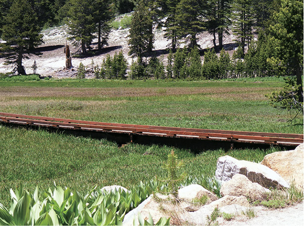
Boardwalks enable trail users in Tahoe Meadows to avoid the mush of the marshes surrounding Ophir Creek and its tributaries.
6
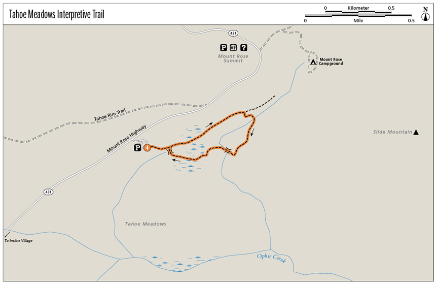
Tahoe Meadows Interpretive Trail
Meandering through a lovely meadow beneath the summits of Slide Mountain and Mount Rose, this flat, friendly interpretive route is perfect for families, wildflower enthusiasts, and view seekers.
Start: At the signed trailhead in the parking lot on the east side of the Mount Rose Highway (NV 431)
Distance: 1.3-mile lollipop
Hiking time: 1 hour
Difficulty: Easy
Trail surface: Dirt singletrack
Best seasons: Summer and fall
Other trail users: None
Trailhead amenities: Parking, restrooms, information signboards. If no parking is available in the good-size lot, park in the pullouts/on the shoulder of NV 431.
Canine compatibility: Leashed dogs permitted
Fees and permits: None
Schedule: Sunrise to sunset daily
Maps: USGS Mount Rose NV
Trail contact: US Forest Service, Lake Tahoe Basin Management Unit, Forest Supervisor’s Office, 35 College Dr., South Lake Tahoe, CA 96150; (530) 543-2600; www.fs.fed.us/r5/ltbmu. Tahoe Rim Trail Association, 948 Incline Way, Incline Village, NV 89451; (775) 298-0233; www.tahoerimtrail.org. Humboldt-Toiyabe National Forest, Carson Ranger District, 1536 S. Carson St., Carson City, NV 89701; (775) 883-2766; www.fs.usda.gov/htnf
Other: This was formerly known as the Tahoe Meadows Whole Access Trail. The route is wheelchair and stroller accessible for the first 0.5 mile.
Finding the trailhead: From the roundabout in Incline Village at the junction of NV 28 and NV 431 (the Mount Rose Highway), go right (northeast) onto NV 431 for 7.3 miles to the signed trailhead on the right (east). GPS: N39 18.433' / W119 54.436'
The Hike
Easy and scenic, the Tahoe Meadows Interpretive Trail explores stands of stately evergreens and a verdant meadow filled with wildflowers in season. The trail is at nearly 8,700 feet and features vistas of high ridges stretching south to Lake Tahoe, as well as up-close views of the stony summits of Slide Mountain and Mount Rose to the east.
The first part of the trail is accessible to hardy wheelchair users. Families with small children, whether in a stroller, a backpack, or toddling, can manage the entire loop. While paved trails on the shores of Lake Tahoe provide miles of opportunity for the wheelchair-bound to enjoy the great outdoors, this interpretive trail is the best “off-road” option. Though the Mount Rose Highway, a lovely and popular drive, is never distant, the scenery more than qualifies this as an alpine experience. And because of the altitude and depending on the winter’s snowfall, the trail may hold snow into midsummer.
A trail sign behind the restroom marks the hike’s start. Follow the well-groomed dirt track into the meadow; at an interpretive sign and boardwalk/bridge, the trail splits, forming a loop. Stay left (north), as the signs indicate, traveling the loop in a clockwise direction.
Boardwalks enable trail users in Tahoe Meadows to avoid the mush of the marshes surrounding Ophir Creek and its tributaries.
Though this section of the Tahoe Rim Trail gently climbs, the pitch is not strenuous. The path merges onto a patch of pavement, then reverts to natural surface as it traces the edge of the meadow. A pocket of altitude-stunted evergreens briefly blocks the meadow views, then the route traces the interface of forest and grassland as it approaches the head of the meadow.
Diverge from the Tahoe Rim Trail, which continues north and west toward Mount Rose, at a trail sign. Stay right (east) on the nature trail, curving south toward the Lake Tahoe basin and winding through a mature upper montane woodland. Interpretive signs along this stretch describe frogs and fish, butterflies and birds, human habitation and hibernation. Bridges span the meandering stream, and tiny fish that somehow survive and thrive at these heights dart through the dark, clear water.
The trail leaves the forest and proceeds across small bridges and boardwalks in the moist, sometimes buggy meadow. Views open into a blue void to the south: nothing but a bowl of sky, with the vast lake 2,000 feet below and out of sight.
Close the loop at the bridge and trail sign, then retrace your steps back to the trailhead.
Miles and Directions
0.0Start at the information sign.
0.1The trail splits at an interpretive sign and bridge; take the left leg as directed by the trail sign, traveling in a clockwise direction.
0.5Reach the intersection with the Tahoe Rim Trail, which continues north and west toward Mount Rose. Go right (east) on the interpretive trail.
0.8Pass a trail marker and cross a bridge over the stream.
1.2Close the loop at the trail junction.
1.3Arrive back at the trailhead.
Hike Information
Local information: Information about businesses, restaurants, and activities in North Lake Tahoe, including Incline Village and Crystal Bay, can be found at www.gotahoenorth.com. The Incline Village General Improvement District is another good resource. The IVGID administrative office is at 893 Southwood Blvd., Incline Village, NV 89451; call (775) 832-1100 or visit ivgid.org.
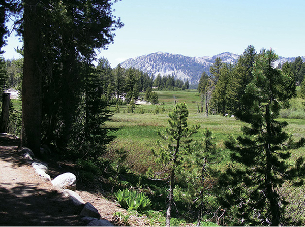
The Mount Rose Wilderness forms the backdrop for the easy interpretive trail through Tahoe Meadows.
Green Tip:
Carry a reusable water container that you fill at the tap. Bottled water is expensive, lots of petroleum is used to make the plastic bottles, and they’re a disposal nightmare.