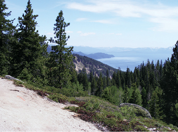
Views of Lake Tahoe appear through breaks in the trees at the top of the Incline Downhill.
7
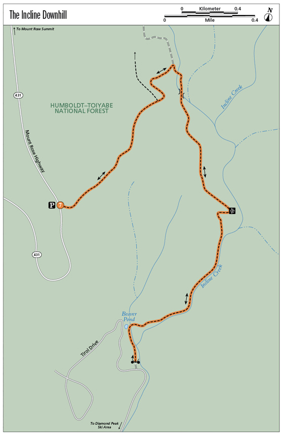
The Incline Downhill
The Incline Downhill is popular with hikers and mountain bikers, offering access to lovely views, a rollicking stream, and a thigh-pumping descent and ascent.
Start: From the gated trailhead along the Mount Rose Highway (NV 431)
Distance: 2.75-mile shuttle; 5.5 miles out and back
Hiking time: 1–2 hours one way; 2–3 hours out and back
Difficulty: Moderate
Trail surface: Dirt singletrack
Best seasons: Summer, fall
Other trail users: Mountain bikers, trail runners
Trailhead amenities: Limited parking at the trailhead; more parking available across the Mount Rose Highway in a large, paved, roadside pullout
Canine compatibility: Dogs are permitted
Fees and permits: None
Schedule: 24 hours a day, 7 days a week, year-round
Maps: USGS Mount Rose NV and Marlette Lake NV
Trail contact: US Forest Service, Lake Tahoe Basin Management Unit, Forest Supervisor’s Office, 35 College Dr., South Lake Tahoe, CA 96150; (530) 543-2600; www.fs.fed.us/r5/ltbmu
Finding the trailhead: From the junction of NV 28 and NV 431 in Incline Village, follow the roundabout onto NV 431 and head up toward the Mount Rose summit. The trailhead is on the right at the 3.9-mile mark, just above the scenic overlook. GPS: N39 16.115'/ W119 55.835'
The Hike
Views of Lake Tahoe are framed by pines and firs at the top of the Incline Downhill. On the lower section it’s a different picture: The path is wedged between a canyon wall and Incline Creek, which sprints toward the lake through a shady riparian zone.
This hike is described upside down, starting with the descent and ending with the ascent. It can be traveled in the other direction if you have access to parking on Tirol Drive or don’t mind walking to the trailhead from the Diamond Peak Ski Resort parking lot. Starting on the verge of NV 431 eliminates the short stretch of street and virtually guarantees parking. Doing the hike as a shuttle is an option as well.
Starting from the Mount Rose Highway trailhead, the route begins with a traverse along a section of trail that follows the historic Incline Flume. The grade is gentle and the path meandering, with views of the lake at nearly every turn. As you drop toward the Incline Creek draw, the trail splits several times; at the first Y take the high track to the left, and at the second and third junctions stay right, crossing a stream that waters a lovely little meadow via a small plank bridge. Where trails merge just beyond the bridge stay straight and enjoy the views as you begin the snaking descent.
Views of Lake Tahoe appear through breaks in the trees at the top of the Incline Downhill.
Round a sharp curve (a side trail breaks left to an overlook rock), and the trail enters the Incline Creek drainage. The pitch is relatively steep and the trail surface a bit rocky as you trace the creek downhill. Riparian growth—dogwood, willow, and alder—provide ample shade, with evergreens towering above. In early season look for distinctive red snow plant on the forest floor.
By the 2.5-mile mark you’ve completed the downhill. Cross the stream and follow the track, which widens to road width, as it continues behind neighborhood homes. A beaver pond is trailside a bit farther along, outfitted with a beaver deceiver (a beaver-friendly device that helps control flooding near beaver ponds). This makes a lovely spot for a break before the climb back to NV 431.
The trail formally ends at a chain blocking access from Tirol Drive. If you’ve left a shuttle car in the Diamond Peak Ski Area parking lot, follow Tirol Drive downhill to the resort. Otherwise, return as you came.
Tahoe’s famous Flume Trail, a must-do for many mountain bikers, lies farther south on the lake’s East Shore. Mountain bikers have access to the section of the Tahoe Rim Trail between the Flume Trail at Marlette Lake and the Mount Rose summit on even calendar days.
Miles and Directions
0.0Start by walking down the broad dirt track. After about 300 feet stay left and begin the traverse.
0.7At the unsigned trail junction stay left, on the high track, with a meadow below on the right.
0.9At the Y, go right and down on the unsigned trail.
1.0Cross a stream, then stay right at the trail split. Cross the stream again on a little bridge.
1.1Where unsigned trails merge, stay straight (left). The downhill begins.
2.0The trail parallels Incline Creek as it descends.
2.5Cross the creek and enter the neighborhood.
2.6Pass the beaver dam.
2.75Reach trail’s end at the chain and Tirol Drive. Follow Tirol Drive down to shuttle parking at Diamond Peak Ski Resort, or retrace your steps.
5.5Arrive back at the trailhead.
Hike Information
Local information: Information about businesses, restaurants, and activities in North Lake Tahoe, including Incline Village and Crystal Bay, can be found at www.gotahoenorth.com. The Incline Village General Improvement District is another good resource. The IVGID administrative office is at 893 Southwood Blvd., Incline Village, NV 89451; call (775) 832-1100 or visit ivgid.org.
Restaurants: For a sophisticated meal on the shore of Lake Tahoe in Incline Village, try the Lakeside Beach Bar and Grill at the Hyatt Regency. Fresh seafood and creative salads are on the menu. The grill is at the junction of Country Club Drive and Lakeshore Boulevard; call (775) 832-1234 for more information.
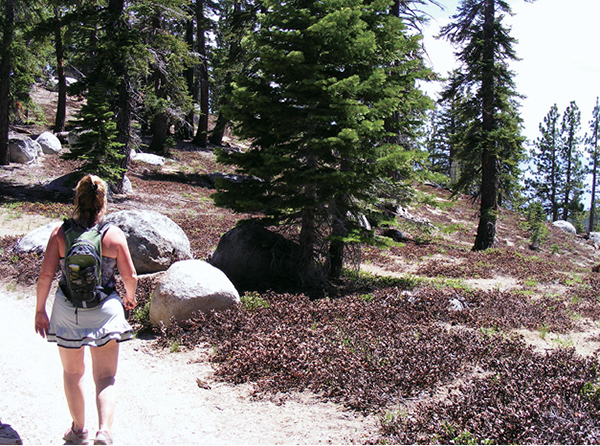
A hiker enjoys the views from the Incline Downhill—as well as the ease of the descent.
Green Tip:
Car shuttles on point-to-point hikes add to the carbon load; loop hikes just take foot power.