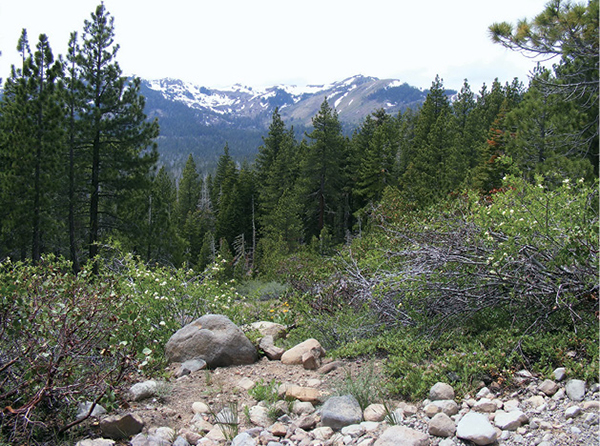
The section of Tahoe Rim Trail that leads to Page Meadows offers fleeting views of the peaks at the head of Ward Creek.
10
Page Meadows
Page Meadows hosts one of the best wildflower blooms in the basin. It greens up by late May, glows with color by late June, and remains a restful, scenic destination through the rest of the hiking season. A steady climb on the Tahoe Rim Trail leads to the meadows.
Start: At the signed trailhead on Ward Creek Boulevard
Distance: 3.3 miles out and back
Hiking time: 2 hours
Difficulty: Moderate
Trail surface: Singletrack and logging road
Best seasons: Late spring and early summer for the wildflower bloom
Other trail users: Mountain bikers, equestrians, off-road vehicles on adjacent trails
Trailhead amenities: Parking alongside Ward Canyon Boulevard, an informational signboard with maps
Canine compatibility: Dogs permitted
Fees and permits: None
Schedule: Dawn to dusk daily
Maps: USGS Tahoe City CA; Tahoe Rim Trail map for the Barker Pass to Tahoe City section available at the trailhead and online
Trail contact: US Forest Service Lake Tahoe Basin Management Unit, Forest Supervisor’s Office, 35 College Dr., South Lake Tahoe, CA 96150; (530) 543-2600; www.fs.fed.us/r5/ltbmu. Tahoe Rim Trail Association, 948 Incline Way, Incline Village, NV 89451; (775) 298-0233; www.tahoerimtrail.org
Finding the trailhead: From Tahoe City follow CA 89 south toward Homewood to Pineland Drive (with large pineland signs). Turn right (west) onto Pineland Drive and go 0.3 mile to Twin Peaks Drive, where a sign points you toward Ward Valley. Go left (south) onto Twin Peaks, then quickly right (west) onto Ward Creek Boulevard. Follow Ward Creek Boulevard for 1.5 miles to the signed Tahoe Rim Trail trailhead. Park carefully on the roadside. GPS: N39 08.435' / W120 11.522'
The Hike
High country wildflower displays are understated, flowers blooming modestly in patches that mingle with meadow grasses. Some varieties, like mule ears with their bright yellow sunflower-like flowers and the tall white umbrellas of cow parsnip, border on flamboyance, but most flourish low to the ground, their subtle beauty best appreciated upon close inspection.
Page Meadows, situated above the Ward Valley at about 7,000 feet, is the perfect destination for the wildflower or mountain meadow lover. Rimmed by a thick evergreen forest with a lacy edge of aspens that have been sculpted into a tangle by winter snows, the meadow blushes in season with red Indian paintbrush, purple shooting star, pink pussy paws, white yarrow, and purple and yellow asters (among others).
The section of the Tahoe Rim Trail (TRT) that leads to the meadow begins steeply, with the sound of Ward Creek a pleasant accompaniment. The climb mellows by the 0.5-mile mark. The craggy headwall of Ward Valley, where the architecture of the ridgetops is defined by snow well into June and early July, rises to the west and is visible where the trees permit.
The section of Tahoe Rim Trail that leads to Page Meadows offers fleeting views of the peaks at the head of Ward Creek.
Once on the ridgetop the trail is intersected by a number of access and OHV roads, and the forest floor is littered with slash, but the route is clearly marked with distinctive TRT trail markers, as well as other signage. Follow the winding trail through the woods until the meadow opens before you.
A narrow path cuts through the thick turf of the meadow, which can remain snowy early in the season. Portions of the route may lie underwater—in shallow vernal pools—into early summer. Cement landscaping tiles delineate the TRT and protect the fragile ecosystem (they also help keep hikers’ boots dry), and side trails branch off to explore the meadow. The bugs can be voracious, so wear long sleeves or douse yourself in repellent—otherwise, you may not be able to linger long enough to enjoy the display.
The TRT bridges the main meadow and a smaller meadow through a narrow band of trees, then reenters the forest and rises to a sign noting the distances to Ward Creek Road and Tahoe City. This is the turnaround point. Return as you came to the trailhead.
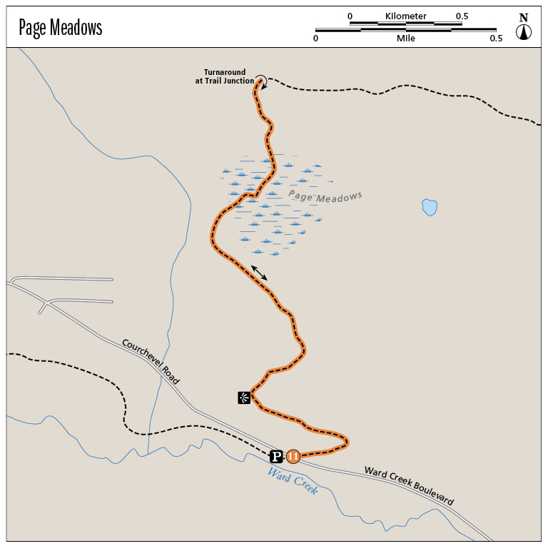
Miles and Directions
0.0Start on the north side of Ward Creek, where signs mark the TRT and describe camping regulations.
0.1At the signed junction with a steep dirt roadway, go left (west) and uphill through the woods.
0.5The climb mellows at a bend in the road with views west to the head of Ward Valley.
0.7Climb to a junction marked with an OHV sign. Trail markers for the TRT are about 25 yards ahead, as well as a sign for Page Meadows. Stay left (southwest) on the marked route, crossing two streamlets that may be dry in late season. The route narrows to singletrack.
1.1Reach another trail junction and stay right (northwest) on the signed TRT, passing low posts that prevent motor vehicle access.
1.2Arrive at the first (main) meadow.
1.5Pass through a narrow band of trees to a second, smaller meadow.
1.65Reach the trail junction with a sign noting distances to Ward Creek Road and Tahoe City. Turn around here and retrace your steps.
3.3Arrive back at the trailhead.
Hike Information
Local information: Information about businesses, restaurants, and activities in north Lake Tahoe, including Tahoe City, Kings Beach, Brockway, Homewood, and other North and West Shore towns, can be found at www.gotahoenorth.com. The phone number for the clearinghouse is (888) 434-1262. The Tahoe City Visitors Information Center is at 380 North Lake Blvd., Tahoe City, CA 96145; (530) 581-6900.
Restaurants: Gar Woods, 5000 North Lake Blvd., Carnelian Bay, CA 96140; (530) 546-3366; (775) 833-1234; (800) BY-TAHOE (298-2463); www.garwoods.com/index.html. Ah, the Wet Woody. A classic wooden-hulled boat skimming the blue surface of Lake Tahoe or . . . a rum drink that is a party in a glass. You’ll find both at Gar Woods, along with a menu of appetizers and entrees that perfectly complement a day on the trail.
Camping: Ed Z’berg Sugar Pine Point State Park offers camping during the summer months. The park’s 123 sites are equipped with metal bear boxes, where all food should be stored. Some sites are suitable for RVs, but they cannot exceed 32 feet in length. Campers have access to all park facilities. A fee is charged. For more information call (530) 525-7982 in the summer; (530) 525-3345 year-round. You can make online reservations through the Sugar Pine Point State Park website at www.parks.ca.gov; the link will take you to the park’s ReserveAmerica (www.reserveamerica.com) page.
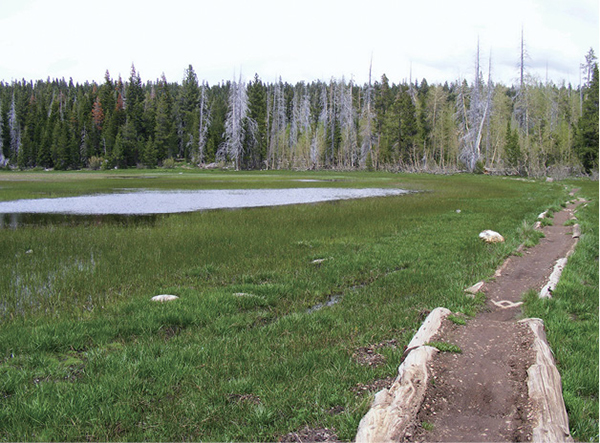
Raised walkways help protect the fragile wildflowers that thrive in Page Meadows.
Green Tip:
Consider citronella as an effective natural mosquito repellent.