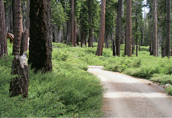
A verdant undergrowth thrives below the pines along General Creek.
12
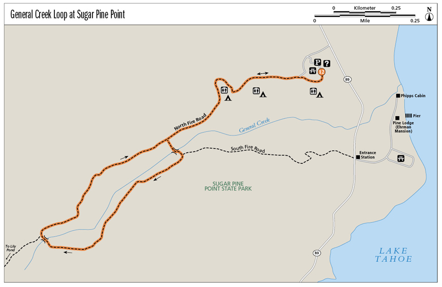
General Creek Loop at Sugar Pine Point
Walk in the footsteps (or ski tracks) of Olympic biathletes as you follow peaceful General Creek into Sugar Pine Point State Park’s wooded backcountry.
Start: At the day-use trailhead in the campground amphitheater parking lot
Distance: 4.7-mile lollipop
Hiking time: 3 hours
Difficulty: Moderate
Trail surface: Dirt forest roads; paved road
Best seasons: Spring, summer, fall
Other trail users: Mountain bikers, trail runners
Trailhead amenities: Parking at the trailhead. Restrooms, information, and water are available in the campground.
Canine compatibility: Leashed dogs permitted
Fees and permits: A day-use fee is charged.
Schedule: The Sugar Pine Point State Park trail system is open year-round from sunrise to sunset daily. Entrance station hours vary; in summer it is open from about 8 a.m. until 8 p.m.
Maps: USGS Homewood CA and Meeks Bay CA; map in the Sugar Pine Point State Park brochure available at the campground entrance station and online
Trail contact: Ed Z’berg Sugar Pine Point State Park, PO Box 266, Tahoma, CA 96142-0266; (530) 525-7982; www.parks.ca.gov
Finding the trailhead: From the Y junction of US 50 and CA 89 in South Lake Tahoe, follow CA 89 north for 17.5 miles to the signed entrance for Sugar Pine Point State Park. From the Y junction of CA 89 and CA 28 in Tahoe City, follow CA 89 south for 9.2 miles to the campground entrance on the right (west). Go left (south), behind the entrance station, to parking for the campground amphitheater. This is the day-use trailhead; the trailhead can also be accessed from the campground. GPS: N39 03.38' / W120 07.287'
The Hike
The biathlon has to be one of the most challenging—and bizarre—sporting events ever conceived. Cross-country skiing (an exhausting sport even when you are not racing) is paired with marksmanship; top speed on skis and greatest accuracy with a rifle determine the winner.
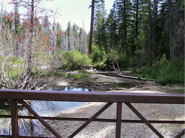
The General Creek Loop follows part of the route biathletes used in the 1960 Squaw Valley Olympic Games, offering hikers a chance to gain a new appreciation (or sense of astonishment) for the sport. Interpretive signs near the trailhead describe the Nordic trail system established for the games. But the sign near the second bridge crossing General Creek, more than 2 miles into the woods, is a real eye-opener. The pictures say it all: Skiers sprawled belly-down in the snow with the rifles they’ve carried on their backs aimed at targets across the white meadow. Stand where they lay and imagine . . .
The hike begins with a tour of the Sugar Pine Point campground. The most direct route to the trailhead proper is to follow the main campground road to the westernmost campground loop; the signed trail begins between campsites 76 and 125. Other trails, including a nature trail, are shown on the campground map. Some loop through the woods and eventually intersect the trail up General Creek.
A verdant undergrowth thrives below the pines along General Creek.
The dirt road that serves as the General Creek trail leads away from the campground through an open woodland. Pass a side trail that breaks left (south) back into the campground, following the roadway to the start of the loop. At the junction, go left (south) to the first General Creek crossing. A bridge spans the waterway; on the south side go right (west) on the gently climbing track.
Follow the creek westward for a meditative mile through the quiet forest, passing a burned area where the undergrowth has come back thick and lush. Bend north past the biathlon sign (“a contest of contrast”) to the second General Creek crossing. On the north side of the bridge, the singletrack Lily Pond Trail heads left (west). Stay right on the broad General Creek Loop, which follows the north side of the creek back toward the campground. The route again passes through an old burn, where wildflowers, thimbleberries, and ferns flourish in spring and early summer.
Pass an unmarked junction with a dirt road on the descent to the end of the loop portion of the lollipop, staying right (east). The route drops to the junction near the creek crossing; from this point retrace your steps to the campground trailhead, then through the camp to the day-use parking lot and trail’s end.
Sugar pines, among the most massive of the pines, produce the enormous cones that litter the woodland floor. The cones can be more than a foot long.
Miles and Directions
0.0Start in the amphitheater parking lot, passing behind the closed gate on the paved roadway. Ski trail and nature trail signs mark a convergence of paved paths. Stay right on the paved trail to the main camp road, then go left (west) on the camp road.
0.9Arrive at the signed General Creek trailhead, between campsites 76 and 125. Head down the wide graded dirt road into the woods.
1.0Pass a trail that leads left (south) into the campground. Stay straight on the main trail.
1.4At the trail junction (the start of the loop) go left (south). Cross the bridge over the creek. At the trail intersection on the south bank, turn right (west).
2.4Pass the biathlon sign and cross the creek via the bridge. The Lily Pond Trail heads left (west) on the north side of the bridge; stay right (east) on the General Creek trail.
3.1At the unsigned junction with a dirt road, stay right (east).
3.4Close the loop. Retrace your steps to the campground trailhead.
4.7Arrive back at the amphitheater parking area.
Hike Information
Local information: Information about businesses, restaurants, and activities in north Lake Tahoe, including Tahoe City, Kings Beach, Brockway, Homewood, and other North and West Shore towns, can be found at www.gotahoenorth.com. The phone number for the clearinghouse is (888) 434-1262. The Tahoe City Visitors Information Center is at 380 North Lake Blvd., Tahoe City, CA 96145; (530) 581-6900.
For the scoop on lodging, restaurants, and activities in South Lake Tahoe, look to the Lake Tahoe South Shore Chamber of Commerce. The chamber is located at 169 US 50, 3rd Floor, Stateline, NV 89449; call (775) 588-1728; visit www.tahoechamber.org.
Local events/attractions: Cross-country skiing is popular at the park in winter, with about 20 miles of groomed trails winding through Sugar Pine Point Park’s backcountry. Contact the park for more information by calling (530) 525-7982. A map is available at www.parks.ca.gov/pages/510/files/EdZSugarPinePtSkiTrailMapWinter2011.pdf.
Restaurants: Jake’s on the Lake, 780 North Lake Blvd., Tahoe City, CA 96145; (530) 583-0188; www.jakestahoe.com. This lakeside restaurant and bar features delicious fresh entrees and appetizers, including ahi tuna poke rolls and excellent burgers.
Camping: Ed Z’berg Sugar Pine Point State Park offers camping during the summer months. The park’s 123 sites are equipped with metal bear boxes, where all food should be stored. Some sites are suitable for RVs, but they cannot exceed 32 feet in length. Campers have access to all park facilities. A fee is charged. For more information call (530) 525-7982 in the summer; (530) 525-3345 year-round. You can make online reservations through the Sugar Pine Point State Park website at www.parks.ca.gov; the link will take you to the park’s ReserveAmerica (www.reserveamerica.com) page.
General Creek was the site of the Olympic biathlon in 1960.