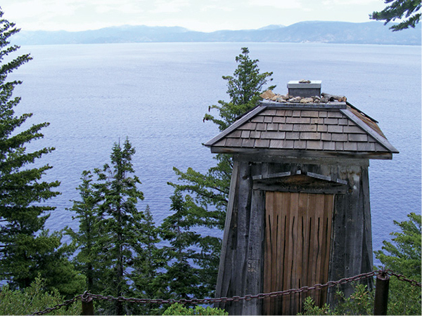
The lighthouse on Rubicon Point no longer guides boats on the lake, but it makes a fine destination for a hike.
13
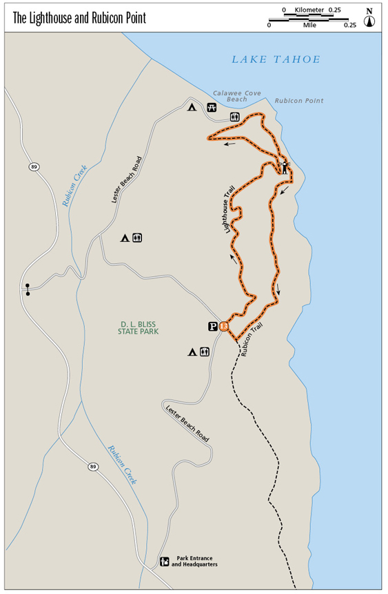
The Lighthouse and Rubicon Point
The historic lighthouse on Rubicon Point is at the high point of this loop, which also encompasses panoramic views of Lake Tahoe and a stretch of trail that skims a rocky cliff above the lake.
Start: At the trailhead parking area located about 1 mile down the park road
Distance: 2.5-mile loop
Hiking time: 2 hours
Difficulty: Moderate
Trail surface: Singletrack; rock staircases
Best seasons: Late spring, summer, fall
Other trail users: None
Trailhead amenities: Parking at the trailhead proper. Restrooms, information, and picnic facilities are available elsewhere in the park.
Canine compatibility: Leashed dogs permitted in the park; no dogs permitted on the trails
Fees and permits: A day-use fee is charged.
Schedule: The trail may be hiked from sunrise to sunset daily; visitor center hours are from 10 a.m. to 4 p.m. daily.
Maps: USGS Emerald Bay CA; map provided in the D. L. Bliss State Park brochure
Trail contact: D. L. Bliss State Park, PO Box 266, Tahoma, CA 96142; (530) 525-7277; www.parks.ca.gov
Finding the trailhead: From the intersection of US 50 and CA 89 in South Lake Tahoe, head north on CA 89 for 12.5 miles to the signed turnoff for D. L. Bliss State Park on the right (east). From Tahoe City, take CA 89 south for 15.8 miles to the park entrance. Follow the park road 1 mile east to the trailhead, which is on the left (west) side of the road. A limited number of visitors are admitted into the park; if you arrive after 10 a.m., check at the visitor center for availability. GPS: N39 59.353' / W120 05.915'
The Hike
The lighthouse that once warned sailors of submerged dangers off Rubicon Point is small and unassuming. It most resembles, of all the unfortunate possibilities, a wooden outhouse. But in the early days of the twentieth century, the humble structure housed a brilliant acetylene light that was integral to navigation on the lake. The light no longer guides boaters, but the structure, rebuilt in 2001, is a highlight along this loop through D. L. Bliss State Park.
The lighthouse isn’t the only example of innovative high country construction along the trail. Climbing away from Calawee Cove, the path tightropes across the face of a steep cliff high above the lake. Views from this aerie are superlative and the exposure is thrilling. A word of caution: Though protected by a railing, this stretch is not for those afraid of heights, and children should be watched carefully.
The Lighthouse Trail begins by climbing through a fire-scarred woodland. It flattens atop a ridge amid evergreens and boulders, then drops through more hauntingly beautiful burned forest. Drop to a trail junction with great views. The granite staircase leading to the lighthouse is to the left and descends steeply to the small wooden structure, which is perched on a rocky shelf overlooking the lake.
The lighthouse on Rubicon Point no longer guides boats on the lake, but it makes a fine destination for a hike.
Climb back to the trail crossing and go right (north) on the Lighthouse Trail, which follows long, shaded switchbacks down to the paved parking area at Calawee Cove. The cove’s little beach, though crowded in summer, is a nice place for a break or lunch. The signed junction with the Rubicon Trail is in the parking lot. Pick up that footpath and head up and south around Rubicon Point.
The trail is spectacularly exposed for a stretch, with a rail guarding against the abrupt drop, boardwalks spanning clefts, and head-thumping overhangs looming over the walkway. It’s so invigorating you might forget you are climbing . . . until you reach the granite staircase heading up and past a side trail to the lighthouse. Stay left (south) on the Rubicon Trail, enjoying heavenly views as the trail flattens.
As you near the end of the loop, the trail curves away from the lake into dense forest. At the signed trail junction in a clearing, take the side trail to the right (northwest); the left-hand trail, the Rubicon, leads south to Emerald Bay and Vikingsholm. The dark, needle-carpeted path leads to the park road and the Lighthouse trailhead.
If you have a chance to boat on the lake, head over to the base of the cliffs at Rubicon Point. You’ll find an impressive 30-foot rock below the lighthouse with a rope slung down its backside. If you are a thrill-seeker, you can use the rope to climb to the top and jump off. Or you can do what the sane people do, enjoying the daredevil show from the comfort of your vessel.
Miles and Directions
0.0Start at the signed Lighthouse trailhead, crossing a small bridge and climbing into a burned woodland.
0.75Drop to a trail intersection. Go left (north) for about 10 feet to an interpretive sign and the top of the stone staircase leading down to the lighthouse.
0.8Arrive at the lighthouse. Check it out, then climb back to the Lighthouse Trail and turn right (north).
1.4Descend to the parking lot and restrooms at Calawee Cove. Pick up the signed Rubicon Trail and head right (south).
1.6Reach the exposed part of the trail, with the wire rail, boardwalk, rock faces, and great views.
1.8Climb the granite staircase up to and past the trail to the lighthouse, staying left (south) on the Rubicon Trail.
2.1Pass a trailside overlook.
2.4Reach the clearing and trail junction. Go right (west) to the park road and trailhead.
2.5Arrive back at the trailhead.
Hike Information
Local information: Information about businesses, restaurants, and activities in north Lake Tahoe, including Tahoe City, Kings Beach, Brockway, Homewood, and other North and West Shore towns, can be found at www.gotahoenorth.com. The phone number for the clearinghouse is (888) 434-1262. The Tahoe City Visitors Information Center is at 380 North Lake Blvd., Tahoe City, CA 96145; (530) 581-6900.
For the scoop on lodging, restaurants, and activities in South Lake Tahoe, look to the Lake Tahoe South Shore Chamber of Commerce. The chamber is located at 169 US 50, 3rd Floor, Stateline, NV 89449; call (775) 588-1728; visit www.tahoechamber.org.
Camping: D. L. Bliss State Park offers camping during the summer months (the park is closed in winter). There are 138 sites, all equipped with metal bear boxes, where all food should be stored. Some sites are suitable for RVs, but they cannot exceed 18 feet in length. Campers are free to use all park facilities. A fee is charged. For more information call (530) 525-7277 or (530) 525-3345 (in summer). Online reservations can be made by visiting the D. L. Bliss State Park page at www.parks.ca.gov; the link will take you to the park’s ReserveAmerica (www.reserveamerica.com) page.