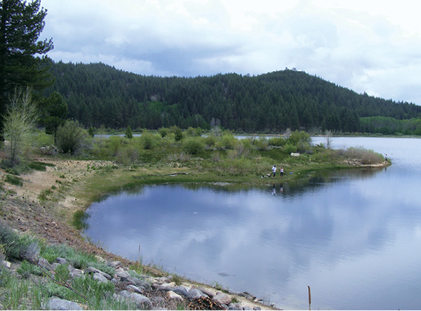
Anglers use the beaches and trails along Spooner Lake to find just the right place to cast a line.
15
Spooner Lake Loop
This splendid day hike circumnavigates the forested shoreline of Spooner Lake, once a water source for miners working the Comstock Lode near Virginia City.
Start: At the signed trailhead in the picnic area at Lake Tahoe–Nevada State Park
Distance: 2.1-mile loop
Hiking time: 1–2 hours
Difficulty: Easy
Trail surface: Singletrack; dirt roadway; pavement
Best seasons: Late spring, summer, and fall (when the aspens turn)
Other trail users: None on the loop itself; cyclists on the portions leading to and from the loop
Trailhead amenities: Restrooms, picnic sites, informational billboards, trashcans, a bike shop
Canine compatibility: Leashed dogs permitted
Fees and permits: A day-use fee is levied.
Schedule: The park is open 24 hours per day, 7 days a week, year-round to accommodate backcountry users. The entrance station is open from 8 a.m. to 9 p.m. from Memorial Day to Labor Day. From May 1 to Memorial Day, and from Labor Day to Sept 30, hours are from 8 a.m. to 7 p.m. From Oct 1 to Apr 30, hours are from 8 a.m. to 5 p.m.
Maps: USGS Glenbrook NV; state park map available at the entrance station; information signboard map at the trailhead
Trail contact: Lake Tahoe–Nevada State Park, PO Box 6116, Incline Village, NV 89452; (775) 831-0494; parks.nv.gov/parks/marlette-hobart-backcountry
Finding the trailhead: From the junction of NV 28 and Village Boulevard in Incline Village, follow NV 28 south for about 11 miles to the signed turnoff into Lake Tahoe–Nevada State Park. Turn left (east) into the park and follow the park road to the trailhead. From South Lake Tahoe/Stateline, follow US 50 north for about 12 miles to the junction with NV 28. Go left (west) onto NV 28 for 0.5 mile to the park entrance on the right. GPS: N39 06.369' / W119 54.963'
The Hike
Glades of quaking aspen, bright green in spring and vivid gold in fall, crowd the first mile of this flat, easy circuit around Spooner Lake. The aspen groves, including some gnarly old specimens with trunks scarred by graffiti, blend into the otherwise evergreen woodland on the lake’s shoreline. Wildflowers bloom among meadow grasses in small clearings, and breaks in the trees open to views across the water. Ducks and other waterfowl may be seen swimming along the shoreline, and if you are lucky you may spot an osprey.
The large information sign at the trailhead shows the extensive trail system that explores the Marlette-Hobart backcountry, anchored by Marlette Lake and Hobart Reservoir. Spooner Lake offers a kindler, gentler sampling of what you find farther in.
The other backcountry reservoirs, like Spooner Lake, were integral to the development of the Comstock Lode and the exploitation of the landscape and forests surrounding Lake Tahoe that resulted from the mining enterprise. Interpretive signs along the route detail Spooner Lake’s role in the complex delivery system that moved resources from the Sierra to the silver mines near Virginia City. An array of railroads, haul roads, and flumes (one 17 miles long) originated around the lake; these carried water and timber to the mines. Spooner Lake, then part of Spooner Ranch, was strategically located near a relatively low pass in the Carson Range. Ranch owner Michel Spooner, along with a partner, established Spooner Station in 1860, with a mill, hotel, saloon, and other accommodations serving the miners, lumberjacks, and travelers that crossed the pass.
Anglers use the beaches and trails along Spooner Lake to find just the right place to cast a line.
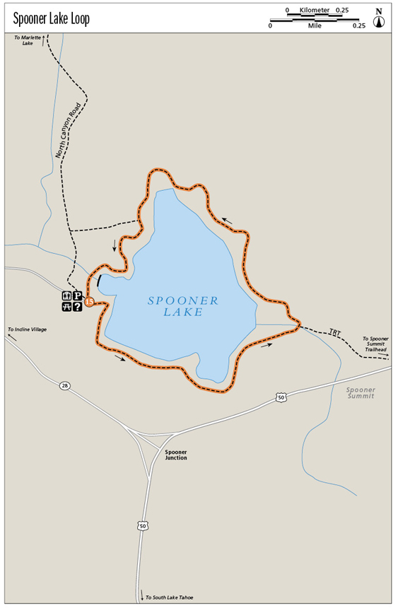
From the trailhead follow the signed paved path (North Canyon Road; lined with interpretive signs) down to the signed Spooner Lake trail at the base of the hill. The loop begins on the lakeshore and is described in a counterclockwise direction; turn right onto the path.
Montane ecotones—meadow, aspen forest, evergreen forest—merge seamlessly as you follow the well-maintained singletrack around the lake. Highway noise from US 50 can be a distraction at the outset, but it fades as you reach the woods on the northern shoreline, and trees screen the highway from view.
Near the halfway point you’ll reach the junction with the Tahoe Rim Trail (TRT); the route follows a portion of the long-distance trail back to the lake’s earthen dam. Anglers become more common as you approach the dam, with rocky beaches suitable for fishing and picnicking surrounding the sloping structure. The bugs can be brutal in season in marshy areas around the dam; walk with your mouth closed!
The loop closes on the far side of the dam. From the signed junction with North Canyon Road (which leads to Marlette Lake and other destinations in the backcountry), climb up through the woods and back to the picnic area, parking lot, and trailhead.
Miles and Directions
0.0Start at the trailhead next to the restrooms, signed for all trails. Follow the paved path past the large information sign, descending on the North Canyon Road to the lakeside. Turn right onto the signed Spooner Lake trail. Alternatively, you can go right from the paved path at the top of the hill, walking through the split-rail fence. Stay left (northeast) to a picnic area surrounded by boulders, and follow the dirt path down to a gravel road. Turn right (south); in 25 yards you will meet the signed Spooner Lake Loop.
0.6Pass through a meadow on boardwalks. At the junction stay left (straight) on the Spooner Lake Loop; an access trail breaks right toward US 50. The trail descends into quaking aspen groves.
1.0Cross a boardwalk over the inlet stream and climb to the junction with the Tahoe Rim Trail. Go left (southwest) on the signed TRT/Spooner Lake Loop.
1.6At the junction with the link to North Canyon Road and Marlette Lake, stay left (south), following the shoreline.
1.8Arrive at the dam and a trail junction. Cross the dam and go down through the spillway. Pass a signboard listing angling regulations, then cross the gravel road to the sign that points uphill to the parking area. Two paths lead through the woods; pick one and start the short climb.
2.1Arrive back at the trailhead.
Hike Information
Local information: Incline Village Crystal Bay Visitors Bureau provides information about lodging, recreation, and dining for the Nevada side of north Lake Tahoe. Contact the visitors bureau by calling (775) 832-1606 or (800) GoTahoe, or visit www.gotahoenorth.com. For information on lodging, restaurants, and activities in South Lake Tahoe, contact the Lake Tahoe South Shore Chamber of Commerce. The chamber is located at 169 US 50, 3rd Floor, Stateline, NV 89449; call (775) 588-1728; visit www.tahoechamber.org.
Services: Spooner Lake Outdoor Company operates the full-service Flume Trail Bike Shop in Incline Village, which offers shuttles for one-way travelers on the Marlette Flume Trail and the Tahoe Rim Trail. Call (775) 298-2501 or visit www.flumetrailtahoe.com.
Camping: The park maintains three primitive walk-in camps in the backcountry with a 14-day camping limit within a 30-day period. Contact the park at (775) 831-0494 for more information.
Green Tip:
Many people visit natural areas for quiet, peace, and solitude, so avoid making loud noises and intruding on others’ privacy.