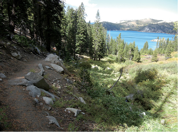
The last stretch of trail offers tantalizing views of the destination: Marlette Lake.
16
Marlette Lake
Take the trail to Marlette Lake when the aspens turn in the autumn. Gorgeous stands of the golden-leaved trees light up a good stretch at the start of this long, easy trek, begging for pictures and enticing hikers to linger. Marlette Lake, as blue as Tahoe, sits in a wooded bowl that is a delight at any time of year.
Start: At the trailhead in Lake Tahoe–Nevada State Park
Distance: 10-mile lollipop loop
Hiking time: 5–7 hours
Difficulty: Moderate
Trail surface: Singletrack; gravel service road
Best seasons: Late spring, summer, fall
Other trail users: Mountain bikers, trail runners
Trailhead amenities: Restrooms, picnic sites, informational billboards, trashcans, a bike shop where you can get trail information
Canine compatibility: Dogs not permitted
Fees and permits: A fee to enter Lake Tahoe–Nevada State Park
Schedule: The park is open 24 hours per day, 7 days a week, year-round to accommodate backcountry users. The entrance station is open from 8 a.m. to 9 p.m. from Memorial Day to Labor Day. From May 1 to Memorial Day, and from Labor Day to Sept 30, hours are from 8 a.m. to 7 p.m. From Oct 1 to Apr 30, hours are from 8 a.m. to 5 p.m.
Maps: USGS Glenbrook NV; state park map available at the entrance station; information signboard map at the trailhead
Trail contact: Lake Tahoe–Nevada State Park, PO Box 6116, Incline Village, NV 89452; (775) 831-0494; parks.nv.gov/parks/marlette-hobart-backcountry
Special considerations: North Canyon Road can be a busy place, particularly on weekends. While on the road be sure to stay right. Speed limits are posted but cyclists don’t always adhere, so it’s best to stay clear. Sharing the route is typically not a problem, as the track is plenty wide, but courtesy and an awareness of others is mandatory.
Finding the trailhead: From the junction of NV 28 and Village Boulevard in Incline Village, follow NV 28 south for about 11 miles to the signed turnoff into Lake Tahoe–Nevada State Park. Turn left (east) into the park and follow the park road to the trailhead. From South Lake Tahoe/Stateline, follow US 50 north for about 12 miles to the junction with NV 28. Go left (west) onto NV 28 for 0.5 mile to the park entrance on the right. GPS: N39 06.369' / W119 54.963'
The Hike
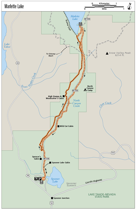
Marlette Lake is the most accessible destination in the backcountry of Lake Tahoe–Nevada State Park, a scenic target for hikers and mountain bikers on the Tahoe Rim Trail (TRT) and the Flume Trail (aka the Marlette Flume). Cyclists use North Canyon Road, a graded gravel service road, to reach the scenic lake from the trailhead near the park entrance, but there is a separate trail for hikers that skims the slopes above the road. This lollipop incorporates both trail and road, but you can minimize encounters with wheeled recreationalists by sticking to the trail both out and back.
The hike up to the lake, though steep in sections, is fairly straightforward. The lower reaches of the route are enlivened both by stands of aspen, firing gold in autumn, and by miners’ cabins, one in fairly good shape and the second a shambles. You will also pass the signed access trails for backcountry cabins that can be rented as bases for cross-country skiing.
The Marlette Lake Trail, for hikers and equestrians, departs from North Canyon Road after about 1 mile, and swings via easy switchbacks onto the east-facing hillside above the cycling track. Voices of wheeled travelers drift up into the woods, mingling with the screeches of jays and the wind in the treetops.
The last stretch of trail offers tantalizing views of the destination: Marlette Lake.
A steady but easy climb leads to a bridge that spans a year-round stream. A bench about halfway along offers a nice streamside respite near the remnants of a woodcutter’s cabin. Round a series of switchbacks until you are several hundred feet above the valley floor, with awesome views opening east onto the stony slopes of Snow Valley Peak.
Trails converge in the wooded saddle at the top of the climb. Follow a short unsigned path to the signed Marlette Lake Trail; the bike trail can be seen through the trees to the right, and Chimney Beach lies far down the trail on the left. A relatively steep descent leads across several bridges to the shoreline of Marlette Lake, where the trail ends on the service road near the spawning station.
You can retrace your steps to the trailhead from here, or complete the lollipop by following the service road (offering access to the Marlette Flume Trail) to the right. The lakeshore road leads to a staging area used by cyclists at the junction with North Canyon Road. A restroom is available here. Though unsigned, the return route is obvious, climbing steeply uphill, away from Marlette Lake and to the trail junction in the saddle above.
North Canyon Road drops steeply from the saddle at first, passing a link onto Snow Valley Peak and to the Tahoe Rim Trail (TRT) before the pitch eases on the valley floor. Pass the North Valley backcountry camp (with a restroom and link to the TRT) and the trail to the Wild Cat Cabin (used by cross-country skiers). Reach the junction with the lower end of the Marlette Lake Trail at the 9-mile mark and retrace your steps to the trailhead.
Timber for miners working the Comstock Lode was harvested from the slopes of the Carson Range year-round. High stumps, which can be spotted throughout the backcountry but are highlighted near the woodcutter’s cabin along the Marlette Lake Trail, indicate the snow depth at the time the trees were cut in winter.
Miles and Directions
0.0Start on the paved interpretive Beetle Discovery Trail, following the sign for all trails including the Spooner Lake Trail and the Marlette Flume Trail. Head down the dirt road; at its base the Spooner Lake Loop trail breaks right. Stay left on the signed North Canyon Road.
0.4Pass the access trail to the Spooner Lake Cabin. Stay left on the roadway.
0.8Pass Spencer’s Cabin.
1.0Reach the start of the signed Marlette Lake Trail and go left, leaving the roadway to the cyclists for now.
2.1Cross a bridge over a year-round stream.
2.75Pass a bench that perches above another stream, which is funneled under and through a jumble of granite boulders.
3.5Round switchbacks to views of Snow Valley Peak.
4.4Reach the signed trail junction at the top of the climb. Continue on an unsigned path to the signed Marlette Lake Trail. The bike route is to the right; a trail to Chimney Beach departs to the left. The Marlette Lake Trail drops down a narrow drainage spanned by a couple of bridges.
5.0Arrive at the service road on the shoreline of Marlette Lake. Turn right on the service road.
5.25Reach the staging area and restroom. Go right and uphill on the unsigned North Canyon Road.
6.0Back atop the saddle, pass the junction with the Marlette Lake Trail and continue downhill on North Canyon Road.
6.1Pass the junction with the Snow Valley Peak trail to the Tahoe Rim Trail, remaining on North Canyon Road.
7.0Pass North Canyon Camp (with a restroom and TRT trail link); stay on the obvious North Canyon Road.
8.1Pass an overgrown road leading to the creek; again, stay on the obvious main route.
8.3Pass the trail to Wild Cat Cabin, remaining right on the roadway.
9.0Reach the junction of North Canyon Road and the lower end of the Marlette Creek Trail. Retrace your steps from here.
10.0Arrive back at the trailhead.
Hike Information
Local information: Incline Village Crystal Bay Visitors Bureau provides information about lodging, recreation, and dining for the Nevada side of north Lake Tahoe. Contact the visitors bureau by calling (775) 832-1606 or (800) GoTahoe, or visit www.gotahoenorth.com. For information on lodging, restaurants, and activities in South Lake Tahoe, contact the Lake Tahoe South Shore Chamber of Commerce. The chamber is located at 169 US 50, 3rd Floor, Stateline, NV 89449; call (775) 588-1728; visit www.tahoechamber.org.
Services: Spooner Lake Outdoor Company offers shuttle service to one-way travelers on the Flume Trail. For more information call (775) 298-2501 or visit www.flumetrailtahoe.com.
Camping: The park maintains three primitive walk-in camps in the backcountry with a 14-day camping limit within a 30-day period. Contact the park at (775) 831-0494 for more information.