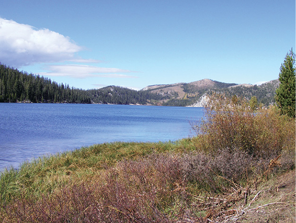
Marlette Lake is a scenic destination in the Marlette-Hobart backcountry on Lake Tahoe’s east shore.
Honorable Mentions
Sand Point Nature Trail
Take a break from the sun and water with a quick stroll along the boardwalk at Sand Point. With views across Lake Tahoe and into rocky coves along the shoreline, and interpretive signs describing some of the components that make the lake’s environment so beautiful and unique, the 0.4-mile wheelchair- and stroller-accessible loop is perfect for families. After you’ve made the round, you can settle on lovely Sand Point Beach for a picnic and a swim.
Sand Point Nature Trail is part of Lake Tahoe–Nevada State Park. The recreation area is open from 8 a.m. to 9 p.m. daily in summer. A day-use fee is levied. The area is extremely popular, with kayaking, diving, and picnic facilities as well as a visitor center and gift shop. The park also hosts the annual Lake Tahoe Shakespeare Festival in July and August; the amphitheater is cupped inside the trail loop.
If you’d like to extend your exploration of the East Shore near Sand Point, you can follow a 0.6-mile path to Memorial Point, where you’ll find more interpretive signage, restrooms, parking, and short paths that lead to overlooks.
To reach the trail from the junction of NV 28 and Village Boulevard in Incline Village, follow NV 28 south along Lake Tahoe’s east shore for 4.8 miles to the signed park entrance on the right (west). The parking lots fill by midmorning on summer days, restricting access to the park and trail. Parking, water, restrooms, and a visitor center and gift shop are near the trailhead.
Marlette Lake is a scenic destination in the Marlette-Hobart backcountry on Lake Tahoe’s east shore.
Tahoe Rim Trail at Spooner Summit
The Tahoe Rim Trail leads both north and south from Spooner Summit, with US 50 slipping between. Unless you plan to circumnavigate the lake, excursions both north and south are out-and-back affairs, leading as far into the backcountry as time, ability, and will allow.
Heading north from the summit, a hike of about 2 miles one way offers access to two overlooks with views of the Carson Valley, a panorama sublime in dusky and sienna hues. The contrast between the Tahoe basin and the high desert valley is striking. On one side of the divide lies the largest expanse of water in the Sierra Nevada; the landscape on the other side rolls high and dry for a thousand miles to the Rocky Mountains. You can turn around at either overlook, or continue on to Snow Valley Peak (about 5.5 miles one way from the trailhead) and beyond.
Heading south from the summit, the Tahoe Rim Trail climbs steeply via a series of switchbacks, then traverses a rolling ridgeline that offers expansive views of Lake Tahoe to the west and only fleeting views of the more austere Carson Valley to the east. The hiking mellows as you roller coaster along the ridgeline, with views of Mount Tallac and the Desolation Wilderness across the lake. The trail passes through sections of woodlands that have been harvested; scars from the clearing are healing, and the relatively open spaces present nice options for picnic spots or turnaround points. At about 2.5 miles logging roads collide with the trail below Duane Bliss Peak; this is also an ideal turnaround point. No trail leads up Bliss Peak, but intrepid hikers with good route-finding skills might take on the challenge. Hikers with more time and energy can continue along the TRT to Kingsbury Grade and beyond.
The TRT trailheads at Spooner Summit lie on either side of US 50 as it crests Spooner Summit. From Incline Village follow NV 28 south to its intersection with US 50. Turn left on US 50, and go 0.7 mile to Spooner Summit. For the trailhead leading south, go right into the picnic area parking lot; there is also parking along US 50. The trailhead for the northern section of the TRT is on the north side of the highway.
To reach the trailheads from the intersection of US 50 and CA 89 in South Lake Tahoe, drive north on US 50 to the US 50/NV 28 intersection at the base of Spooner Summit. Follow US 50 an additional 0.7 mile to the summit and trailheads.