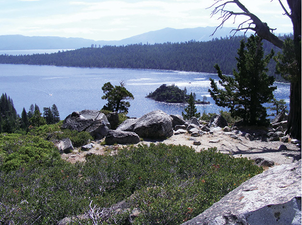
Seen from the top of the trail leading down to Vikingsholm, Fannette Island, the only island in Lake Tahoe, anchors the center of Emerald Bay.
17
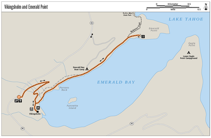
Vikingsholm and Emerald Point
Ocean-green and opalescent, it’s quite obvious how Emerald Bay, a gleaming fjord on Lake Tahoe’s south shore, earned its name. As if the natural beauty weren’t enough, spectacular Vikingsholm, huddled in the pines at the head of the bay, is another draw. Not so obvious is the jewel of a trail that leads along the bay’s north shore to its narrow mouth.
Start: At the signed trailhead in the large paved parking area on CA 89
Distance: 5.2 miles out and back
Hiking time: 3–4 hours
Difficulty: Moderate due to trail length and the steep ingress and egress
Trail surface: Graded dirt road; pavement, singletrack
Best seasons: Spring, summer, fall
Other trail users: None
Trailhead amenities: Parking, a gift and information station in the trailhead lot; restrooms, a visitor center, and picnic facilities at Vikingsholm. The parking lots at the Vikingsholm and neighboring Eagle Falls and Bayview trailheads are congested during high season. Lots fill quickly, but additional parking is available along the roadway. Please be courteous and safe in selecting a parking space.
Canine compatibility: Leashed dogs permitted in the park; no dogs allowed on trails or beaches or at Vikingsholm
Fees and permits: A parking fee is levied.
Schedule: The trail is open from sunrise to sunset. Vikingsholm and the Emerald Bay State Park visitor center are open daily from Memorial Day to Sept 30 from 10 a.m. to 4 p.m. Tours of Vikingsholm are available for a fee; call (530) 541-3030.
Maps: USGS Emerald Bay CA; Emerald Bay park map and brochure available online and at the visitor center
Trail contact: Emerald Bay State Park, PO Box 266, Tahoma, CA 96142; (530) 541-3030 (summer only); www.parks.ca.gov
Special considerations: You will gain and lose more than 400 feet in elevation within the first mile. Heed the trailhead sign that warns you not to attempt the route if you have heart, respiratory, or knee problems.
Finding the trailhead: From the intersection of US 50 and CA 89 in South Lake Tahoe, head north on CA 89 for 10.7 miles to the large Emerald Bay State Park parking area on the right (southeast). From Tahoe City, take CA 89 south for 17.6 miles (parking is on the left). The signed trail begins to the left of the huge rock slab that overlooks Emerald Bay. GPS: N38 57.261' / W120 06.619'
The Hike
Of all the shoreline estates along Lake Tahoe, Vikingsholm is arguably the most spectacular, with striking Scandinavian architecture and views opening onto one of Lake Tahoe’s most popular sights, sparkling Emerald Bay. Lora Josephine Knight built the home in 1929; it was designed by architect Lennart Palme, her nephew. The house, open for tours, features massive carved timbers, huge native granite boulders mortared into exterior walls, and a roof sewn with wildflowers. Mrs. Knight also rebuilt the structure atop Fannette Island (the only island in Lake Tahoe) as a teahouse. The island was also the home of Captain Dick Barter, “the Hermit of Emerald Bay,” in the late 1800s.
Hiking down to the storied estate is quintessential Tahoe and massively popular. But stretch a bit beyond the mansion’s grounds and you’ll find yourself on the Rubicon Trail, where chances are good that you’ll leave behind whatever crowds you met at Vikingsholm and enjoy Emerald Bay in relative solitude. In the off-season, whether spring or fall, if you walk quietly and watchfully as you near Emerald Point, you may see an eagle or osprey return to a lakeside nest, a tangle of twigs and branches perched at the top of a standing dead tree.
Seen from the top of the trail leading down to Vikingsholm, Fannette Island, the only island in Lake Tahoe, anchors the center of Emerald Bay.
Begin by heading down the wide path (a human highway in the busy summer season). Two switchbacks broken with long traverses drop to a junction where a park map points you downhill and right through open woodland to Vikingsholm. Take some time to explore the grounds, check out the visitor center, take a tour of the house, and picnic on the beach. When you’re ready to move on, pick up the signed Rubicon Trail on the northeast side of the main house (the right side as you face the building from the beach).
A series of bridges and boardwalks assist passage along the forested shoreline, which is pierced by drainages and lush with berries, ferns, and other verdant undergrowth. It’s easy going to Parsons Rock, which overlooks the bay and Fannette Island just before the trail enters the Emerald Bay Boat Camp.
The Rubicon merges with the camp road for a stretch, then breaks back to the shoreline as a dirt singletrack at a trail sign. The easy rambling continues, with short timber stair steps leading down to small half-moon beaches. The mouth of the bay, pinched by Emerald Point on the north and Eagle Point on the south, remains in sight until the Rubicon begins to bend north toward Rubicon Bay, D. L. Bliss State Park, and Calawee Cove. A clearing just before the trail turns north is the turnaround point (though any of the little beaches would work just as well). Return as you came, enjoying sporadic views up into the stony Desolation Wilderness as you go.
Emerald Bay State Park extends below the surface as an underwater shipwreck park. The underwater park, opened to divers in 1994, protects prehistoric artifacts such as bedrock mortars as well as six shipwrecks and other lost vessels, such as wooden cargo barges, a skiff, a rowboat, and a kayak.
Miles and Directions
Note: Mileages include a 0.3-mile tour of the paved paths around Vikingsholm.
0.0Start by descending the broad, well-graded trail.
1.0Arrive at Vikingsholm and tour the grounds.
1.3A signed trailhead for the Rubicon Trail is to the right (northeast) of Vikingsholm as you face it. Turn right (east) onto the flat path.
1.9Enter the boat camp and follow the paved road through the sites.
2.1At the east end of the camp, where the pavement begins to climb, the signed Rubicon Trail breaks to the right (east), turning to dirt and following the shoreline.
2.4Pass a series of short staircases that lead down to tiny beaches.
2.6Reach a clearing where trails appear to split, with the obvious Rubicon Trail breaking left (north). This is the turnaround point. The social tracks dead-end in the brush.
5.2Retrace your steps to the trailhead.
Option: The Rubicon Trail continues through neighboring D. L. Bliss State Park to Rubicon Point, a 4.5-mile one-way journey from Vikingsholm.
Hike Information
Local information: For the scoop on lodging, restaurants, and activities in South Lake Tahoe, look to the Lake Tahoe South Shore Chamber of Commerce. The chamber is located at 169 US 50, 3rd Floor, Stateline, NV 89449; call (775) 588-1728; visit www.tahoechamber.org. Or visit www.tahoesouth.com.
Local events/attractions: Guided tours of Vikingsholm, listed on the National Register of Historic Places, are available from Memorial Day through Sept. A fee is charged. Call the D. L. Bliss State Park office at (530) 525-9529 for more information.
Camping: D. L. Bliss State Park offers camping during the summer months (the park is closed in winter). There are 138 sites, all equipped with metal bear boxes, where all food should be stored. Some sites are suitable for RVs, but they cannot exceed 18 feet in length. Campers are free to use all park facilities. A fee is charged. For more information call (530) 525-7277 or (530) 525-3345 (in summer). Online reservations can be made by visiting the D. L. Bliss State Park page at www.parks.ca.gov; the link will take you to the park’s ReserveAmerica (www.reserveamerica.com) page.