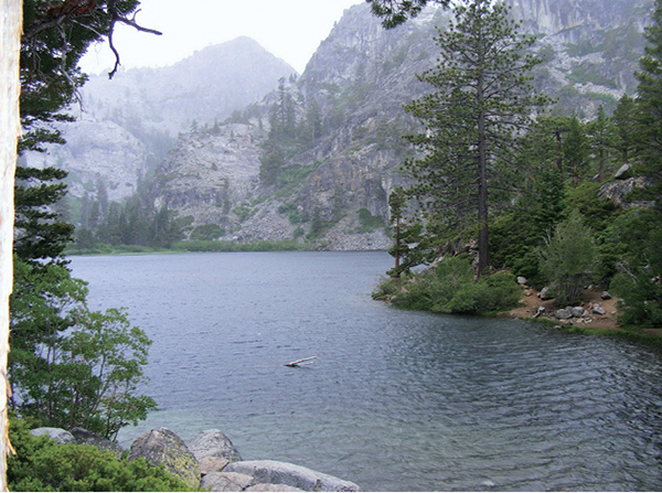
Storm clouds and mist drop onto Eagle Lake.
18
Eagle Lake
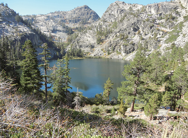
Dark and clear, Eagle Lake sits in a small basin bordered by steep granite aprons and great black-streaked cliffs. The classic Sierran setting and relative ease of access ensures this trail as one of the most popular around Lake Tahoe.
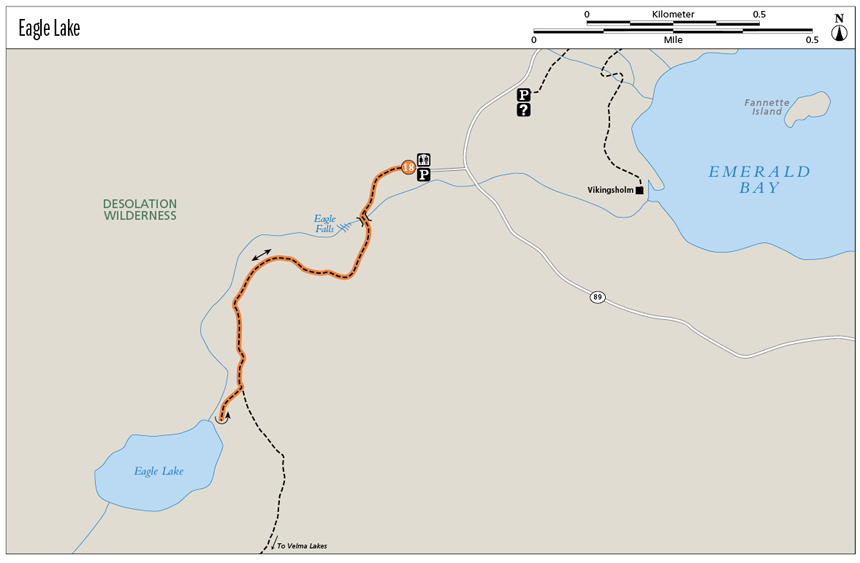
Start: At the well-signed trailhead in the Eagle Falls parking area off CA 89
Distance: 2 miles out and back
Hiking time: About 1 hour
Difficulty: Moderate due to some steep climbing
Trail surface: Dirt singletrack; granite stair steps
Best seasons: Summer and fall
Other trail users: None
Trailhead amenities: Parking, restrooms, picnic sites, trashcans, an information signboard, and wilderness permit site. The parking lots at Eagle Falls and neighboring Vikingsholm are congested during the high season. Additional parking is available along the highway. Please be courteous and safe in selecting a parking space.
Canine compatibility: Leashed dogs permitted. Because the trail is so popular, owners are asked to keep their pets under control and to clean up any messes.
Fees and permits: A vehicle parking fee is levied if you can find space in the trailhead lot. Parking along CA 89 is free. A free wilderness permit, available at the trailhead, is required.
Schedule: Sunrise to sunset daily
Maps: USGS Emerald Bay CA; a map on the signboard at the trailhead
Trail contact: US Forest Service Lake Tahoe Basin Management Unit, Forest Supervisor’s Office, 35 College Dr., South Lake Tahoe, CA 96150; (530) 543-2600; www.fs.fed.us/r5/ltbmu
Special considerations: You will gain and lose about 400 feet in elevation, and you must climb and descend a stretch over granite steps, so be prepared for a moderate workout.
Finding the trailhead: From the intersection of US 50 and CA 89 in South Lake Tahoe, head north on CA 89 for 10.3 miles to the signed Eagle Falls parking area on the left (south). From Tahoe City follow CA 89 south for 18 miles, past the parking area for Vikingsholm, to the Eagle Falls parking lot on the right. GPS: N38 57.118' / W120 06.811'
The Hike
The naked, glacier-slick walls of a stark Desolation Wilderness cirque form the backdrop for Eagle Lake. The trail leading up to the lake is varied and moderately challenging but quite short, making it well within reach of any hiker seeking an alpine experience without excess effort.
Begin on stairs at the trailhead sign, staying on the signed Eagle Lake Trail where it connects with the shorter Eagle Loop. The trail climbs gently at first, allowing you to enjoy views of cascades on Eagle Creek and the soaring pinnacles and great gray domes of the Desolation Wilderness.
Nearing the bridge over the cascades at Eagle Falls, a twisting stone stairway leads up, then down, to a vista point and the sturdy bridge spanning the cataract. Enjoy the falls, then cross the bridge and climb granite stairs and rocky singletrack past the wilderness boundary sign and to a large, smooth, flat granite slab dotted with pine and cedar. The trail is worn into the slab; rocks line the track as well, keeping all but the most distracted hikers on route.
Storm clouds and mist drop onto Eagle Lake.
The trail skirts a rock outcrop overlooking the wooded creek valley below, then traverses above the drainage on a well-worn wooded path, with the jagged crowns of the canyon walls rising above the forest canopy. Gentle climbing takes you to a trail junction at 0.9 mile; from here you can head deeper into the Desolation Wilderness. To reach Eagle Lake, however, bear right (west) toward the glacial cirque, following the arrow on the sign.
Scramble down to the shores of Eagle Lake at the 1-mile mark. A sprinkling of cedar, ponderosa, and Jeffrey pine provide shade from the vivid alpine sunshine. If you don’t mind icy water, Eagle Lake invites a dip. There is no beach, however, so you’ll have to dry off and/or enjoy the stunning views from a perch on a tree stump or a slab of sunbaked granite.
Return as you came, enjoying views of Emerald Bay and Lake Tahoe on the descent.
Miles and Directions
0.0Start by climbing steps to the junction of the Eagle Lake Trail and the Eagle Loop. Stay left (southwest) on the Eagle Lake Trail.
0.2Climb granite steps past the second Eagle Loop trail junction and stay left (south), crossing the bridge.
0.4Pass the Desolation Wilderness boundary.
0.9At the junction with the trail to the Velma Lakes, stay right (south) on the signed trail to Eagle Lake.
1.0Arrive at Eagle Lake.
2.0Retrace your steps to the trailhead.
Options: From the trail intersection just before Eagle Lake, you can head farther and higher into the Desolation Wilderness. The wilderness offers an abundance of backpacking possibilities, with Dicks Lake, Fontanillis Lake, and the Velma Lakes among the nearest destinations.
Hike Information
Local information: For the scoop on lodging, restaurants, and activities in South Lake Tahoe, look to the Lake Tahoe South Shore Chamber of Commerce. The chamber is located at 169 US 50, 3rd Floor, Stateline, NV 89449; call (775) 588-1728; visit www.tahoechamber.org. Or visit www.tahoesouth.com.
Local events/attractions: Guided tours of historic Vikingsholm, located across CA 28 from the Eagle Falls trailhead, are available from Memorial Day through Sept. A fee is charged. Call the D. L. Bliss State Park office at (530) 525-9529 for more information.
Camping: D. L. Bliss State Park offers camping during the summer months (the park is closed in winter). There are 138 sites, all equipped with metal bear boxes, where all food should be stored. Some sites are suitable for RVs, but they cannot exceed 18 feet in length. Campers are free to use all park facilities. A fee is charged. For more information call (530) 525-7277 or (530) 525-3345 (in summer). Online reservations can be made by visiting the D. L. Bliss State Park page at www.parks.ca.gov; the link will take you to the park’s ReserveAmerica (www.reserveamerica.com) page.
Eagle Lake is a popular destination in the Desolation Wilderness and is relatively easy to reach.