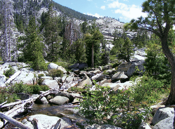
A series of cascades spills out of the Desolation Wilderness into Cascade Lake.
20
Cascade Falls
A brief walk through nicely spaced evergreens is a peaceful preamble to the rocky path and raucous creek at the end of the trail to Cascade Falls. Views of Cascade Lake and Lake Tahoe add to the hike’s appeal.
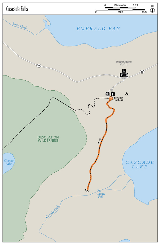
Start: At the signed trailhead at the day-use parking lot in the Bayview Campground
Distance: 2 miles out and back
Hiking time: 1–2 hours
Difficulty: Moderate due to climbs and descents over rocky terrain
Trail surface: Dirt singletrack; granite
Best seasons: Late spring, summer, fall
Other trail users: None
Trailhead amenities: Parking, restrooms, trashcans, water, and informational signboards are available in the Bayview Campground.
Canine compatibility: Leashed dogs permitted
Fees and permits: None
Schedule: Sunrise to sunset daily
Maps: USGS Emerald Bay CA
Trail contact: US Forest Service Lake Tahoe Basin Management Unit, Forest Supervisor’s Office, 35 College Dr., South Lake Tahoe, CA 96150; (530) 543-2600; www.fs.fed.us/r5/ltbmu
Finding the trailhead: From the intersection of US 50 and CA 89 in South Lake Tahoe, head north on CA 89 for 9.4 miles to a left (south) turn into the Bayview Campground. From Tahoe City follow CA 89 south for 18.9 miles, past the parking areas for Vikingsholm and Eagle Falls, to a right turn into the campground. Follow the campground road 0.3 mile to limited parking at the signed trailhead. Direct access to the trailhead may be difficult in high season; be prepared to park outside the campground or in safe pullouts along the highway. GPS: N38 56.607' / W120 06.000'
The Hike
Boisterous Cascade Creek feeds both Cascade Falls and Cascade Lake. The dark, still lake, cupped in a wooded bowl and surrounded by private property, is off-limits to hikers. The falls are off-limits too, rendered inaccessible by steep granite faces. But above the falls the creek is a friendly destination, coursing over smooth granite slabs. Settle in on the sunny rocks and enjoy the cooling mists while taking in vistas of Cascade Lake and Lake Tahoe.
To begin, walk behind the information kiosk and turn left (south) onto the signed Cascade Trail. The trail bends around two short trail posts, passing through a mixed evergreen forest, then climbs a short, stone stairway to an overlook of the falls in the distance, as well as Cascade Lake and Lake Tahoe.
A series of cascades spills out of the Desolation Wilderness into Cascade Lake.
At about the 0.5-mile mark, the trail begins a rocky downward traverse of the slope on the north side of Cascade Lake. Pick your way down to and then along the base of a granite cliff, taking care as the footing is uneven. You can catch glimpses of the falls tumbling toward the lake, but be sure to stop walking before you look.
Cross a relatively narrow ledge, then climb granite steps and broken rock to broad sun-splashed slabs that border the creek. A lovely granite bowl opens upstream, stretching back into Desolation Wilderness. A maze of trails has been worked onto the landscape over the years, some marked by “ducks” (stacks of rocks also known as cairns) and others delineated by lines of rocks. Look left and downhill for a wooden trail marker that points the way to the falls overlook. Stay low (left and north) to get closer to the falls, but don’t get too close as you don’t want to take a tumble. Stay high (right and south) to reach stretches of the creek that permit water play and toe-dipping.
The whole terrace opens on wonderful views across Lake Tahoe. Take in the sights, cool your jets, then return as you came.
Miles and Directions
0.0Start behind the informational signboard, turning left (south) at the sign pointing toward cascade falls.
0.5Head up the stone steps to lake views and vistas of the falls.
0.7Traverse across slabs and steps at the base of a granite wall.
0.8The trail levels as you approach the creek, and the granite terrace opens uphill to the south.
1.0Reach the creek above the falls. Enjoy the sun and views, then return as you came.
2.0Arrive back at the trailhead.
Option: A right (southwest) turn at the Bayview trailhead puts you on the trail to Granite Lake and other destinations in the Desolation Wilderness, including the Velma Lakes. A wilderness permit for day use is required and available at the trailhead.
Hike Information
Local information: For the scoop on lodging, restaurants, and activities in South Lake Tahoe, look to the Lake Tahoe South Shore Chamber of Commerce. The chamber is located at 169 US 50, 3rd Floor, Stateline, NV 89449; call (775) 588-1728; visit www.tahoechamber.org. Or visit www.tahoesouth.com.
Camping: Thirteen campsites are available on a first-come, first-served basis at the Bayview Campground. Recreational vehicles are limited to 20 feet in length. A fee is charged. For more information contact the forest service’s Lake Tahoe Basin Management Unit by calling (530) 543-2600, or visit www.fs.fed.us/r5/ltbmu.