24
Angora Lakes
Pack your towels and bring the kids: The Angora Lakes Trail is short, sweet, and the perfect introduction to hiking in the mountains around Lake Tahoe.
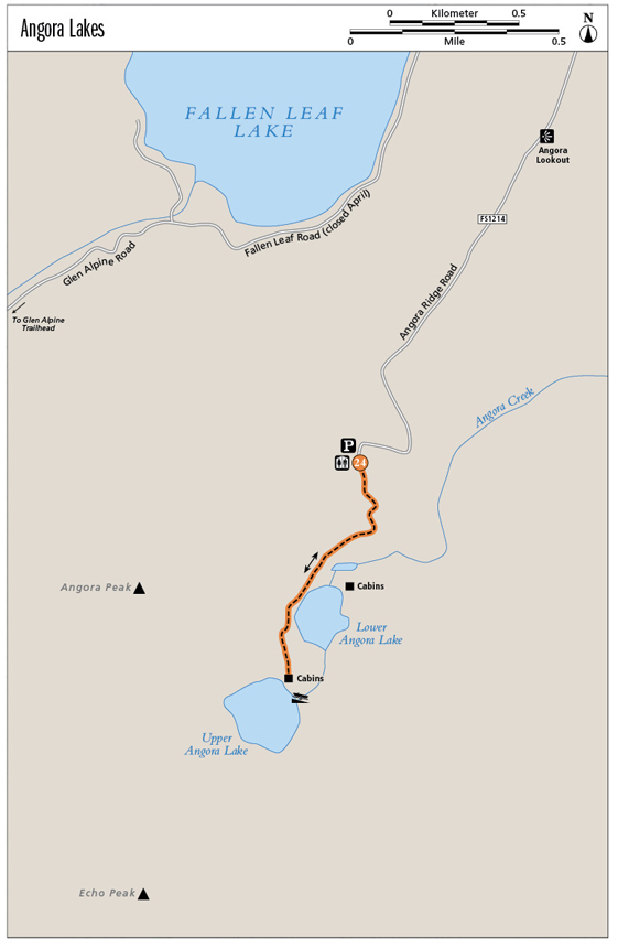
Start: At the gate in the upper parking lot at the end of Forest Road 1214
Distance: 1 mile out and back
Hiking time: 45 minutes to 1 hour
Difficulty: Easy
Trail surface: Dirt access road
Best seasons: Summer and fall
Other trail users: Mountain bikers and the occasional automobile
Trailhead amenities: Parking, restrooms, information, a fee station. Food, water, restrooms, and information are available at the Angora Lakes Resort at trail’s end.
Canine compatibility: Leashed dogs permitted; dogs may not swim in the lake
Fees and permits: A parking fee is levied.
Schedule: Sunrise to sunset daily. The resort is open daily from mid-June to mid-Sept.
Maps: USGS Echo Lakes CA; no map is needed
Trail contact: US Forest Service Lake Tahoe Basin Management Unit, Forest Supervisor’s Office, 35 College Dr., South Lake Tahoe, CA 96150; (530) 543-2600; www.fs.fed.us/r5/ltbmu
Finding the trailhead: From the intersection of US 50 and CA 89 in South Lake Tahoe, go north on CA 89 for 3 miles to Fallen Leaf Lake Road. Turn left (west) onto Fallen Leaf Lake Road and go 2 miles to Tahoe Mountain Road. Turn left (southwest) onto Tahoe Mountain Road and follow it for 0.4 mile to unsigned FR 1214 (look for an open gate; the road appears to be dirt at the outset). Turn right (west) onto FR 1214 and travel 3 miles on the scenic, narrow, paved roadway to the parking area. The trailhead is beyond the gate at the south end of the upper lot. GPS: N38 52.261' / W120 03.788'
The Hike
After a short hike up a wide access road (with just enough elevation gain to get your heart pumping), you’ll land on the sandy shores of Upper Angora Lake, replete with a spectacular alpine setting, cool water for swimming, rowboats for rent, and a snack bar that features some of the best lemonade money can buy. It’s definitely not a wilderness experience, but the hike has a ton of charm, and the destination, framed by steep granite walls and featuring a sunny slip of beach, is a dream.
The route is straightforward: Follow the Angora Lakes access road as it loops in broad arcing turns up a boulder-strewn, forested hillside. After the short climb, the path flattens and is intersected by social paths that lead to private residences on Lower Angora Lake. Stay on the main track, tracing the north shore of the lower lake.
A second, exceptionally brief climb leads to the snack bar and cabins on the eastern shores of Upper Angora Lake, part of the Angora Lakes Resort. The west and north shores are contained by black-streaked terraced cliffs that form the lower reaches of Echo and Angora Peaks. The beach hugs the north shore; stake out a patch of sand, sip some luscious fresh-squeezed lemonade, and enjoy.
Angora Lakes and Angora Peak got their names from the goats that prospector and Sierra Club partner Nathan Gilmore ran on the land. Their wool was exported to England.
Miles and Directions
0.0Start by heading up the broad, busy dirt track.
0.2Reach Lower Angora Lake.
0.5Rest on the shores of Upper Angora Lake. Swim, boat, and enjoy, then retrace your steps.
1.0Arrive back at the trailhead.
Hike Information
Local information: For information on lodging, restaurants, and activities in South Lake Tahoe, contact the Lake Tahoe South Shore Chamber of Commerce. The chamber is located at 169 US 50, 3rd Floor, Stateline, NV 89449; call (775) 588-1728; visit www.tahoechamber.org. Or visit www.tahoesouth.com.
Local events/attractions: Angora Lakes Resort offers day-use access to the snack shack (where the lemonade is sold), as well as kayak and boat rentals. Cabins book far in advance; visit www.angoralakesresort.com or call (530) 541-2092 for more information.
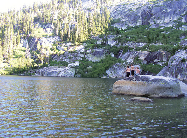
Three young hikers get ready to plunge into Upper Angora Lake.