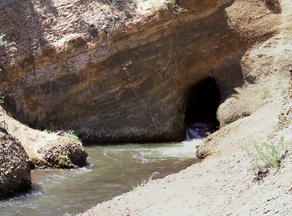
Water from the High Sierra spills from the Hole in the Wall.
33
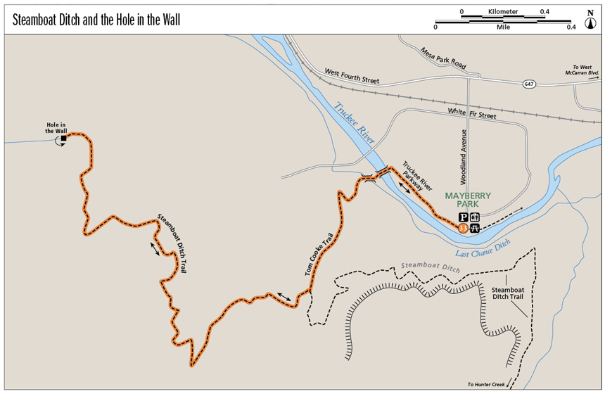
Steamboat Ditch and the Hole in the Wall
Reno’s Hole in the Wall is not an outlaw hideout. It’s literally a hole in a rock wall: a narrow tunnel gushing snowmelt into Steamboat Ditch. The trail to the hole begins alongside the cooling flow of the Truckee River, then climbs to a ditchside walk with great views.
Start: On the Truckee River Parkway in Mayberry Park
Distance: 5.6 miles out and back
Hiking time: 3–4 hours
Difficulty: Moderate
Trail surface: Paved bike path, dirt singletrack, dirt roadway
Best seasons: Winter, spring, and fall. Avoid the trail on hot days, as it is completely exposed to the desert sun.
Other trail users: Mountain bikers, equestrians, trail runners
Trailhead amenities: Though there are plenty of spaces in the paved lot at Mayberry Park, these fill quickly on warm spring and summer weekends. The park also has restrooms, trashcans, picnic greens, and easy river access.
Canine compatibility: Leashed dogs permitted (but be warned: many run free)
Fees and permits: None
Schedule: As a rule of thumb, Washoe County Parks are open from 8 a.m. to sunset. Formal hours are 8 a.m. to 9 p.m. from Memorial Day weekend to Labor Day weekend; 8 a.m. to 7 p.m. from Labor Day to the start of standard time; 8 a.m. to 5 p.m. from the start of standard time to the start of daylight savings time in spring; and 8 a.m. to 7 p.m. from the start of daylight savings time to Memorial Day weekend.
Maps: USGS Verdi NV, Mount Rose NW NV; www.nvtrailmaps.com
Trail contact: Mayberry Park is managed by the Washoe County Department of Regional Parks and Open Space, 2601 Plumas St., Reno, NV 89509; (775) 823-6500; www.washoecountyparks.com. Other trail segments are maintained by City of Reno Parks, Recreation & Community Services, City Hall, 1 E. First St., Eleventh Floor, Reno, NV 89501; (775) 334-2260; www.cityofreno.com. The US Forest Service also manages some of the land along the route, and the trail crosses parcels of private land as well.
Special considerations: The Steamboat Ditch Trail crosses some parcels of private property, so remain on the ditchside track. Social paths intersecting the Tom Cooke Trail should be avoided, as shortcutting causes erosion, degrades the environment, and creates unsightly scars on the landscape.
Other: Mayberry Park is often crowded in spring, summer, and fall. Parking can be difficult; a second lot is east of the main lot down the dirt road.
Finding the trailhead: From I-80 westbound from Reno, take the West McCarran Boulevard exit. Go left (south) on West McCarran for 0.7 mile to West Fourth Street. Turn right (west) on West Fourth Street and travel 1.9 miles to Woodland Avenue. Turn left (south) and follow Woodland Avenue for 0.4 mile to its end in a driveway between warehouses; the driveway leads into Mayberry Park and to the Truckee River Parkway. GPS: N39 30.171' / W119 53.700'
The Hike
Linking the Truckee River Parkway, the Tom Cooke Trail, and the Steamboat Ditch Trail, hikers are treated to a short tour of the Truckee’s thick riparian corridor, a long exploration of the high desert below the steep slopes of the Carson Range, and great views of Peavine Peak and the Truckee Meadows.
The path to the Hole in the Wall begins among the cottonwoods that shade the Truckee River in Mayberry Park, which on hot summer days is populated with picnicking families and young people carrying tubes and small rafts to take onto the river. Dirt tracks lead to narrow beaches along the Truckee, where rafters put in or spread picnic blankets.
Follow the paved Truckee River Parkway right (west) through the river’s bottomlands, with warehouses bordering on the right (north) and steep, undeveloped canyon walls on the left (south). The pavement ends behind the Patagonia warehouse at a metal bridge and a rustic picnic shelter. Crossing the bridge is a bit exciting (especially for kids and dogs); spaces between the planks that make up the floor of the span are separated just enough for you to look down onto the swift flow of the water below.
On the other side of the bridge, the trail climbs left (southwest) to a wooden footbridge spanning the Last Chance Ditch. Like the Steamboat Ditch, which cruises along the hillside above, the Last Chance carries Sierra snowmelt to thirsty high desert ranches. The signed Tom Cooke Trail begins on the south side of the ditch.
The well-built singletrack uses switchbacks to ascend a steep, rocky fold in the scrub-covered hillside. Practice good stewardship of the open space by avoiding the social routes carved by careless hikers and cyclists cutting switchbacks.
Water from the High Sierra spills from the Hole in the Wall.
The Tom Cooke Trail tops out on an open hillside with views up and across the grass- and sage-covered foothills of the Carson Range. Views north across the Truckee River valley are of sprawling Peavine Peak. Subdivisions and business parks fill the valley itself, and the whistle of a passing train (along with highway noise from the adjacent interstate) may waft up to the vista point.
The Tom Cooke Trail widens to doubletrack before it reaches its junction with the Steamboat Ditch Trail. At the T intersection with the ditch trail, go right (west) on the obvious, well-used dirt roadway. Heading left on the Steamboat Ditch Trail will take you east into the Hunter Creek drainage.
Sections of the Steamboat Ditch Trail are very popular with hikers, mountain bikers, and trail runners. The trail crosses private land but has been in public use a very long time. It’s likely you won’t see a fence or sign noting property boundaries or forbidding passage. Still, some land managers are uncomfortable with public use for obvious (and unfortunate) liability issues. Efforts are underway to formalize public access to the entire trail. Meanwhile, trail lovers continue to follow the ditch, enjoying a distinctive stripe of riparian greenery on the otherwise brown and scrubby mountainsides.
Traverse several gullies as you wind westward along the ditch. It’s a gentle, almost imperceptible climb to the Hole in the Wall, and the path winds in and out of creases in the topography, offering different views depending on the orientation. Sometimes you gaze down on the Truckee River Valley and Peavine, sometimes across the Truckee Meadows across Reno’s skyline and into distant blue-gray ranges of the Great Basin, sometimes up into the stony heights of the Carson Range. Occasionally, a diversion gate marks the head of one of the ravines.
You can’t help but note the lone pine tree along the track as you approach the Hole in the Wall. The trail slips through a cut in the yellow and brown hillside, then through a spindly bower of shade trees to where, in spring and early summer, water erupts with whitewater force into the ditch through the hole. Unsigned use trails continue into the hills from this point, but the flat open area near the small pool at the mouth of the tunnel makes a nice picnic spot and a logical turnaround point. To retrace your steps to the trailhead, just go with the flow.
The Steamboat Ditch, completed in the early 1880s, stretches for about 47 miles from the foothills near Verdi to the farms and ranches on the dry desert flatlands surrounding Reno. The Steamboat Ditch Company maintains the ditch. Whatever water is not used for irrigation funnels back into the Truckee again at the end of the ditch run.
Miles and Directions
0.0Start on the paved Truckee River Parkway heading right (west).
0.3Cross the bridge to the south side of the Truckee, then bear left (southwest) to cross the Last Chance Ditch and arrive at the signed start of the Tom Cooke Trail.
0.7Reach the top of the climb at a vista point.
0.9Arrive at the T junction with the Steamboat Ditch Trail. Go right (west) on the dirt road; the ditch trail also branches left (east) toward Reno.
1.4Curl through a gully with a ditch gate.
2.3Reach the junction with a dirt road leading right (north) away from the ditch. Stay left (southwest) on the obvious ditch trail. Less than 0.1 mile farther, cross a concrete diversion dam/gate in a gully.
2.5Pass a lone pine.
2.8Arrive at the Hole in the Wall and turnaround point.
5.6Arrive back at the Mayberry Park trailhead.
Hike Information
Local information: The Chamber, serving Reno, Sparks, and northern Nevada, offers information and links to community events, government, and businesses including restaurants and lodging. The Reno office is at 449 S. Virginia St. 2nd Floor, Reno, NV 89501; (775) 636-9550; www.thechambernv.org. For information about the city of Reno, call Reno Direct at (775) 334-INFO or visit www.reno.gov.

The flat trail alongside Steamboat Ditch offers views out into the Truckee Meadows.