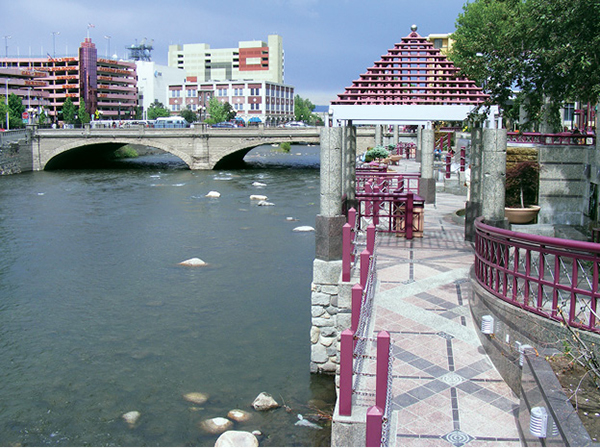
An urban trail follows the Truckee River through downtown Reno.
35
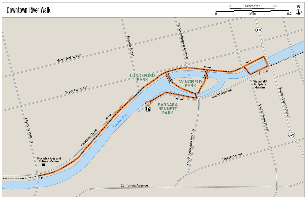
Downtown River Walk
The Truckee River flows right through the glitz of downtown Reno, and the town has dressed up the promenade along its banks with colorful landscaping, sculpture, artificial waterfalls, bridges, and a whitewater park.
Start: On the paved path in Barbara Bennett Park
Distance: 2 miles out and back (with optional extensions)
Hiking time: About 1 hour
Difficulty: Easy
Trail surface: Pavement
Best seasons: Year-round
Other trail users: Cyclists, trail runners, skaters
Trailhead amenities: Parking available in Barbara Bennett Park (space permitting), and along roadways bordering the trail. Bennett Park also has restrooms, informational signage, and offers access to the whitewater park.
Canine compatibility: Leashed dogs permitted
Fees and permits: None
Schedule: 24 hours a day, 7 days a week, year-round
Maps: USGS Reno NV; no map is necessary
Trail contact: City of Reno Parks, Recreation and Community Services Department, 190 E. Liberty St., Reno, NV 89501; (775) 334-6265; www.cityofreno.com
Finding the trailhead: From I-80 take the downtown Reno/Virginia Street exit. Head south on Virginia Street for about 0.5 mile, through downtown, to West Second Street. Go right (west) on Second Street for 2 blocks to North Arlington Avenue. Go left (south) on North Arlington, over the Truckee River, and turn right (west) into signed Barbara Bennett Park. Parking is available on city streets in this area, too. GPS: N39 31.434' / W119 49.019'
The Hike
Whether you’re a gambler working a blackjack table or a Reno resident working a casino shift, the Truckee River Parkway offers an escape from your labor. The paved trail, artfully built along the sparkling Truckee adjacent downtown Reno, provides a convenient and entertaining outdoor experience.
In addition to letting you stretch your legs and breathe fresh air, the riverside path overflows with people-watching potential. Cyclists, skaters, dog walkers, waders, rafters, kayakers, picnickers, dancers, basketball players, jugglers, and other street performers—they are all here, sharing the waterfront pathway with moms pushing strollers and couples holding hands. The kayakers are arguably the most fun to watch, spinning in whitewater created by artificial rock bars that pinch the river’s flow. The kids are fun to watch, too, jumping from the rocks into the water and floating gently downstream.
Getting clear of the crowds is as easy as melding with them. A few blocks west of downtown the trail enters a greenbelt in a quiet neighborhood, where painted benches overlook the river in the shade of spreading cottonwoods. Impressive homes perch on the high south-side embankment; more modest homes line the north side.
You can access this popular 13-mile long trail—and all its amenities—from a variety of points along its length, so feel free to improvise on the tour described here. The walk begins in busy Bennett Park on the south side of the river near the whitewater park. Head east (downstream) to Wingfield Park, an island reached by arcing pedestrian bridges. The park is outfitted with an amphitheater and grassy greens.
An urban trail follows the Truckee River through downtown Reno.
The trail continues down the north side of the river, offering access to shopping and restaurants as well as the casinos. Continue east (downstream), crossing the next bridge to the south side of the Truckee (alongside Island Avenue). Here you’ll enter the waterfall and sculpture garden, where colorful flowerpots and small gazebos mingle with sculptures of eagles, deer, bear, mountain goats, and other creatures being showered in sheets of water.
You can continue east on the parkway all the way to Reno’s sister city of Sparks, but to reach the greenbelt stretch, circle back to the west at Virginia Street, crossing again to the north side of the river and returning to Wingfield Park. Cross North Arlington Avenue, pausing on the bridge to check out the river antics, then continue west, past little Lundsford Park, into a quiet neighborhood.
The trail is lined with sturdy cottonwoods shading a linear green that borders the riparian zone along the riverbanks. The homes on the north side, along Riverside Drive, are charming, but the mansions on the south side are to be envied. Benches along the trail look across the river to the palatial houses and their lovely gardens.
Though the trail continues westward toward the Carson Range, a likely turnaround point is the Keystone Avenue Bridge, just beyond the McKinley Arts and Culture Center and interpretive signs about Reno’s origins and local arts and culture. Unless you choose to explore farther, retrace your steps to the trailhead.
The Truckee River Parkway is 13 miles long and can be picked up at a number of locations within Reno. Extend your walk east from the Reno whitewater park to the whitewater park in neighboring Sparks, or continue west through quiet neighborhoods toward the mountain front.
Miles and Directions
0.0Start at Bennett Park heading east. Cross the intersection of West First Street and North Arlington Avenue to Wingfield Park.
0.1Pass an interpretive sign about Reno’s origins, then cross the bridge to the south side of the river and explore the waterfall and sculpture garden.
0.4Circle back to Wingfield Park, cross North Arlington Avenue, and head left (west) on the north side of the river.
0.6Enter the neighborhoods bordering Riverside Drive.
0.8Reach the greenbelt section, with benches and views of riverside estates.
1.0Pass the McKinley Arts and Culture Center before the turnaround point under the Keystone Avenue Bridge. Retrace your steps toward Wingfield Park.
2.0Arrive back at the Bennett Park trailhead.
Hike Information
Local information: The Chamber, serving Reno, Sparks, and northern Nevada, offers information and links to community events, government, and businesses including restaurants and lodging. The Reno office is at 449 S. Virginia St. 2nd Floor, Reno, NV 89501; (775) 636-9550; www.thechambernv.org. For information about the city of Reno, call Reno Direct at (775) 334-INFO, or visit www.reno.gov/index.aspx?page=1.
Restaurants: Campo Restaurant, 50 N. Sierra St., Reno, NV 89501; (775) 737-9555; www.camporeno.com. Looking for a good old carbo load before or after a long day on the trail? Campo is the spot. Located in downtown Reno, the restaurant features a variety of pizzas and pastas, with a few other entree and lunch selections.
Organizations: The Truckee River Parkway is part of a larger entity, the Tahoe-Pyramid Bikeway, which will, when completed, link Lake Tahoe to Pyramid Lake. The bikeway vision cobbles together trails, roads, and bridges as it drops from the headwaters of the Truckee to its end. For more information visit the Tahoe-Pyramid Parkway website at www.tpbikeway.org or call (775) 825-9868.