In addition to hiking trails, Bartley Ranch Regional Park also has an interpretive center.
37
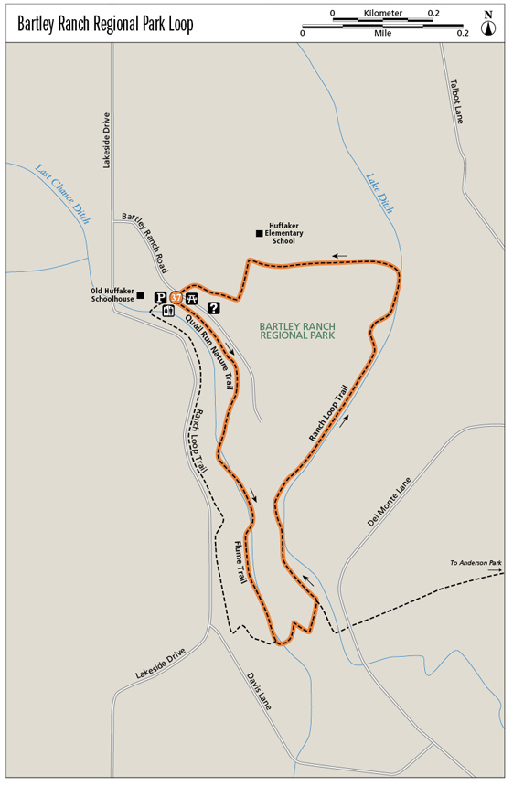
Bartley Ranch Regional Park Loop
Remnants of Nevada’s ranching heritage are preserved in this large suburban park. The trail begins next to a charming one-room schoolhouse, rides for a stretch atop a wooden flume, and meanders among farm equipment near trail’s end.
Start: At the signed trailhead in the parking lot near the Old Huffaker Schoolhouse
Distance: 1.5-mile loop
Hiking time: About 1 hour
Difficulty: Easy
Trail surface: Dirt, gravel, a short section of wooden flume
Best seasons: Spring, fall, and winter
Other trail users: None on the Quail Run and Flume Trails; equestrians and mountain bikers on the Ranch Loop Trail
Trailhead amenities: Parking, restrooms, water, picnic facilities; equestrian arena; an information center is located just down the trail from the parking area
Canine compatibility: Leashed dogs permitted
Fees and permits: None
Schedule: As a rule of thumb, Washoe County Parks are open from 8 a.m. to sunset. Formal hours are 8 a.m. to 9 p.m. from Memorial Day weekend to Labor Day weekend; 8 a.m. to 7 p.m. from Labor Day to the start of standard time; 8 a.m. to 5 p.m. from the start of standard time to the start of daylight savings time in spring; and 8 a.m. to 7 p.m. from the start of daylight savings time to Memorial Day weekend.
Maps: USGS Mount Rose NE NV; a map is posted on the exterior wall of the information center; www.nvtrailmaps.com
Trail contact: Bartley Ranch Regional Park, Washoe County Department of Regional Parks and Open Space, 2601 Plumas St., Reno, NV 89509; (775) 823-6500; www.washoecountyparks.com. The park’s direct line is (775) 828-6612.
Finding the trailhead: From US 395/I-580 southbound, take the Kietzke Lane exit (exit 63). Stay left, following Kietzke Lane for 0.1 mile to South McCarran Boulevard. Turn right (west) on South McCarran Boulevard and continue for 0.7 mile to Lakeside Drive. Go left (south) on Lakeside Drive for 0.4 mile to Bartley Ranch Road on the left (east). Follow Bartley Ranch Road for about 0.1 mile to the park entrance at the covered bridge. Park in the first lot, near the Old Huffaker Schoolhouse. The trailhead is next to the restrooms. The park address is 6000 Bartley Ranch Rd. GPS: N39 28.125' / W119 48.424'
The Hike
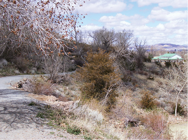
In Bartley Ranch, a backyard park in Reno’s southern suburbs, interlocking trails wind through native scrub, along irrigation ditches, and past preserved pieces of farm machinery. This loop, though never escaping the sight of private homes and the hum of highway noise, is able to evoke Reno’s frontier days by showcasing remnants of the past, including a covered flume and the perfectly restored Old Huffaker Schoolhouse. Take a peek inside the schoolhouse if it’s open. Clean and bright, with old-style desks and a glowing wooden floor, the building gives the impression of having absorbed the laughter of children into its sunshine-yellow walls.
Begin on the Quail Run Nature Trail, which passes through fragrant desert scrub and across several small wooden plank bridges to picnic sites fronting the Western Heritage Interpretive Center. The distant Virginia Range, brown and rolling in summer, fall, and much of winter, forms a backdrop to the park’s equestrian facilities and the Hawkins Amphitheater, which are located near the trail beyond the interpretive center.
In addition to hiking trails, Bartley Ranch Regional Park also has an interpretive center.
A short gentle climb leads to the Flume Trail; the neighboring Ranch Loop Trail rides the hillside above. Part of the Flume Trail is built on thick planks, silvered by weather, that cover the Last Chance Ditch. When the “boardwalk” ends, dirt singletrack parallels the now exposed ditch, which squirrels through a greenbelt of willows and piñon pines nurtured by the greenish-brown water.
The Flume Trail ends on the Ranch Loop Trail, where a bridge spans the ditch. Follow the Ranch Loop, which switchbacks downhill to the Anderson Trail (to Anderson Park) and past the end of the Quail Run Trail. The route then skims the fence lines of neighboring private pastures. Rusting farm implements—a wagon frame from Reno’s Flindt Ranch, a hay loader, rakes, a Jackson fork with a Mormon hay derrick, a manure spreader—line the track, and interpretive signs provide information on their origins and uses.
Toward the end of the hike, the Ranch Loop arcs west, back toward the interpretive center and Old Huffaker Schoolhouse, skirting an adjacent neighborhood park (with a tot lot), and the modern Huffaker Elementary School. Views west climb over adjacent development to the high peaks of the Carson Range, snowcapped in winter and spring. The final stretch of trail leads through developed areas of the park—parking lots near the interpretive center and the like—before depositing you at the schoolhouse trailhead.
Miles and Directions
0.0Start at the signed trailhead for the Quail Run Nature Trail and the Ranch Loop Trail. Climb three steps and go immediately left (southeast) on the Quail Run Nature Trail.
0.1Stay right (south) on the Quail Run Nature Trail where a side trail drops to the interpretive center. Cross the ditch to another trail crossing, again staying right (up and south) on the Quail Run Nature Trail.
0.3Reach the junction with the Flume Trail. Go right (south) on the wooden planks.
0.5Meet the Ranch Loop Trail at the end of the Flume Trail. Go left (east) over the bridge on the Ranch Loop Trail.
0.6Arrive at the Anderson Trail intersection and stay left (north) on the Ranch Loop Trail.
0.7Pass the end of the Quail Run Nature Trail, staying right (north) on the Ranch Loop Trail, toward a fenced pasture. At the next Ranch Loop Trail junction, about 50 yards beyond at the fence and wagon frame, stay right again, passing a hay loader alongside the Lake Ditch.
1.0At an unmarked trail junction amid a collection of ranching machinery (including the Jackson fork), stay right (north) and circle through a picnic area. The left-hand trail leads toward the riding ring. About 100 yards farther, a trail sign points you right (north). Hike through a dry streambed to a T junction. Go left (west) on the trail; a wire fence runs alongside.
1.2A paved path leads right (north) into an adjacent neighborhood park. Stay straight (west) on the Ranch Loop Trail.
1.3A second trail breaks right (north) onto the fenced school property; the equestrian parking area is on the left (south). Bear left (southwest) across the lot, then across a bridge, to the Western Heritage Interpretive Center. Turn right (west), crossing another small parking lot at a covered picnic area to a gravel path that leads back toward the schoolhouse and trailhead.
1.5Cross the main park road and follow the gravel path back to the trailhead.
Hike Information
Local information: The Chamber, serving Reno, Sparks, and northern Nevada, offers information and links to community events, government, and businesses including restaurants and lodging. The Reno office is at 449 S. Virginia St. 2nd Floor, Reno, NV 89501; (775) 636-9550; www.thechambernv.org. For information about the city of Reno, call Reno Direct at (775) 334-INFO, or visit www.reno.gov/index.aspx?page=1.
Restaurants: Hiroba Sushi Restaurant, 3005 Skyline Blvd. #100, Reno, NV 89509; (775) 829-2788. The restaurant offers delicious, inexpensive sushi and creative rolls.
Local events/attractions: Park facilities, including the Old Huffaker Schoolhouse, the Western Heritage Interpretive Center, and the amphitheater, can be rented for private functions. Equestrian arenas are also available. Contact the park for more information.
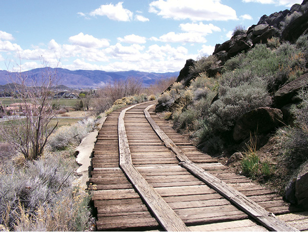
A covered wooden flume forms the trail for a portion of the loop through Bartley Ranch Regional Park.
Green Tip:
Err toward safety In areas where dogs are permitted to run off-leash. Keep your dog restrained unless you are certain it will follow your voice and sight commands. Even then, keep the leash handy and your dog in sight. Do not let it approach other people and their pets unless invited to do so.