Cradled in a shallow canyon rimmed with neighborhood homes, the Lower Whites Creek Trail aspires to (and eventually reaches) the high country.
39
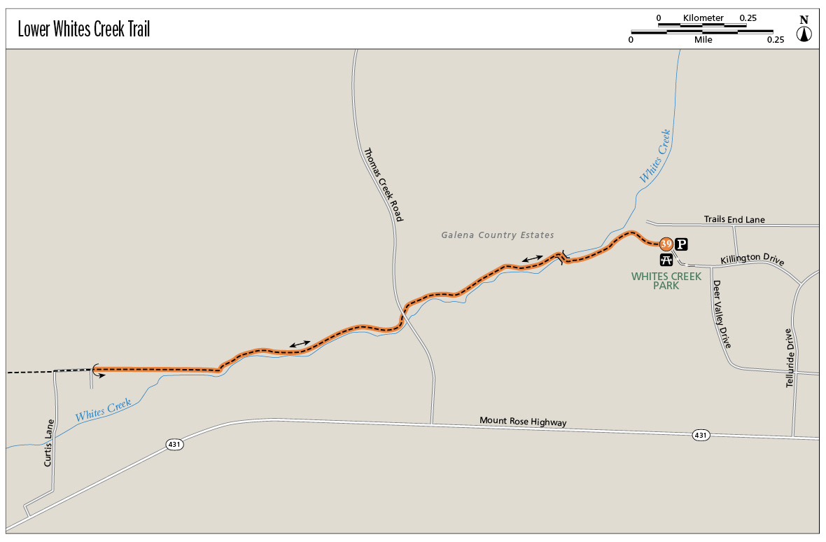
Lower Whites Creek Trail
This neighborhood treasure is tucked in a ravine surrounded by quiet residential subdivisions. Whites Creek supports a riparian habitat that envelops hikers in an unexpected, if narrowly defined, strip of desert wildland.
Start: At the trailhead in Whites Creek Park
Distance: 2.8 miles out and back
Hiking time: About 2 hours
Difficulty: Moderate due to steady incline
Trail surface: Dirt singletrack
Best seasons: Winter, spring, and late fall; avoid the heat of the day in summer
Other trail users: Mountain bikers, equestrians (no horse trailer parking), trail runners
Trailhead amenities: Parking, a tot lot, picnic facilities, a fenced playing field
Canine compatibility: Leashed dogs permitted
Fees and permits: None
Schedule: As a rule of thumb, Washoe County Parks are open from 8 a.m. to sunset. Formal hours are 8 a.m. to 9 p.m. from Memorial Day weekend to Labor Day weekend; 8 a.m. to 7 p.m. from Labor Day to the start of standard time; 8 a.m. to 5 p.m. from the start of standard time to the start of daylight savings time in spring; and 8 a.m. to 7 p.m. from the start of daylight savings time to Memorial Day weekend.
Maps: USGS Mount Rose NE NV; downloadable map at www.nvtrailmaps.com
Trail contact: Whites Creek Park, Washoe County Department of Regional Parks and Open Space, 2601 Plumas St., Reno, NV 89509; (775) 823-6500; www.washoecountyparks.com
Finding the trailhead: From US 395/I-580 southbound, take the NV 431 (Mount Rose Highway) exit. Follow Mount Rose Highway west for 2 miles to Telluride Drive (the second turnoff into Galena Country Estates). Turn right (north) on Telluride Drive and go 0.2 mile to Killington Drive. Turn left (west) on Killington Drive; the road ends in 0.2 mile at Whites Creek Park. Continue on the unpaved park road for 0.1 mile, past the fenced ball field, to the parking area at the trailhead. GPS: N39 23.786' / W119 47.980'
The Hike
The trail that follows Whites Creek is the perfect quick escape. Whether you’ve got an hour before work for a brisk workout, time after dinner for a leisurely wander, or want to spend a Saturday afternoon on the trail, a hike on the creekside trail, which winds through subdivisions at the base of Mount Rose, is both soothing and invigorating.
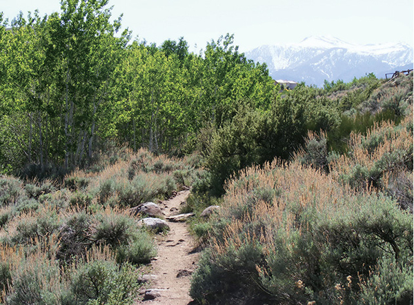
The trail begins in the dense riparian zone that thrives on the margins of the creek. Of all the foliage clogging the streamsides, perhaps most striking are the aspens, with leaves that are electric green in springtime and wedding-ring gold in autumn. Wildflowers (notably wild rose), stately cottonwoods, and tangles of willow clutter the banks as well, while the drier slopes of the gully walls are cloaked in desert scrub. Ringing the creek canyon on either side are neighborhood homes, their backyards sloping steeply to meet the creek.
The route boasts views too—of Mount Rose and the lower peaks of the Carson Range as you head west, and of the southern reaches of the Truckee Meadows on the return trip.
Cradled in a shallow canyon rimmed with neighborhood homes, the Lower Whites Creek Trail aspires to (and eventually reaches) the high country.
The trail starts on the south side of the stream—boisterous in spring and early summer and dwindling to pools and trickles in summer and fall. Within the first 0.5-mile the route crosses the creek via a pair of small wooden bridges to the north side. A word of route-finding caution: Social trails on the south side may lead you past the turnoff to the bridges. If you end up climbing out of the canyon onto a neighborhood road, backtrack to the first bridge you reach.
Once on the north side of the stream, climb steadily toward the mountains. While occasionally the riparian veil hides the houses that frame the creek, there is no escaping suburbia when the trail crosses four-lane Thomas Creek Road (there is no crosswalk, so be careful). The trail drops streamside again on the other side of the roadway, tucking quickly back into the riparian zone.
Gentler climbing through willow and scrub, with short side trails dropping to creekside rest stops, leads to a fenced zone where waterside access is denied. A final climb takes you up and out of the drainage onto a dirt road at the entrance to private property: In 2010, a sign posted on the fence declared if you can read this you’re in range. This is the turnaround point . . . unless you are prepared to take on a much longer trek, as the trail continues toward Mount Rose and links with the popular Jones-Whites Creek Loop.
Retrace your steps to the trailhead.
A variety of invasive and native species make up the flora of the riparian zones along creeks and streams throughout the Truckee Meadows. Among the plants once utilized by native peoples as medicine, food, or for ceremonial purposes are willow, wild rose, sage, mullein, chicory, and soaproot.
Miles and Directions
0.0Start behind a large pine, following the trail best traveled into the creek canyon. Stay left (west) where a side trail breaks right (north) to diversion channels.
0.2Arrive at the first bridge crossing on the right (north). Cross here or continue to the next bridge.
0.3Reach the second bridge spanning the creek, this one made of less substantial boards. If you haven’t already crossed, this is your last chance. Continue west on the trail on the north side of the stream.
0.8Cross Thomas Creek Road and continue on the signed trail.
1.2Reach the boundary of a fence that blocks access to the creek.
1.4Arrive at the turnaround point on the unpaved neighborhood road. Then retrace your steps.
2.8Arrive back at the trailhead.
Hike Information
Local information: The Chamber, serving Reno, Sparks, and northern Nevada, offers information and links to community events, government, and businesses including restaurants and lodging. The Reno office is at 449 S. Virginia St. 2nd Floor, Reno, NV 89501; (775) 636-9550; www.thechambernv.org. For information about the city of Reno, call Reno Direct at (775) 334-INFO, or visit www.reno.gov/index.aspx?page=1.
Restaurants: I’ve been in a few Whole Foods Markets across the West, but Reno’s store stands out. It is enormous, colorful, and loaded. The trail mix bar is a highlight for hikers, where you can build your own mix of nuts, seeds, dried fruit, and chocolate chips for the trail. Not your ordinary GORP. The store is located at 6139 S. Virginia St. in Reno; (775) 852-8023; www.wholefoodsmarket.com/stores/reno/. Hours are from 8 a.m. to 10 p.m., seven days a week.
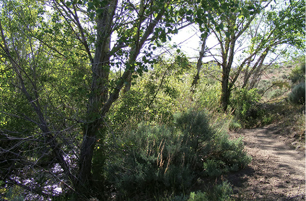
The riparian corridor watered by the lower reaches of Whites Creek provides shade for the trail.