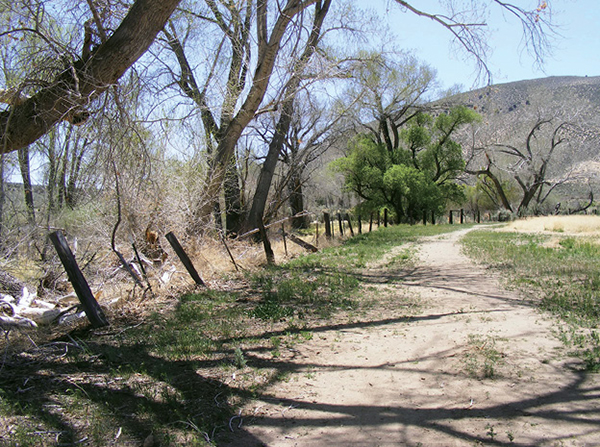
Ranch roads serve as trails that follow the Carson River downstream to the Mexican Dam.
44
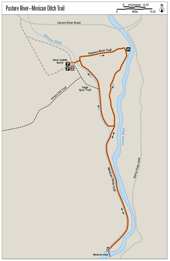
Pasture River–Mexican Ditch Trail
This meditative hike in the heart of the Carson Valley links the pastures of a working ranch to an historic diversion dam on the Carson River.
Start: At the signed trailhead near the Silver Saddle Ranch buildings
Distance: 3.6-mile lollipop
Hiking time: 2.5 to 3 hours
Difficulty: Moderate
Trail surface: Mostly dirt ranch road; some dirt singletrack
Best seasons: Winter, spring, and late fall. You’ll find shade along the river and the ditch, but the hike may be uncomfortably hot in summer at midday.
Other trail users: Mountain bikers, equestrians, trail runners, birders
Trailhead amenities: Parking, restrooms, and an information signboard at the trailhead. A handicapped-accessible restroom is located farther along the park’s loop road.
Canine compatibility: Leashed dogs permitted
Fees and permits: None
Schedule: 7 a.m. to 5 p.m. daily, year-round
Maps: USGS New Empire NV; trail maps are in the red mailbox at the trailhead
Trail contact: Silver Saddle Ranch operates under a cooperative agreement between the Bureau of Land Management and the Carson City Parks and Recreation Department. Bureau of Land Management, Carson City District Office, 5665 Morgan Mill Rd., Carson City, NV 89701; (775) 885-6000; www.blm.gov/nv/st/en/fo/carson_city_field.html. Carson City Parks and Recreation Department, 201 N. Carson St., Carson City, NV 89701; (775) 887-2262; www.carson-city.nv.us or www.carson.org/Index.aspx?page=1203
Special considerations: Several signs warn of frequent rattlesnake sightings. If you don’t bother them, they’re not likely to bother you. Keep your pet on a leash. Do not swim in the ditch; the water moves deceptively fast. So does the Carson River when swollen with runoff in spring.
Other: This is a working ranch, so be sure to close gates behind you or leave them open as instructed by signs or the ranch manager.
Finding the trailhead: From US 395/I-580 in Carson City, take the Fairview Drive exit (the end of the freeway in 2012). Go left (east) on Fairview Drive for 1.2 miles to the roundabout. Bear right on East Fifth Street. Follow East Fifth Street for 0.2 mile to Carson River Road (NV 513). Turn right (south) on Carson River Road and drive 1.3 miles to the signed park entrance on the right (south). Follow the park road (which becomes one way) around to the ranch complex and trailhead. GPS: N39 08.320' / W119 42.699'
The Hike
This pleasant ramble through Silver Saddle Ranch and along the Carson River begins amid hay fields that are irrigated with water from the Mexican Ditch. If the fields have gotten water, they grow lush and green. If they haven’t, native sages, bitterbrush, and desert peach reclaim the fallow space.
Transforming high desert into cultivated farmland seems simple enough on the Silver Saddle Ranch: Open a gate on the ditch and let the water flow. But water in the West is treasured, measured, and fought over, and winning the battle for water rights can make or break any project, whether spearheaded by a city or by a family farm. The water in the Mexican Ditch comes from the Carson River; from the ditch the water is divided between private and public lands in the agricultural bottomlands of the Eagle Valley, with flows gauged as carefully now as they were a century ago.
Built in the early 1860s, the Mexican Dam and Ditch initially supplied water to power the ore-crushing wheels of the Mexican Mill, part of a complex of mills that processed the output of Nevada’s fabled Comstock Lode. But even before the lode played out, water from the ditch was being diverted for agriculture, according to the Friends of Silver Saddle Ranch. That conflict drove one of the aforementioned water rights battles: Miners and ranchers duked it out in court over the precious resource. The demise of the Comstock ultimately decided the winner, with agriculture and development taking shares of Mexican Ditch water in the wake of mining’s decline.
These days the ditch carries water to valley ranchers even when the hot summer whittles down flows in the Carson River. On Silver Saddle Ranch the Mexican Ditch also leaches enough moisture into the dry desert soils to support a riparian strip ringing with birdcall. The trail that runs alongside the ditch attracts bird-watchers as well as mountain bikers, trail runners, and day hikers.
The route begins amid Silver Saddle Ranch’s red-painted buildings; if you are lucky, the ranch manager will be on hand to give you advice about the route. Interpretive signs around the ranch give information about the Mexican Ditch and the ranch property itself.
Ranch roads serve as trails that follow the Carson River downstream to the Mexican Dam.
From the ranch you will pick up the Pasture River Trail, a straight shot that leads along the north side of one of the fenced hayfields to the banks of the Carson River. A small picnic area shaded by cottonwood sits riverside, possibly occupied by picnickers and anglers. Head south along the ranch road that runs between the river and the pastures, passing through a couple of gates. An avenue of cottonwoods provides shade as you proceed.
After 1 mile pass a gate and an interpretive sign that describes the “ribbon of green” that is the Carson River in all seasons, whether full and swift with winter runoff or dried to fish-clumped puddles in fall. Drop to riverside, staying left on a sandy road through the bottomlands (which can be wet in spring), then climb to the junction with the Mexican Ditch Trail.
Head south on the flat dirt road, which is wedged between river and ditch. Quail scurry from bush to bush on the riverside, lizards scamper from rock to rock on the ditch side, and songbirds flit from branch to branch in the cottonwoods and willows. You may spot anglers scattered along the far shore, but unless the birders are out, you may have the trail to yourself.
The muffled thunder of water spilling over the diversion dam wafts up the route long before you arrive. The dam marks trail’s end; in spring it overflows in a 10-foot whitewater fall that spans the Carson River from bank to bank but diminishes as the summer progresses. The Carson pools behind the structure, widening between shallow slopes covered in desert scrub. The gate that funnels water into the ditch is on the right (west); when the Carson begins to dry, sandbags are used to divert the flow into the ditch.
The dam is the turnaround point; retrace your steps to the junction of the Mexican Ditch Trail and the Pasture River Trail. To complete the loop portion of the hike, stay left (northwest) on the ditch trail, following the green strip alongside pastures as you hike back to the ranch complex and trailhead. Enjoy views of the Carson Range and Slide Mountain as you return.
A quote from Mark Twain posted on an interpretive sign along the Mexican Ditch in Silver Saddle Ranch: “Whiskey is for drinking, water is for fighting.”
Miles and Directions
0.0Start by walking through the ranch property to the fence line of the first hayfield. Go left (north) along the fence to the signed Pasture River Trail, then head east toward the river.
0.4Reach the gate and picnic site on the bank of the Carson River. Turn right (south) on the wide track.
0.6The trail narrows and passes through a gate. Remain on the obvious path along the fence line.
0.7Pass another gate and into a second pasture. Stay left (riverside) on the main ranch road/trail, ignoring side roads.
1.0Reach a gate and an interpretive sign. Pass through the gate (if open) or the stile (if closed) and follow the sandy road that drops left (riverside) then climbs to the junction with the Mexican Ditch Trail.
1.2Go left (south) on the broad dirt Mexican Ditch Trail. The river is on the left (east) and the ditch is on the right (west).
2.0The trail swings around a curve in the river and ends at the Mexican Dam. Turn around and retrace your steps to the last trail junction.
2.8Back at the junction of the Mexican Ditch Trail and the Pasture River Trail, stay left (north/on the high road) on the Mexican Ditch Trail.
3.0Carefully cross the ditch overflow and continue on the dirt road to the gate/stile at the interpretive sign. Stay left (northwest), following the pasture’s fence as it curves along the ditch.
3.3Pass the gate and bridge of the Silver Sage Trail on the left (west). Stay right (northwest) on the Mexican Ditch Trail.
3.4Pass a gate into another hayfield; at the intersection of the ranch roads stay left (straight/north) on the ditch trail. Cross an irrigation ditch and go through another gate as you approach the ranch complex.
3.6Arrive back at the trailhead.
Hike Information
Local information: The Carson City Chamber of Commerce provides information for both residents and visitors about amenities in the city and environs, including places to stay and places to eat. For more information contact the chamber at 1900 S. Carson St., Suite 200, Carson City, NV 89701; (775) 882-1565; www.carsoncitychamber.com.
The Carson Valley Chamber also provides information for residents and visitors to Carson City, Minden, Gardnerville, and other valley cities and towns. Contact the chamber at 1477 US 395, Suite A, Gardnerville, NV 89410; (775) 782-8144 or toll free (800) 727-7677; www.carsonvalleynv.org.
Organizations: Members of the nonprofit Friends of Silver Saddle Ranch provide interpretive programs and perform maintenance projects and other support services at the ranch. For more information visit fossr.org.
Green Tip:
Never let your dog chase wildlife.