See also Ord Road and Magazine Road
The A.B.C. Bridge was first recorded cartographically in several maps (1868, 1878) and the 1881 ‘Map of Singapore Town” by the Acting Colonial Engineer and Surveyor General Captain H.E. McCallum under Governor Frederic A. Weld. The reference to A.B.C. Bridge and Road has no written records as to the origins of its name. It was the bridge between the British military ordnance and ammo stored at Magazine Road as well as the Municipal store located here and at Fort Canning.
Except for the 1881 Map, none of the earlier or later Maps of Singapore refer to the A.B.C. Bridge and Road – partly because both the Road and Bridge names were probably colloquial references at that time. The bridge was once also called Toddy Bridge because of the many toddy shops located nearby. In the Minutes of the Municipal Commissioners meeting of 20 January 1886 chaired by Major McCallum it was decided that A.B.C. Road was to be renamed Ord Road. The Road was named after Colonel Sir Harry St George Ord (1819-85), the first Governor of the Straits Settlement (1867-73) and was opened on 22 July 1886 by Governor Sir F.A. Weld. The new Bridge which was an extension of Ord Road was designated Ord Bridge in the 1886 minutes.
The area around the bridge was known as ong ke sua kha thih chio in Hokkien, which means “iron foundry at foot of Fort Canning”.
SOURCE: Hall, 2011 personal communication; National Heritage Board, 2006:27; McCallum (1881) Map of Singapore Town; Straits Times Weekly, 1886:7
ABC Bridge
An enlarged section of an 1881 map showing the ABC Bridge linking Riley Hargreaves & Company’s iron foundry and Hong Lim Quay/Magazine Road.
This mosque is named after Shaik Abdul Gapore Bin Shaik Hyder, a Tamil clerk in the firm Khong and Bridges, Advocates and Solicitors. The area (mosque property or wakaf) was developed in the late nineteenth century (c. 1884). The present mosque was built in 1907. Gapore (now Gaffoor) was the mosque trustee from 1887. In the late nineteenth century, the mosque catered to Indian Muslim merchants, Baweanese stablemen and horse trainers in the nearby race course (Farrer Park). It is the only mosque in Singapore with a sundial. After major restoration works in 2003, the mosque now accommodates 4,000 worshippers.
SOURCE: Siddique and Purushotom, 1982:55-56;
Preservation of Monuments Board, 2009:65
This colonial bungalow houses the Shooker Welfare Home for elderly Jews in Singapore. The house and welfare home comes from funds from the Abdullah and Flora Charitable Trust. Abdullah Salleh Shooker (1849-1942), a Baghdadi Jew, was an extremely successful businessman who worked for Manasseh Meyer before opening his own business at Malacca Street (Raffles Place area). He was the first Jewish casualty of the Japanese occupation in Singapore. During his lifetime, Shooker lived at 1 Oxley Rise. Both Abdullah and Flora left wills for the poor, sick or indigent Jews in Singapore, Palestine and Baghdad.
SOURCE: Bieder, 2007: 170-171
This road was officially named in 1922 after Frank Adam, former managing director of Pulau Brani Tin Smelting Works and onetime president of the St Andrew’s Society for over five years.
Adam Park is the only World War II battlefield that has survived almost intact. In February 1942, the Battle of Adam Park saw some of the fiercest fighting. The house at Number 7 Adam Park, the current National University of Singapore Society (NUSS) club house was the headquarters of the 1st Battahorn, Cambridgeshire Regiment.
SOURCE: ARSM ASD, 1922:4A; Raja-Singam, 1939:79; Lee Kip Lee’s notes.
The current Adelphi Building is the site of two former houses built by George Coleman in the 1830s. Sir John Peter Grant, a Calcutta Magistrate used to spend his vacations in Singapore, and Coleman built him a house in 1836 (and remodelled it in 1840) called the “Grant House”, where the current Adelphi Building is located.
The Adelphi Hotel was first established in Raffles Place in 1863 and later relocated to High Street and finally to Coleman Street. The Adelphi Hotel was a landmark hotel, which changed ownership from Armenians to Jews at the turn of the 20th century. For 11 years beginning from March 1903, Arathoon M. Sarkies and Eleazar Johannes took over the lease of the Hotel. After major renovations, the hotel in 1908 had become “one of the best known and most popular hotels in Singapore”. When the Sarkies, Johannes & Company collapsed, Jacob Carapiet took over the hotel until 1914 when he filed for bankruptcy. The hotel was later owned by Jewish businessman and property holder, Manasseh Meyer. Adelphi Hotel was pulled down in 1980 and made way for the current Adelphi Building, known for its high-end audio equipment specialists.
SOURCE: Hancock, 1986:53-54
In 1905, this road between two former houses (numbers 83 and 97) in Sophia Road was named after Nissim N. Adis, the son of a Calcutta merchant, and who was married to Leah Judah, the granddaughter of B.R. Belilious of Hong Kong. In 1907, Nissim Adis built a fine mansion on top of Mount Sophia and called it the Adis Lodge. The road leading to it became Adis Road as the Municipal Council allowed Nissim Adis to name his private road leading from Sophia Road to his house. Adis Lodge became legendary and was described as “one of the most magnificent mansions east of Suez”. It was eventually sold to the wealthy Chinese businessman Eu Tong Sen. Eu Villa, built around 1917, was demolished in 1980.
Nissim Adis was connected with the old Grand Hotel de l’Europe. Part of the hotel building was also called the Adis Building after its owner. Adis installed an Otis lift, which was one of the first of its kind to serve the three floors and roof garden. The Grand Hotel was known for its food and hence Somerset Maugham noted that one may stay at the Raffles but dine at the Grand. The Hotel was pulled down in 1900 to make way for the former Supreme Court building.
SOURCE: MPMCOM, 1 Dec 1905; Edwards & Keys, 1988:253, 375; Nassim 1986: 22-23; Singapore Free Press, 1905
See Sembawang and Seletar
This road name reflects the area’s association with the large British Naval Base (in the Sembawang area) that was established between 1923 and 1941. Given that the residence of the Rear Admiral of the British Navy was located in this area, the road name probably reflects the Naval High Command. When the British began the construction of the Naval Base they laid out and developed Admiralty Road in 1923 which ran through the Naval Base area. The base was the key British installation in the region and was projected as the Asian bastion of the British Empire between the world wars.
Many of the roads in this area are evocative of the British Empire: Auckland, Bermuda, Canada, Cyprus, Durban, Delhi, Deptford, Falkland, Fiji, Gibraltar Crescent, Hobart, Jamaica, Kenya Crescent, King’s Avenue, Kowloon, Lagos Circle, Madras, Malta Crescent, Montreal, Ottawa, Pakistan, Queen’s Avenue, St. Helena, St John’s, Sudan, Tasmania and Wellington.
Admiralty House was designed by Edwin Lutyens (1869-1944) and served as the strategic planning headquarters of the British armed forces. This is a house with the most changes of names: Old Admiralty House was called Canberra House (1939-45), Nelson House (1945-58), Admiralty House (1958-71), Anzuk House (1971-75), Yishun Country Club (1991-2001) and from 2002 it was renamed Old Admiralty House and gazetted as a national monument.
SOURCE: Edwards & Keys, 1988:76
This road was named after Wee Ah Hood (1828-75), a wealthy Teochew businessman who ran a shop, Chop Hoon Hong, at Telok Ayer Street. Besides his general merchant shop, Ah Hood also owned several large gambier and pepper estates. Ah Hood’s house (built in 1878) was located in what is today the site of the Chinese Chamber of Commerce building (Hill Street). The Chinese Chamber first leased the house in 1906 and finally bought it in 1911.
SOURCE: Buckley, 1984:102-03; Edwards & Keys, 1988: 367
See Opera Estate
This is one of several roads in Opera Estate which drew its inspiration from western operas. Others include Tosca, Carmen, Swan Lake and Fidelio Streets.
This road is named after a port in the western coastal area of Burma, now Myanmar. The peculiarity of the area is the number of Burmese place names in fairly close proximity, including Ava, Bhamo, Bassein, Irrawaddy, Mandalay, Martaban, Pegu, Prome and Shan. Other roads having toponymical similarity but located some distance away include Rangoon, Mergui and Moulmein roads. The idea came from an old and respected Burmese resident who suggested it to the Municipality, which accepted the idea. It is likely that the respected Burmese resident was U Kyaw Gaung, a Burmese practitioner of traditional medicine who was also the founder of the Burmese temple in 1921. He had influenced the authorities about using Burmese place names in the street names of the area. The other view is that the Burmese road names reflect the influence of the old Burmese temple (Maha Sasana Ramai Burmese Buddhist Temple) located originally at 17, Kinta Road.
SOURCE: Ramachandran, 1969; National Heritage Board, 2006a
This street was named after Prince Albert, consort to Queen Victoria, in March 1858 by the Municipal Commissioners. Albert Street in the early days was part of Kampong Bencoolen, an area occupied by Muslims from Bencoolen, Sumatra. In the Chinese vernacular, the street used to be known as kam kong mang ku lu (Kampong Bencoolen), or sometimes bo moa iu koi (the street where oil is expressed from sesamum). In the early nineteenth century, Hindus held their fire walking ceremony in Albert Street before it became a regular ritual at the Sri Mariamman Temple on South Bridge Road. Tamils thus used to call this street thimiri thidal (the place where people tread on fire).
From a culinary perspective, this street is best remembered for the Chinese restaurant, Wing Seong (184 Albert Street), better known as Fatty’s Restaurant because of the Buddha-like figure of Au Chun Seng, the owner. The restaurant opened in 1918, beginning with Au Yuen, followed by his son Au Chun Seng and now the grandson, Au Kok Weng. In July 1986, Fatty’s Restaurant moved from its shophouse location to the air-conditioned Albert Complex.
SOURCE: Buckley, 1984:667; Edwards & Keys, 1988:282; The Straits Times, 30 Mar 1986:1
For 25 years, Dr Albert Winsemius worked gratis for the Singapore government, drawing up 10-year development plans that transformed the island into today’s high-technology, high value-added industrial hub.
Prime Minister Lee Hsien Loong in a 2009 speech noted that Dr Winsemius “provided invaluable and wise advice in economic development and investment policy”.
In honour of his contributions, particularly between 1960 and 1985, Singapore named this road after the late Dutch economist. The road is located in the western part of the island and leads to the Aquatic Science Centre near Sungei Ulu Pandan.
SOURCE: The Straits Times, 23 October 2009.
Alexandra Road was first established by the British in 1864 connecting River Valley Road with Pasir Panjang, and was known as chui bo lai in Hokkien, meaning “within the water (rice) mill”. The road was officially named after Queen Alexandra, consort to King Edward VII. Alexandra Close was the name given in 1955 to a road leading into the newly-built Singapore Improvement Trust estate off Alexandra Road.
Around Alexandra and Ayer Rajah roads was the place of the 1915 mutiny by an Indian regiment – the 5th Light Infantry. Forty Caucasian (European/British) people were killed here by the Indian regiment leading Roland Braddell (1935) to note that “many ghosts must walk” this place.
SOURCE: Buckley, 1984:667; Edwards & Keys, 1988:282; Braddell, 1935:96
This park, named after Princess Alexandra, was the residential area of the British forces in Singapore (i.e., the Far East Land, Air and Sea Forces). The area was formerly a pepper plantation, with one house standing there from 1905. Most of the other houses in this residential estate were erected between 1935 and 1940. Some buildings were added later to house the army medical doctors and technicians from Alexandra Hospital. Established by the British, the Park followed the example of the original English garden suburb. The tree-lined roads here are named after places in Britain and the Commonwealth: Berkshire, Bury, Canterbury, Cornwall, Hyderabad, Winchester and York. During the Japanese Occupation of 1942-45, these houses were converted into Japanese medical officer barracks and an observation post. At this time, the tennis court was destroyed and air raid shelters were dug into the hill.
SOURCE: Edwards & Keys, 1988:317
See also Syed Alwi Road
Aljunied Road was officially named in 1926 after either Syed Omar bin Al AlJunied (Syed Umar ibn Ali al-Junayd) (d.1852) or his family members. Syed Omar Ali was the nephew of Muhammed ibn Harun al-Junayd, the first Arab to arrive in Singapore. Syed Mohammed bin Harun Al Junied came from Palembang to Singapore in 1819 and was said to be a close friend of Sir Stamford Raffles. Syed Omar was not only a wealthy Arab merchant from Palembang but also a highly respected man, looked upon by the Malays as a prince and considered a descendant of Prophet Mohammed, the founder of Islam. Syed Omar was a philanthropist and his charitable acts included donating a large plot of land in Victoria Street for the purposes of a Muslim burial ground and the construction of a mosque in Bencoolen Street. In 1927, one of his descendants, Syed Abdul Rahman, erected the Madrasah Aljunied Al-Islamiah on vacant ground next to the Victoria Road cemetery in commemoration of Syed Omar.
SOURCE: MPCOM, 28 May 1926; Tan, 1976/77:48; Buckley, 1988:563-4; Freigtag, 2002:115
See Alkaff Quay
This is the first of three footbridges built at the turn of the twentieth century. Shaped like a tongkang, the 55-metre long bridge is situated near the former Alkaff Quay. The Quay was named after a prominent Arab family, the Alkaffs (al-Kaf), who were among the wealthiest people in Singapore during the late nineteenth and early twentieth centuries. In 1888, the Alkaffs built the Arcade Building and founded the Hotel de l’Europe. By 1908, Alkaff & Company was probably one of the biggest property owners and tax-payers in Singapore. The current bridge was repainted in 2004 by Filipino artist Pacita Abad and her crew using 52 different colours and more than 900 litres of paint.
SOURCE: National Heritage Board, 2009; Freitag, 2002:113
The Alkaffs, or “al-Kaf” in Arabic (meaning ‘the sufficient’), were a prominent Arab family much associated with Singapore’s colonial history. Like most Arabs in Singapore, they came from the Wadi Hadramaut area, a poor region in the southern part of Yemen. The first member of the Alkaff family was Syed Mohammed bin Abdul Rahman Alkaff, a trader who specialised in the Singapore-Java trade. He also invested in land and houses in Singapore. Having no sons, his younger brother, Syed Sheik Alkaff, inherited his estate and business. This property and business was in turn handed over to Sheik’s son, Syed Ahamed bin Sheik Alkaff.
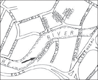
Alkaff Quay
A detailed section of a 1954 map showing Alkaff Quay along the south side of the Singapore River which is now the site of a condominium.
Alkaff Quay, on the south side of the Singapore River, was named in 1907 after Syed Sheik Alkaff, who also built the Arcade in 1888 where the ground floor was converted into garage for horse carriages. The building was sold to Woh Hup in the 1970s. The quay was named as such because it contained 17 godowns, which were the property of Alkaff & Company.
At Alkaff Quay, from Havelock Road, there was a small sampan, rowed by a Punjabi girl and her brother, which used to take passengers regularly across the Singapore River to Robertson Quay.
Alkaff Mansion was built for the Alkaff family as a holiday home in 1920. The house was built earlier but the current configuration (renovations) was done in 1926. The 7,000 sq ft house sat on 47 acres of land on top of Bukit Jagoh (now part of Mount Faber). The Alkaff Mansion was located on Mount Washington, or what is now called Telok Blangah Hill. Their family home was in Lloyd Road.
SOURCE: MPCOM, 13 Dec 1907; Buckley, 1984:564; Edwards & Keys, 1988:497; Freitag, 2002:124-125
This road was named after Field Marshal Viscount Alanbrooke (1883-1963). Field Marshal Alanbrooke was one of the Royal Artillery Regiment’s most distinguished officers. He served in India and the First World War. In the Second World War, he commanded a Corps with BEF in France and played a decisive role in the withdrawal from Dunkirk. He was appointed Chief of the Imperial General Staff in 1941, an appointment he held until 1946, making him one of the main architects of victory. He was the Master Gunner at St. James Park from 1946 to 1956.
This street in Jalan Besar was named after Edmund Allenby, 1st Viscount (d.1936), who served the British armed forces in South Africa (1884-85, 1888, 1889-1902), France (1914-17), Turkey and Egypt. He was made Field Marshal and High Commissioner for Egypt (1919-25). Following a 1926 municipal decision, several other roads in the Jalan Besar area were named in commemoration of World War I British and French generals and admirals, including Beatty, Foch, French, Jellicoe, Kitchener, Maude, Petain, Sturdee and Tyrwhitt, as well as battle places, as in Flanders, Marne, Somme and Verdon roads.
SOURCE: MPCOM, 5 Aug 1926; Raja-Singam, 1939:80; Ramachandran, 1969
This road was named after José de Almeida (1812-94). He lived on Mount Victoria and gave his name to the road at the foot of this mount. José is the youngest son of Sir José d Almeida Carvelho E. Silva (1784-1850), who was born in Macau, came to Singapore in 1825 and got married in 1845.
This road probably derived its name from the Chinese temple (ama keng) located in Lim Chu Kang. The temple, built in 1900, is dedicated to the “holy mother”, the goddess of peace and happiness. In the Fujian Chinese dialect, the word ama keng literally means “grandmother temple” (ama means “grandmother” and keng means “temple”). The first temple, made of wood and attap, was renovated in 1943 (zinc roof/timber structure) and again in 1965 (tile roof).
See Elias Road
This area and its roads were named after the Amber Trust Fund established by Serena Elias to enable poor Jewish youths to further their education.
When Serena died on 23 November 1925, she left a legacy of $15,000 in a Trust which was expanded by the Elias family. Aaron and Serena Elias had a large family of three boys (Joseph, Ezra and Issac) and three daughters (Becky, Esther and Miriam). One of her sons, Joseph Elias was an enterprising businessman who was involved in many business ventures in Singapore. His numerous business ventures included the production of bottled mineral water from the Seletar Hot Springs, the Tampines Tiles Limited, the Fresh Food and Refrigerator Company Limited, and the newspaper, the Malaya Tribune. The Elias family held property in the current Amber Road area. The name Amber Road was originally given to a road stretching from Grove Road (expunged) to Tanjong Katong Road in 1921, “with the view of simplifying the house numbering of the town”.
Kampong Amber was the name given to a Malay kampong sited between East Coast Road and Amber Road. It was demolished in the 1970s and 1980s to make way for blocks of high-rise flats. Amber Building on Malacca Street and Amber Mansions in Orchard (at the corner of Orchard Road and Penang Road) were also named after Serena Elias’ family.
SOURCE: ARSM ASD, 1921:3A; Lee Kip Lee’s notes; Bieder (2007):54-56
This is one of the old streets developed during the 1830s defining Chinatown under Raffles’ 1822 Plan. It was listed in Coleman’s 1836 Map of Singapore as Amoi Street, and was probably a reference to the many migrants who came from Amoy in China. During the colonial era, this street was famous for its opium smoking dens. The Chinese name for the street is based on landmarks in the area: it is called ma cho keng au in Hokkien (back of the Ma Cho temple), or kun yam miu hau kai in Cantonese (behind the Kun Yam temple), referring to the Thian Hock Keng Temple in Telok Ayer Street where both goddesses were worshipped. It is also known as ha mun kai in Cantonese, ha mun being the Cantonese pronunciation of the characters representing the name of the place Amoy. The street was also known colloquially as Free School Street or ghi oh khau (front of the school) because the Cui Ying School was built here in 1854. It was in one of the shophouses here (Number 70) that the first Anglo-Chinese School was started on 1 March 1886. The shophouse has since been marked as a historic site.
SOURCE: Firmstone, 1905:54-55; Edwards & Keys, 1988:457; The Straits Times, 1 Mar 1998:26; Oral History Department, 1990:26
A joint-venture between the colonial government and the Municipality, this bridge was erected between 1909 and 1910 after the reclamation of the south bank of the Singapore River, to replace an older, more crudely constructed one which was too low for vessels to pass under at high tide. The abutments were by the Westminster Construction Company Limited. The bridge became necessary due to the growth of vehicular traffic at the turn of the century. Cavenagh Bridge was congested with traffic and despite the building of Ord and Read Bridges the traffic situation did not improve and in fact worsened following the widening of Battery Road.
Finally, the Municipality decided to give up Cavenagh Bridge for vehicular traffic and Anderson Bridge took its place. It was officially opened on 12 March 1910 by Sir John Anderson, Governor of the Straits Settlements and High Commissioner for the Federated Malay States, after whom it is named. The bridge linked the business square (Raffles Place) to the government administrative area.
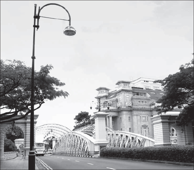
Anderson Bridge
Anderson Bridge combines plaster and metalwork in its construction and was built to take vehicular traffic from Cavenagh Bridge.
SOURCE: MPMCOM, 16 Apr 1909; Ramachandran, 1969; Edwards & Keys, 1988:414, 488
This road is named after Sir John Anderson, Governor of the Straits Settlements and High Commissioner for the Federated Malay States between 1904 and 1911.
See Caldecott Hill
This road is named after Sir Andrew Caldecott, a distinguished colonial administrator who served as acting Governor of the Straits Settlements and Colonial Secretary in the 1930s.
Early reference to Ang Mo Kio is found in Thomson’s 1849 report on Singapore’s agriculture. This New Town is located in the mid-northern part of the island. The Chinese name, amokiah, or Ang Mo Kio, literally means ‘red hair bridge’, a reference to the Europeans (derogatorily known as red-haired devils). The bridge in question was built by J.T. Thomson at Thomson Road. Ang Mo Kio is now dominated by a 730 hectare satellite town with over 200,000 residents.
SOURCE: Ramachandran, 1969; Thomson, 1849a
See Jalan Angklong
See Shepherds Drive
This road was one of several in the area named in 1955 after varieties of sheep, as it leads off Shepherds Hill.
Angsana Avenue, named after a local tree, is one of several roads in an area developed in the early 1950s as part of Sennett Estate, a middle-income housing estate. Other roads in the vicinity also named after plants include Belimbing, Butterfly, Camphor, Cedar, Chempaka, Kenanga, Lichi, Mulberry and Willow Avenues.
The theme was chosen by C.W.A. Sennett, the developer, in order to approximate a Malayan theme which he believed would be acceptable to the local population. The Municipal Commissioners approved the name in 1951.
SOURCE: MPMCOM, 14 Sep 1951
The area around Angullia Park was the former property of A.M.S. Angullia (d.1939), a prominent local-born Indian merchant and landowner. In 1897, Angullia had his house at the corner of the park.
One of the original members of the proposed Rate-Payers Association set up in 1915, he was also a Justice of Peace, thrice president of the Indian Merchants’ Association, a member of the Indian Chamber of Commerce, and a Municipal Commissioner who served for two years and five months from January 1911. Angullia Road (expunged) in the Rochor area is named after him as he owned the land here in 1903.
SOURCE: Raja-Singam, 1939:80
See also Kampong Malacca
This road is named after Gilbert Angus, a partner of Whampoa and Company at a time when it was under Whampoa (Junior), Hoh Ah Yip. Angus owned a number of nutmeg plantations around the Tanglin area in the nineteenth century and was also a Municipal Commissioner. His house, in the vicinity of Tanglin, was also name “Angus”.
The Chinese used to call this street kam kong ma lak kah or “Kampong Malacca”, after the general name for the surrounding area. The Chinese also referred to the street as sai tao xiang or sai tao street which possibly refers to the opera theatre called “Lao Sai Tao” located along Angus Street.
SOURCE: Firmstone, 1905:54-7; Raja-Singam, 1939:80; Braga-Blake & Oehlers, 1992:94; Mr Phua Tong Gek, Oral History Interview, Oral History Department
See Scott’s Hill; Gemmill Hill
Ann Siang Hill (off South Bridge Road) was named after the third owner of the land area, Chia Ann Siang (1832-92), who built his house on the site around his estate. Chia Ann Siang was a wealthy Hokkien Chinese sawmiller. Ann Siang joined Boustead and Company in 1848 and later became its chief produce storekeeper. He retired in 1890 after over 40 years of service in the company. He was also a partner in 1863 in the firm Geok Teat & Company, and a wealthy landowner.
Before Ann Siang bought the area, the Hill was known as Gemmill’s Hill after John Gemmill, a merchant and former auctioneer, and before that Scott’s Hill, after its original owner Charles Scott, who cultivated nutmegs and cloves in the area. The foot of the area between Ann Siang Hill and Mount Erskine (where South Bridge Road meets Neil and Tanjong Pagar roads, the site of the Metropole Theatre, now a church) was one of the earliest Cantonese Chinese burial grounds. The graveyard was in use up to 1867, exhumed in 1907 and part of the area, together with Mount Wallich, used for the Telok Ayer reclamation project. The Chinese used to call this area qing shan ting.
SOURCE: Archives & Oral History, 1983:11; Raja-Singam, 1939:81; Song, 1984:420-41; Edwards & Keys, 1988:452
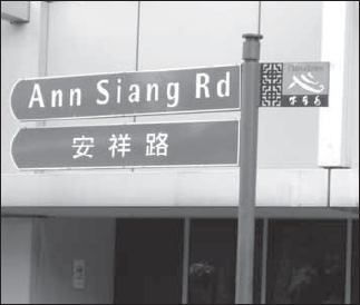
Modern day street sign for Ann Siang Road. Photo by National Library Board. All Rights Reserved. National Library Board, Singapore 2013.
The street is named after Annamalai Chettiar, who was responsible for setting up the Natukottai Chettiar’s Trade Association in Tank Road in the 1920s. Mr Annamalai had his early education in his hometown of Ramachandrapuram in Tamil Nadu, India and was well versed in English. He was known for his philantropy within the Chettiar community in Singapore and Malaya. The street is named after him because he owned several properties in the Sixth Avenue area.
SOURCE: Sukumar E., personal communication
Anson Road is named after Major General Sir Archibald E.H. Anson, who administered the Straits Settlements during the interim periods between Governors in the 1870s. He was later appointed Lieutenant Governor of Penang and retired in 1882. Traditionally, the street is called lau tua peh kong hit tiau (old idol street), referring to an old temple in the Tanjong Pagar vicinity.
The Anson Road grounds were well-known before World War II as it was there that the Malaya-Borneo Exhibition was opened by the Duke of Windsor (then Prince of Wales) in 1922. After the exhibition the grounds became the Happy Valley, precursor of Singapore’s three local amusement parks (Gay World, Great World and New World). The entertainment centre was operated by Lim Teck Kim and Lim Hoe Chiang, brothers whose names are commemorated by roads bearing their names off Tanjong Pagar Road. Show business competition led to the Happy Valley’s closure. The grounds then became a football stadium, forerunner of the Jalan Besar Stadium. On 15 March 1902, Loke Yew invited tenders to build 23 houses in Anson Road, Patani Street and Deli Street.
SOURCE: Firmstone, 1905:56-57; Hale, 2011, personal communication
This road could have been named after a Mr Anthony of the Federated Malay States Railway, a former Colonial Treasurer of the Straits Settlements, or a member of a local Armenian family.
SOURCE: Raja-Singam, 1939:81
Two explanations exist for the name Arab Street. The first is that the whole area used to be owned by an Arab merchant, Syed Ali bin Mohamed Al Junied (Muhammad ibn Harun al-Junayd), and was the site of the Arab kampong, hence the name Arab Street. In 1822 when Raffles formed a committee to map out quarters of potential immigrants, Muhammad Aljunied was the only Arab on the committee. The committee had set aside an Arab quarter next to the Sultan’s palace. The Arab population in Singapore numbered 15 in 1824, 115 in 1860, 465 in 1871, and 919 in 1901. The Chinese traditionally referred to the street as jiau a koi (Javanese street), in view of the Javanese who used to be its chief inhabitants. In Tamil, Arab Street is pukadai sadkku (flower shops street), because of the home grown flowers, lime fruit and other goods sold by Javanese women. A great fire occurred here in 1889.
The second explanation is tied to the situation already pre-existing at the time of Singapore’s founding by Sir Stamford Raffles. When Raffles was planning the broad outline of areas to be allocated for government, as opposed to commercial and residential use, a small community of Bugis seamen and merchants was already in existence near the Sultan’s compound at Kampong Glam. Raffles therefore allocated this area to them, near where their boats were sheltered in the river, bringing in their annual cargo on a barter basis; hence Bugis Street came into being. The Arab and other Mohamedan traders (Chulias, or natives of Madras) were also allocated areas near Kampong Glam. Arab Street can also trace its name to this arrangement.
Arab Street
Arab Street today still retains some of the traditional merchants but these shops have been joined by a wide selection of restaurants and cafes.
SOURCE: Ramachandran, 1969; Tyers, 1976:181; Firmstone, 1905:58-59; Freitag, 2002:112
See Alkaff Quay
The Arcade built in 1909 by the wealthy Arab philanthropist Syed Shaik Alkaff was the most outstanding commercial building at that time.
SOURCE: Turnbull, 1982:101
The name “Ardmore” is taken after the residence “Ardmore” of James Guthrie Davidson of the legal firm Woods and Davidson (in existence from 1861 to 1872). It seems likely that the house changed ownership several times though the name remained the same. In the 1860s, the house “Ardmore” was recorded under the ownership of S. Gilfillan.
SOURCE: Raja-Singam, 1939:81; Maniot (c.1860s) Singapore Residency Map
See St. Gregory’s Place
This 211-metre long street which links Coleman Street to Stamford Road derived its name from the Armenian Church, which is located here. The Armenian Church was built by George Coleman in 1835 and is the oldest church building in Singapore. The street was already in existence in Coleman’s 1836 Map of Singapore but was unnamed. The Street was originally called the Armenian Church Street and was later shortened to Armenian Street.
The Armenians were a small but economically significant population in Singapore’s early nineteenth century history. The community numbered 16 in 1824, 19 in 1826, 25 in 1827, 35 in 1832, and 34 in 1836. Four Armenian firms were prominent at this time: M & G Moses; Sarkies & Moses; Seth Brothers; and Stephens & Joaquim. The Armenian Church was the focal point of the Armenian community. Up till the 1850s, most of the Armenians lived in the vicinity of Hill Street, Armenian Street, and Coleman Street. The Chinese used to call this street seng poh sin chu au (the back of Seng Poh’s new building). Tan Seng Poh was a wealthy nineteenth century opium and spirit farmer who became the first Chinese to serve on the Municipal Commission. In 1909, the Armenian Church was the first building in Singapore to have electricity. On the grounds of the Armenian Church is a Memorial Garden to which early Armenians who were buried in the Fort Canning Cemetery were interred.
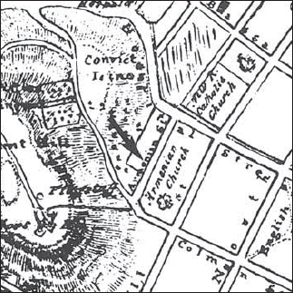
Armenian Street got its name from the Armenian Church (1835) built in the area as seen in this 1843 Thomson map.
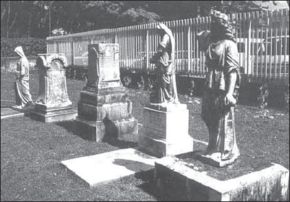
In the late 1960s when the Fort Canning Christian Cemetery was cleared for a park, Levon Palian, an Armenian in Singapore, transported all the Armenian tombstones to the church grounds. Other tombstones were also brought in from the Bukit Timah-Cavanagh Road cemetery. The Armenian Church was gazetted as a national monument on 28 June 1973. The tombstone of Agnes (Ashgen) Joaquim is located in the church compound. Ms Joaquim created the first orchid hybrid in Singapore, known as the Vanda Miss Joaquim Orchid, which was named Singapore’s national flower in 1981. The Armenian community today remains small with about a dozen families acknowledging their ancestry to early Armenian immigrants in Singapore: Aviet, Carapiet, Galestin, Galistan, Johannes, Moses, Sarkies and Zechariah.
Armenian Street
Many of the Armenian Pioneers in Singapore have their gravestones in the grounds of the Armenian Church as in this picture on the right.
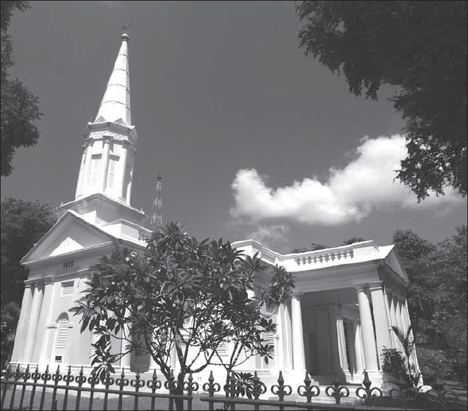
Today, the Armenian Church has been gazetted as a national monument and restored to its original glory.
A landmark on this street is the 86-year old Tao Nan School, set up by the Hokkien community in 1906, and built between 1910 and 1912. The school was converted into a museum showcasing Asian artefacts in 1997 and later became the Peranakan (Straits-born Chinese or Nyonya Babas) Museum, the only one of its kind in the region.
SOURCE: Song, 1984:131-32; Edwards & Keys, 1988:365-66; The Sunday Times, 10 July 1988; The Straits Times, 2 Mar 1998; Wright, 2003:45, 63-64, 147; Preservation of Monuments Board, 2009: 107
This road was named after Simon Aroozoo (1849-1931), who lived at Number 74 Waterloo Street and worked with Guthrie & Company for 50 years (1865-1915). Simon Aroozoo was of Malaccan-Portuguese origins, the son of Joaquim Araujo and Pauline de Santa Maria. He was a colleague of Gan Eng Seng at Guthrie and Company. He is said to have either bought the land or was given the land around Aroozoo Avenue by Gan Eng Seng and continued to monitor and administer the plantation of Gan Eng Seng after his death in 1899 till 1912. The total estate of Gan Eng Seng was valued at $2 million before it was redistributed. Aroozoo Avenue/Lane and Simon Road/Walk/Place are all named after Simon Aroozoo.
SOURCE: Braga-Blake and Oehlers, 1992:94; Dabbs, undated
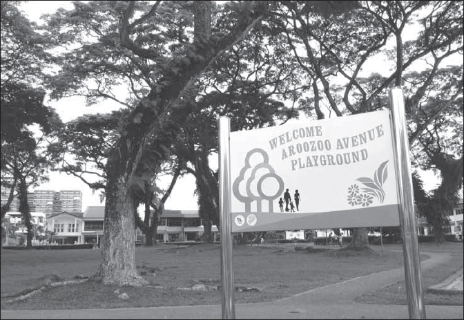
Aroozoo Avenue
The land around Aroozoo Avenue has been developed into landed housing.
This road is named after the 1st Singapore Regiment of the Royal Artillery (1st SRRA) based on the island of Blakang Mati (now Sentosa). The Regiment was tied partly to Fort Siloso which still stands in Sentosa.
The name Arthur Road was originally given to a road stretching from Grove Road (expunged) to Meyer Road in 1921, “with the view of simplifying the house numbering of the town”. It was named after Sir Arthur Henderson Young, Governor of the Straits Settlements (1911-20).
SOURCE: ARSM ASD, 1921:3A; Ramachandran, 1969:2
This area was formerly part of the British military base. This road forms part of Sussex Estate. All the road names, including Arundel, Goodwood and Horsham Roads, are named after places in Sussex County.
SOURCE: Edwards & Keys, 1988: 310
This road was named after Mr Asimont, a land valuer and broker who lived and owned property in this area.
SOURCE: Raja-Singam, 1939:81
It was the old Supreme Court. It was reconstructed as Assembly House and opened on 7 July 1954. The building dates back to 1827.
See Admiralty Road
See Akyab Road
This road is named after a Burmese river town. Many of the roads around Balestier Road carry names after Burmese places. The idea came from an old and respected Burmese resident who suggested it to the Municipality, which accepted the idea.
SOURCE: Raja-Singam, 1939:81; Ramachandran, 1969
Together with Cranborne Road, Lyndhurst Road and Wimborne Road, this was one of the roads named in 1939 after small towns in south England.
Ayer Rajah in Malay literally means the “raja’s water” or “king’s water”. However, there is no historical evidence of a stream here or of a Malay royal settlement in this area. The closest area of nobility is at Telok Blangah where the Temengong and his followers lived (now the Sultan of Johor’s mosque).