This road is named after the cable ship, Cable.
SOURCE: Raja-Singam, 1939:89
These street-names took their inspiration from Charles Carnie’s (1810-73) first house, called “Cairn Hill”, built in 1840 and located on a hill in the Tanglin area, or the man himself. In 1848, Charles Carnie had 4,370 nutmeg trees on his plantation. A painting of the house was made by Thomson in 1849. Charles Carnie married Frances Amelia Bernard (1823-91) who was the daughter of Esther Farquhar (1796-1838), Farquhar’s first daughter. Charles and Frances Amelia Carnie had 17 children and more than 40 grand-children. The Carnie branch of William Farquhar’s family tree now counts 145 and the global Farquhar tree over 780 members.
The Al-Falah Mosque, at the junction of Cairnhill and Bideford Roads, which was opened in January 1987, is the first mosque in a high-rise building and accommodates 1,500 people.
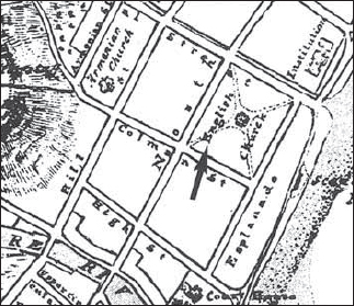
Cairnhill Road
Cairnhill House after which Cairnhill Road was named. The house, built in 1840, was the residence of Charles Carnie.
SOURCE: Gibson-Hill, 1954:200; Moore, 1969:209a; Edwards & Keys, 1988:245; Ramachandran, 1969:18; The Straits Times, 13 Jan 1987:12; Fuchs, 2012, personal communication
See Covent Garden
Originally known as Cheang Jim Hean Street, this street was renamed in 1914.
See Andrew Road; Olive Road
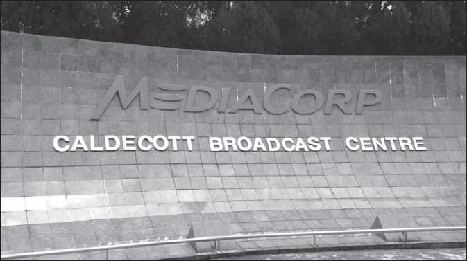
This hill is named after Sir Andrew Caldecott, a distinguished and highly regarded colonial administrator. He served as acting Governor of the Straits Settlements and Colonial Secretary in the 1930s, and was later Governor of Hong Kong as well as Governor of Ceylon. The houses on Caldecott Hill estate were built by Fogden Brisbane and Company and were the properties of the late Mr N. Mistri of Phoenix Aerated Water Company Limited. Andrew and Olive Roads in this area are named after Sir Andrew and his wife, Lady Olive. Caldecott Hill is now the home of MediaCorp Singapore.
SOURCE: Raja-Singam, 1939:89; Ramachandran, 1969:25
Caldecott Hill
MediaCorp Caldecott Broadcast Centre is the best known landmark on Caldecott Hill.
Part of Caldwell’s house forms the major front facade of CHIJMES (left side of the Gothic Church). The house was built in 1840 by George Coleman and was commissioned by H.C. Caldwell, the Senior Sworn Clerk to the Magistrates. It was one of the last buildings that Coleman completed. Caldwell’s house is one of only two houses dating back to the 1840s/1850s that remain in the colonial district – the other being the old Parliament house that was built for the trader, John Maxwell by G.D. Coleman in 1826-1827.
In 1854, a group of Sisters from the Holy Infant Jesus Order (also known as Les Dames de St Maur) set up home in Caldwell’s House and opened a school within a short span of two weeks. By 1892, the Convent had 360 pupils, 200 orphans, 30 poor women, 26 babies, and over 40 Sisters. The Convent also became an orphanage with babies abandoned at the door steps of Foundlings’ Gate (now preserved as the “Gate of Hope”). In 1983, the Town Convent (CHIJ) finally closed and shifted to Toa Payoh.
Henry Charles Caldwell held several government positions as sworn clerk (1836-39), senior sworn clerk (1839-55) and registrar (1855-56). He left Singapore in 1856 because of financial difficulties.
SOURCE: Lim, 2008
This road is located in Tanglin Barracks and probably got its name because it referred to the British military camp located here.
SOURCE: Thompson, 2012, personal communication
This lane is named after Robert Campbell, managing partner of Martin Dyce & Company in the 1870s.
SOURCE: Raja-Singam, 1939:90
See Angsana Avenue
Camphor Avenue is one of several roads in an area developed in the early 1950s as part of Sennett Estate, a middle-income housing estate. The name was chosen by C.W.A. Sennett, the developer, in order to approximate a Malayan theme, which he believed would be acceptable to the local population (although not all names chosen were strictly Malayan). The name was approved by the Municipal Commissioners in 1951.
SOURCE: MPMCOM, 14 Sep 1951
See Admiralty Road
See Admiralty Road
This road was probably named after the Australian capital Canberra as many of the roads in the Naval Base were taken from cities and countries in the British Commonwealth. Canberra House (named after the road) was probably changed in the 1960s to Admiralty House, which is located in the area as part of the former British naval base. The house was the residence of the Rear Admiral of the British Navy.
These roads are named after Charles John Canning known as ‘The Viscount Canning’ (1812-62), who was Governor General of India from 1856 to 1862 and during the Indian Rebellion in 1857.
Cannery Lane was originally named after one of Singapore’s very early wealthy merchants, Chong Long, with the later name change likely linked to the pineapple canning factories in the area in the late nineteenth and early twentieth century.
SOURCE: Samuel, 1991:97
See Alexandra Park
This road is within Alexandra Park, a colonial residential park erected between 1935 and 1940 to accommodate British naval and military personnel. Like other roads in the estate named after English or Commonwealth place names, this road is named after an English town.
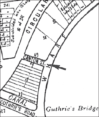
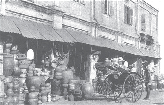
Canton Street
Canton Street was an early street name captured in this 1854 map of Singapore.
This street was not named after a concentration of Cantonese, as there was never such a community in this area. Instead, it owes its name to the port of Canton, the point of departure for early Chinese immigrants to Southeast Asia. Upon arrival in Singapore, they disembarked at the jetty which extended from a street in Boat Quay. This street was subsequently named Canton Street.
It is known as khai ki hue koi a in Hokkien, meaning “small cross street by Boat Quay”.
SOURCE: Firmstone, 1905:72-3
This was the site assigned by Stamford Raffles in 1819 in his directions to Major William Farquhar for barracks for the East India Company’s Sepoy troops. Cantonment refers to a group of lodgings assigned to troops, hence the name of the road. British troops were “cantoned” here between 1824 and 1858. Prior to 1853, Outram Road was also part of Cantonment Road. The Chinese refer to the road as ba suo wei or pa so bue, meaning “end of Bukit Pasoh”.
Raffles intended this area for hospitals, magazines, barracks of the army, houses for civil and military offices of the East India Company, as well as godowns and offices of government. In 1922, however, Raffles found that his vision for the Cantonment Plain was violated. The space reserved exclusively for public purposes was occupied by European merchants in masonry buildings.
A landmark in Cantonment Road is the Sri Manmatha Karunya Eswarar Temple, located near the Tanjong Pagar Railway Station, which had its origins in the 1940s as a modest wooden shed-like structure set up to serve the large Hindu community working in and living near the shipyards. It was rebuilt in 1987.
SOURCE: Raja-Singam, 1939:90; Ramachandran, 1969:41; Firmstone, 1905:70-71; The Straits Times, 5 Nov 1992; Pearson, 1953:47
See Bristol Road
See Opera Estate
This is one of several roads in Opera Estate that drew inspiration from western operas. Others include Aida, Tosca, Swan Lake and Fidelio Streets.
This road was named after A.T. Carmichael of the Chartered Bank in the late 1860s.
SOURCE: Raja-Singam, 1939:90
This street got its name because, in the early days, many Chinese tukangs or carpenters lived and worked here. The Chinese, however, used to call the street Ghee Kok Street because the powerful Ghee Kok secret society had its meeting place here. Up to 1979, there were 382 vegetable wholesalers in the Carpenter Street as well as the Tew Chew Street and Chin Hin Street areas. They were moved to the Pasir Panjang Wholesale Market in February 1984.
This street is also known as hi kuan koi in Hokkien, meaning “theatre street”. The first Teochew theatre was in this street.
SOURCE: Braddell, 1921:279; Firmstone, 1905:72-3
Formerly known as Lorong 202 East Coast, this road was named in 1934 after H. Carpmael, the well-known Municipal Assessor.
SOURCE: ARSM AED, 1934:3A
This street is named after a well-known lawyer, R. Carver, who was a partner in the legal firm of Donaldson and Burkinshaw.
SOURCE: Raja-Singam, 1939:90
This street was officially named in 1898. Caseen was originally spelt Kasseen.
SOURCE: ARSM, 1898:14
This street is named after E. Cashin, a lawyer’s clerk to J.A. Solicitor in the 1880s. He invested in opium farms and landed properties and became the first Eurasian millionaire in Singapore. The street is known as hok im kuan au hue hang in Hokkien, meaning “the cross street behind the gospel house”.
SOURCE: Braga-Blake and Oehlers, 1992:94; Firmstone, 1905:72-73
This was the name given to one of the roads within the Singapore Improvement Trust estate at Guillemard Road in 1955, along with Pine Lane and Pine Close.
SOURCE: MPCCOM, 28 Feb 1955
Before the Causeway was completed in 1923, train passengers and the public would board the ferries at Woodlands to cross the strait to get to Johor Bahru. The passengers would then board the waiting train at Johor Bahru. The foundation stone for the Causeway was laid in 1919 and the Causeway was completed four years later. The first goods train from Singapore travelled across on 17 September 1923. The first passenger train from Kuala Lumpur crossed into Singapore on 1 October 1923, from which date the 3,465-foot long Causeway was opened to traffic from both sides. The official ceremonial opening by the Governor, Sir L.N. Guillemard, took place on 28 June 1924 in the presence of the former Sultan of Johor, Sir Ibrahim. On the railing wall to the left and midway are inscribed the initials SJ, marking the Singapore and Johor sides of the Causeway.
The original plans were to have a 60 foot width and 46 foot depth at low tide, costing $17 million, borne by the Federated Malay States and Straits Settlements governments. The granite came from Pulau Ubin and Bukit Timah. The contractors were Topham, Jones & Railton of London. The Causeway is the only one in this part of the world. It was blown up in 1942 to slow down the Japanese advance. Repairs were done after the war. The roadway was widened to 25 feet in 1965. Two water mains run parallel with the rail track, conveying water from the Tebrau and Scudai rivers in Johor to Singapore.
SOURCE: Ramachandran, 1969:68
This road was named after the 10th Earl of Cavan, Frederick Rudolph Lambart (1865–1946), who had absolutely nothing to do with Singapore and, apart from inheriting an Irish peerage, had very little to do with Ireland either. He was a Field Marshall in the First World War and has a street named after him in an area that commemorates well-known generals from the war, such as Foch.
SOURCE: Lim, 2008:31
Originally New Cemetery Road, this road was renamed after General Sir Orfeur Cavenagh, the last Governor (1859-67) of the Straits Settlements to hold office under the Indian Administration. The Hokkiens used to refer to this road as tua ong sua au koi, meaning “the street at the back of Governor’s Hill”, which was probably a reference to the Istana, the home of the British Governor of the Straits Settlements. It is not thought that there is any fixed name for Cavenagh Road.
Cavenagh Bridge is the second bridge from the mouth of the Singapore River linking Empress Place with Fullerton Square. It was proposed in 1867 and opened in 1869. Sir Harry Ord, the Governor at the time of the construction of the bridge, wanted to name it Edinburgh Bridge after the Duke of Edinburgh’s visit to Singapore, but this did not materialise. Instead, the Singapore Councillors decided it should honour and perpetuate the name of the last Governor appointed to Singapore by the East India Company, Colonel (later Sir) Orfeur Cavanagh (1859-67), marking the end of an era. The bridge, built to commemorate the founding of the Crown Colony of the Straits Settlements in 1867, also marked the beginning of a new era for Singapore, which had just become one of the Straits Settlements under the Queen’s first London appointed Governor, Colonel Sir Harry Ord.
Cavenagh Bridge
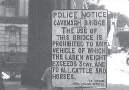
Picture of the police notice that limits the weight of vehicles crossing the bridge.
Cavenagh Bridge
The bridge has been pedestrainised and connects Boat Quay with Empress Place.
Made of steel shipped out from Glasgow by P. & W. MacLellan – the same engineering company that fabricated the steel used to build the Telok Ayer Market – the bridge replaced the ferry crossing. It also ended public discontent at the time over having to cross the river by ferry to go to the Post Office or Master Attendant’s Office (then situated on the river bank near Empress Place), costing a duit (equal to a quarter cent) on each occasion.
Before the building of Anderson Bridge in 1909, Cavenagh Bridge carried tram traffic. It linked Commercial Square (now Raffles Place) with the government administrative quarter and was the last major work of the Indian convicts who built the Istana and St Andrew’s Cathedral. After Anderson Bridge was opened, Cavenagh Bridge became essentially a pedestrian bridge. A sign still stands there today stating that the bridge is closed to “any vehicle of which the laden weight exceeds 3 cwt, and to all cattle and horses”. Today, it still provides a pedestrian linkage between the city and Empress Place and is the oldest surviving bridge across the Singapore River.
Cavenagh Bridge is known as hai ki thih tiau kio in Hokkien, meaning “iron suspension bridge by the sea shore”.
SOURCE: Buckley, 1984:783; Edwards & Keys, 1988:492; Ramachandran, 1969:19; Tyers, 1976:24; Firmstone, 1905:72-3, 142-43
Cecil Street is named after Sir Cecil Clementi Smith, Governor of the Straits Settlements from 1887 to 1893. The road was built on reclaimed land carried out under the Telok Ayer Reclamation project between 1879 to 1888.
SOURCE: Edwards & Keys, 1988:450
See Angsana Avenue
Cedar Avenue is one of several roads in an area developed in the early 1950s as part of Sennett Estate, a middle-income housing estate. It was chosen by C.W.A. Sennett, the developer, in order to approximate a Malayan theme which he believed would be acceptable to the local population (although not all names chosen were strictly Malayan). The name was approved by the Municipal Commissioners in 1951.
SOURCE: MPMCOM, 14 Sep 1951
See Hospital Drive
This is the name of the island between Hospital Drive and First Hospital Avenue.
SOURCE: MPMCOM, 18 Aug 1958
Ceylon Road is named after the large Ceylonese Tamil community that lived around the area. The best testimony of the community’s residence in this area is the site of the Sri Sempaga Vinayagar Temple in Ceylon Road. The temple dates to the 1850s when a stone statue of Lord Vinayagar was washed up on the banks near Sempaga (Chempaka tree) in the area. Ethirnayagam Pillai one of the early Ceylon pioneers built an attap shed under the tree where the statue was installed in a shrine. In 1913, 300 Ceylon Tamil families bought some land in the area and built a larger attap shed to house the shrine. A priest was hired to also conduct daily prayers. The temple has gone through several renovations over the decades, the last renovation being completed between 2000-03. The fifth consecration ceremony of the temple was performed in February 2003.
SOURCE: The Straits Times, 7 February 2003:L6-L7
See Read Bridge; Cuming Street
There are two interpretations for this local place name that formed part of the former Hong Lim Quay area, not far from the Ellenborough market, around the Read Bridge area. The more popular view of this place name developed because of the firewood trade that was centered in the area. Essentially, shops stored their firewood along the road side. Boats from Indonesia traded firewood here and hence the Chinese name.
The second interpretation which is probably more accurate is that the area was a major transporting terminal for the various Chinese river boats. This was the furthest point for ordinary river boats to dock along the Singapore River. Beyond this point, there were godowns but they were owned by various Singaporean and foreign companies. The word cha chun refers to “wooden boats and tau refers to “terminal” or “river point”.
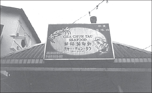
Cha Chun Tao
Picture of a seafood hawker stall at Clark Quay bearing the name ‘Cha Chun Tao’. Photo: V.R. Savage.
The current area, appropriately, was marked by a hawker stall at Clarke Quay called Cha Chun Tau. This hawker stall was actually situated on the opposite river side of the former place, Cha Chun Tau.
There were two Teochew opera theatres near Cha Chun Tau known as Ee Hng (at Merchant Road) and Diat Hng (which was built in 1921 at New Market Street).
SOURCE: Oral History Department, 1990:32
Formerly off Outram Road just before its junction with Havelock Road, leading to the newly-constructed police barracks, this road was named after Captain A.R. Chancellor in 1928. Chancellor joined the Straits Settlements Police as an Assistant Superintendent and later became the Inspector General of Police. He was the first Inspector General of Police to be appointed to the Legislative Council.
SOURCE: MPMCOM, 4 Sep 1928; Raja-Singam, 1939:90; Lee, 1989:134
These roads are named after the well-known street in London near the Law Courts.
Chancery Lane is known as sang chiau in Hokkien, meaning “two birds”, referring to the eagles on the gateway of the drive leading to Mohamed Alsagoff’s house at the Thomson Road end of Chancery Lane.
SOURCE: Firmstone, 1905:150-53
This road was named after the Indian Municipal Commissioner, A.C. Chander.
One of the roads in the Alexandra Industrial Area off Leng Kee Road, this road name was officially assigned in 1957.
SOURCE: LO 1362/47, 25 Nov 1947: Renumbering and naming of roads in the City Area (enclosure dated 11 Nov 1957)
Linking Raffles Place to Collyer Quay is a small lane named after the Change Alley of London, where stockbrokers congregated. This small lane of shops and hawkers, selling everything from clothes to curios and toys to household necessities, was for decades the busiest shopping area in the city. Before acquiring its present name in the late nineteenth century, it was known as Spottiswoode Lane. The old Change Alley came to an end in 1984 when it was demolished.
Change Alley is a bazaar passageway of central Singapore. The shopkeepers belong to an association called the Change Alley Merchants Association. Their members conduct business in various languages using broken French, English, Italian and Russian – derived from years of dealing with seamen and tourists from all over the world. The street’s name is also thought to derive from the money changers who frequented this area in the days when visitors and seafarers arrived at the waterfront and made their way to Raffles Place through the alley. In its heyday, Change Alley was a tourist attraction for shopping. Shopkeepers and hawkers of all nationalities sold their wares and goods here. One of the celebrated hawkers was the Jewish hawker Solomon, known as the “lima satu sen” because he shouted out sales of his camphor balls, five for one cent. The signature shop in Change Alley after the Second World War was “Albert Store”, which was opened in 1948 by Albert Lelah (1913-97). He was the Vice-President of the Change Alley Merchants Association for 15 years and the only shopkeeper in the Alley to receive the prestigious Certificate of Cooperation from the Singapore Tourist Promotion Board.
The current Change Alley (Change Alley Aerial Plaza) now extends as an aerial shopping walkway that is found on the overhead bridge connecting the Clifford Pier area with the Arcade.
SOURCE: MPMCOM, 26 Jan 1891; Tyers, 1976:246; Bieder, 2007:169
Changi Point
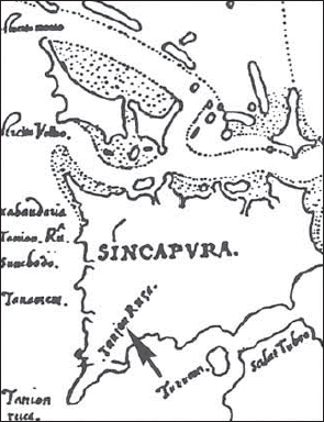
The early reference to Changi in this 1604 Godinho de Eredia map was Tanjon Rusa or Tamion Ruca.
The early Malay place name to Changi was Tanjong Rusa which is found in the 1604 E.G. de Eredia map of Singapore.
The native place name Changi is found very early in Singapore’s history. In the 1828 map by Franklin and Jackson, the extreme south eastern tip of the island is referred to as Tanjong Changi. The local name Changi must have been a significant point for the Malay world, especially in the days of the sixteenth century Johor kingdom located on the Johor River. Vessels using the Johor Straits would have to pass Changi.

Changi
This 1828 map of Singapore by Franklin and Jackson clearly shows that ‘Changi’ (Tg Changi) was an early place name. It was also referred to as Franklin Point after Captain Franklin who surveyed Singapore island.
Changi Road
Present day street sign of Changi Road reflects its cultural heritage. Photo by National Library Board. All Rights Reserved. National Library Board, Singapore 2013.
There are various versions of the etymological roots of the name Changi. One source says that it comes from a climbing shrub, the changi ular (apama corymbosa), which grew in the area. Another claims that it gets its name from a tall tree, the dhengai (balanscarpus heimii), which abounded in the area in the early nineteenth century. Changi could also be a variation of the local timber named chengai. This heavy local timber is commonly used for buildings and furniture and is valued for its strength and renowned for its deep rich colour.
Changi is also said to have derived its name from the Hopea Sangal tree which is popularly known as the Chengal Pasir or Chengal Mata Kuching. One specimen of this tree, that was thought to be extinct, was found to be growing in the Changi area but was mysteriously felled in 2002.
During the early surveys (1820s-30s) of Singapore Island, Changi was also named Franklin Point after Captain Franklin who was involved as one of the early surveyors of Singapore Island. It would seem that the colonial authorities had decided to latch on their own place name to the existing Malay name for Changi.
Around 1901, Changi was the haunt of tigers; the females were said to swim over from Johor to Pulau Ubin to take a breather and complete the journey to Singapore, landing at Fairy Point and giving birth in the neighbourhood. The tigers on the island were hence generally young.
Changi is also well-known for Changi Prison, completed a few years before World War II and an internment place for British and Australian POWs, including civilians, during the Japanese Occupation.
SOURCE: Ramachandran, 1969; Raja-Singam, 1939:90; Wee and Corlett, 1986:15; Brown, 1936:18; The Straits Times, 23 November, 2002:3
Chatsworth Road is named after a house owned by George Gorden Nicol, located on top of the hill near Oxley estate. The grounds contained a nutmeg plantation. The name was obviously borrowed from that of the Duke of Devonshire’s country house in Derbyshire, England. By 1848, Chatsworth was the largest nutmeg estate, covering 60-odd ha over six hills and consisting of 8,000 trees. In 1859, Chatsworth House was offered for sale.
In 1929, when a private road off Chatsworth Road came up for naming, one of the Municipal Commissioners, E.A. Brown, suggested using road names associated with the Duke’s country house, such as Rowsley Road, Bakewell Road, Haddon Road and Edensor Road. The suggestion was turned down by the Municipal President, R.J. Farrer, who favoured “simple names where possible”, as “Singapore was not England” and “the generality of persons [in Singapore] [found] names like Rowsley difficult”. The road was eventually named Davie Road, but this was changed to Chatsworth Park two years later.
SOURCE: SIT 876/29, 19 Mar 1929: Private road running from Bishopsgate to be named “Chatsworth Park”; Edwards & Keys, 1988:193
See Teck Guan Street
Located within Tiong Bahru, the first Singapore Improvement Trust estate built in the late 1930s, this street was named in 1941 on completion of the housing estate after the Malacca-born Chinese estate owner, Tan Chay Yan (d.1916), eldest son of Tan Teck Guan. Chay Yan was the first Chinese to plant rubber on a commercial basis (Bukit Asahan Estates) in Malaya in 1896. He lived in Malacca but made frequent trips to Singapore. He was a Justice of Peace, a Municipal Commissioner and an office bearer of the Kuomintang in Singapore.
SOURCE: MMCI, 31 Mar 1941; Song, 1984:293-4
See Hong Lim Green/Park
Formerly referred to as Cheang Hong Lim Street, this street is named after the wealthy Chinese opium and spirit farmer, Cheang Hong Lim (1841-93). He was buried in Bukit Brown Cemetery. He was a large property owner in the Havelock Road area and erected the Geok Hong Tian, a Chinese temple, in Havelock Road. He also maintained his own fire brigade in 1886 to protect the area, as well as a private market, the Hong Lim Market. In 1876, Hong Lim converted an open space into a public garden known as Hong Lim Green. The Hokkien Chinese used to refer to this street as peh keng a, “eight small buildings”, which indicates the modest size of this street.
SOURCE: Song, 1984: 168-69; Firmstone, 1905:74-75; Goh, 2011, personal communication
See Cheang Hong Lim Street
This street is named after Cheang Jim Chwan, the son of Cheang Hong Lim. He is buried in Bukit Brown Cemetery.
See Cheang Hong Lim Street
This street is named after the Chop Wan Seng, the firm of Cheang Hong Lim, a wealthy spirit and opium merchant. Hong Lim also opened a school here, called the Cheang Wan Seng School, which admitted, free of charge, students of all creeds and races.
This road is known as chiu long pi to the Hokkiens, meaning “beside the spirit depot”.
SOURCE: Song, 1984:168, 178; Firmstone, 1905:74-75
This road, which was taken over as a public street in 1951, was so-named at the request of the owners of the land on which the road was built. The owners belonged to the surname Oei and Chee Hoon was the name of their clan.
SOURCE: MPMCOM, 4 May 1951
See Angsana Avenue
Chempaka Avenue, named after a local flower, is one of several roads in an area developed in the early 1950s as part of Sennett Estate, a middle-income housing estate. It was chosen by C.W.A. Sennett, the developer, in order to approximate a Malayan theme which he believed would be acceptable to the local population. The name was approved by the Municipal Commissioners in 1951.
SOURCE: MPMCOM, 14 Sep 1951
This used to be a curved street with both ends joined to Tanjong Pagar Road, where Tanjong Pagar Plaza is now located. It is believed to be named after Khoo Cheng Cheok, brother of a rice merchant named Khoo Cheng Tiong, one-time president of the Thong Chai Medical Institute.
The Hokkiens refer to this street as gu kak hang, meaning “ox horn lane”. It is so-called because the street runs more or less in a semi circle, from Tanjong Pagar Road back again to Tanjong Pagar Road, forming a crescent or a pair of ox horns.
SOURCE: Lee, 1989:133; Firmstone, 1905:74-7
The roads in this vicinity are named after Wee Cheng Soon, a property owner in the early twentieth century.
Once a cul-de-sac off Tanjong Pagar next to Cheng Cheok Street (also expunged), this street was named after the Singapore-born Chinese trader and ship chandler, Tan Cheng Tuan (1864-1902), son of Tan Kim Swee. His firm operated under the style of Seng Teck Bee and he was also a director of the China Mutual Life Insurance Company. Cheng Tuan was an elected Municipal Commissioner for Central Ward between 1898 and 1900. He owned land in Tanjong Pagar, and built six shophouses along Tanjong Pagar Road.
SOURCE: Song, 1984:316-18
See Choon Guan Street
This street was named in 1906 after the Malacca-born businessman Lee Cheng Yan (b.1841), who started Chop Chin Joo in 1858 as a firm of commission agents and general traders. The firm became one of the largest Chinese businesses dealing with Europeans. Cheng Yan served on several boards and was a Justice of Peace. He founded the Hong Joo Chinese Free School (Serangoon Road), was one of the original trustees of the Gan Eng Seng Free School and was on the board of several other schools. He built “Magenta Cottage” at the corner of River Valley and Killiney Roads around the 1870s. His Amber Road was “Mandalay Villa”. Cheng Yan was the father of another prominent Straits-Chinese, Lee Choon Guan.
SOURCE: MPMCOM, 12 Jan 1906; Song, 1984:110-11
See Chin Nam Street
This road is named after Cheong Chin Nam, the son of Cheong Chun Tin, the first qualified Chinese dentist in Singapore. Besides being a qualified dentist, Chin Nam was also a merchant, landowner, and rubber plantation owner. The two brothers, Chin Heng and Chin Nam, ran the Cheong Brothers dental practice.
This road is named after the Hainanese businessman, Wee Cheow Keng. He was a leader of the Hainanese community and director of the Sze Hai Tong Bank.
SOURCE: Song, 1984:546-7
The road behind the old Hume Factory is named after the wealthy towkay Chia Eng Say, and led to his granite quarry, together with the kampong and the workers quarters. The current road in front of the Rail Mall in Bukit Timah is called Chia Eng Say Road. Eng Say was an immigrant from China who was penniless but became very rich in Penang and Singapore, where he was resident. He made his wealth in Penang in rubber, tin, trading, as a contractor and in quarrying. He had a huge rubber estate in Johor. He was shot in the back during the Japanese Occupation for breaking the night curfew. He made legal history after World War II when his 12 wives contested his large estate. The court ruled that his first six wives were legal and the second six wives were illegal wives. He had 7 sons and 15 daughters.
SOURCE: Basapa, 2012, personal communication; Low, 2012 personal communication
Chia Ping means “superior quality goods” in Mandarin. Like other roads in the Jurong Industrial Estate area, street names were sometimes chosen to reflect the quality and nature of industrial activities.
In 1854, the Convent of the Holy Infant Jesus (CHIJ) opened on Victoria Street though the oldest building was H.C. Caldwell’s house (1841) which was next to the Convent. It remained in Caldwell’s hands until August 1852. The house was purchased by Father J.M. Beurel for the convent. The French Gothic chapel dates from 1909. The home for abandoned babies closed in 1982. In December 1983, the school left its Victoria Street premises and moved to Toa Payoh. In 2005, the school celebrated its 150th anniversary. Like Raffles City, CHIJMES is now another commercial complex in the heart of the colonial district that is named after the school that was located here. It has been redeveloped into a restaurant/shopping complex that retained many of the old buildings in the school (Caldwell House, the Anglo French Gothic Chapel and the Gothic corridors leading to the chapel).
SOURCE: Kong, Low & Yip, 1994; The Straits Times, 13 April 1987:17; Hancock, 1986:54
Formerly known as Lorong 207 East Coast, this road was officially renamed in 1934 after a local fruit. Several other streets in the area are also named after Malayan fruits, including Duku Road, Langsat Road, Lorong Nangka, Pulasan Road, Rambai Road and Rambutan Road.
SOURCE: ARSM AED, 1934:3A
Chin Bee Avenue, Drive, Road and subsidiary roads Second, Third and Fourth Chin Bee Road were officially named in 1971.
SOURCE: IRD 16 Nov 1971, MC 70, VII
See also Upper Chin Chew Street
In the 1820s, like Cross Street, this street was an Indian residential area, the site of the Chulia compound. The Tamils used to call it Arampillei’s Road. Later the Chinese dominated the area. The street was known to the Chinese as tau fu kai or “beancurd street”, because of the many beancurd cottage industries and sellers located here. The Hokkiens would refer to it as tau hu koi, which also meant “beancurd street”. Later the area became a locus for samsui women (Chinese construction workers), and was called “black cloth street”.
SOURCE: Archives & Oral History, 1983:48, 57-58
Chin Chew Street
A 1950s view of Chin Chew Street showing street hawkers.
This street was named after the well-known Chinese merchant, Lim Chin Hin. A keen volunteer, he was also well-known for his shooting skills. This area was also dominated by Teochew residents, hence its other name, “Teochew new street”, or chao zhou xin jie. It has also been suggested that the name was derived from Teochew gambier merchant Seah Eu Chin’s shop, Chop Chin Hin, which was in the vicinity.
The street is known as tua poh sim koi a in Hokkien, meaning “big town new little street”. “Big town” is distinguished from “small town”, which is across the Stamford Road canal. It was necessary to add the “big town” here because there is another “new street” – Fraser Street – in “small town”. The Hokkiens also refer to Chin Hin Street as sin pa sat sin koi, meaning “new market new street”. “New market” refers to the nearby Ellenborough Market.
Up to 1979, there were 382 vegetable wholesalers in the Tew Chew Street, Chin Hin Street and Carpenter Street areas. By February 1984, all the vegetable wholesalers had been removed to the Pasir Panjang Wholesale Market. It was common to see people carrying away large rattan baskets filled with green vegetables along this street in the mornings.
SOURCE: Firmstone, 1905:76-77; Oral History Dept., 1986b:47; Chiang, 1985:14
See Chun Tin Road
In 1905, this new street was opened by and named after Cheong Chin Nam, a well-known dentist as well as a merchant, landowner and rubber estate owner. In partnership with his brother Chin Heng, Chin Nam owned a dental practice (Cheong Brothers). Chin Nam was the son of Cheong Chun Tin, the first qualified Chinese dentist to settle in Singapore.
The colloquial name for Chin Nam Street together with High Street, Hill Street, Hock Lam Street and North Bridge Road near the Singapore River was shui xian men.
SOURCE: MPMCOM, 27 Jan 1905; Song, 1984:157
This road was named after the wealthy Hokkien businessman, Lim Chin Swee, son of Lim Eng Keng, who owned a thriving business in the 1870s.
The Hokkiens refer to this road as siok ui sua teng, which means “Siok Wee’s plantation”. The land here belonged to Kiong Siok Wee.
SOURCE: Raja-Singam, 1939:92; Firmstone, 1905:78-79
This was a notorious street in the past because of the many gambling dens located here. It was known in Hokkien as kiau keng khau, or “gamblers’ corner”. Another Chinese name for this street in the past was Ghee Hin Street, after the powerful secret society which had its meeting place here.
The Hokkiens refer to this street as kiau keng khau, meaning “gambling houses mouth” i.e., the street on to which the gambling houses open, and as gi hin kong si, meaning “Gi Hin kongsi house”. There was formerly a kongsi (reference to a Chinese organisation meeting house) house of the old Gi Hin Society here.
In the minutes of the March 1858 Municipal Council meeting, it was stated that “There being two Cross Streets and two China Streets, those to the north of the river should henceforth be called Little Cross Street and Hylam Street.”
SOURCE: Braddell, 1921:279; Firmstone, 1905:76-7, MPMCOM, 30 Mar 1858
See also Kreta Ayer; Smith Street
In 1822, Raffles, noting the industry, resourcefulness and capacity of the Chinese for expansion, issued instructions that the south western part of town be set apart for their habitation. That part is Chinatown, developed into tua poh (the big place) around the South Bridge Road area. Chinatown covers roughly a triangle, having for its base Telok Ayer Street from Anson Circus to the Singapore River; for its right side, the river bank up to the source near Tan Kim Seng’s Bridge; and for its left side, Anson Circus to Outram Road. Both sides meet at the apex, the Havelock Road area. Several bridges span the river to link Chinatown with a district.
In the Singaporean context and for most Chinese in the region, the Cantonese and Hokkien names for Kreta Ayer are often used to refer to Chinatown: gu chia chui (Hokkien) or ngow chay shui (Cantonese). Both gu chia chui and tua poh were already references used in the 1880s. During the nineteenth century, Pagoda Street, Temple Street, Trengganu Street and Smith Street were also places of entertainment in Chinatown. The concentration of entertainment gave Chinatown its colloquial name, but yeh tien or the town that never sleeps. The heart of Chinatown remained a Cantonese domain. In a 1922 economic survey, there were 27 teahouses, eating houses and restaurants owned by Cantonese in Chinatown.
Early Chinatown street names in the 1836 Map of Singapore.
Part of Pagoda Street in Chinatown has been pedestranised. The architecture of the buildings retains elements of Chinese culture.
SOURCE: Ramachandran, 1969:6; Oral History Department, 1990:5-7
Formerly listed as Chetty Road, this road got its named from a chettier who was convicted and thus ostracised by other chettiers. He lived in the swampy Malay kampong of Kampong Kapor, where he reared bullocks and goats. Chitty could also be a reference to the Peranakan Indians, South Indian merchants who have settled in Malacca and Singapore for many centuries and spoke Baba Malay, ate Peranakan food and adopted some local Malay traditions but remained Hindus. The small Chitty community used to be concentrated in Selegie Road, Race Course Road, Chitty Road and Serangoon Road.
SOURCE: Raja-Singam, 1939:92
By the 1840s, the Chinese had established themselves in riverine settlements across the island, particularly in the north. Each village was named after the family clan controlling that part of the river (kang), a practice brought over from China. These names have survived to this day in such districts as Choa Chu Kang (on Sungei Berih), Lim Chu Kang and Yio Chu Kang. Other forgotten villages were Lau Chu Kang on the Sungei Mandai (Sungei River), Tan Chu Kang on the Mandai Kechil, Chu Chu Kang on the Kranji and Chan Chu Kang on the Seletar. The road to Lim and Choa Chu Kang was cut during the time of John Thomson’s tenure as Land Surveyor around 1852-53. The Choa Chu Kang area began as a cluster of farms around Lim Chu Kang, Neo Tiew, Yew Tee and Ama Keng. The original settlers of Choa Chu Kang village were pepper and gambier farmers who were mainly Teochews. They were later joined by pineapple, rubber and coconut planters who were Hokkiens (from the Nam Ann or An Hui provinces), and finally, market gardeners. Pig and poultry farming also predominated. Today, the Choa Chu Kang area contains a New Town as well as a public cemetery for different races and creeds.
One explanation for the name Choa Chu Kang refers to an early settler Mr Chua who built his house (chu) by the side of the Kranji River (kang).
SOURCE: The Straits Times, 9 December 1986:18; Singam, 1957:272; Oral History Department, 1990:50
Off Chin Swee Road, this street was named after a prominent Chinese shipowner and merchant in the 1860s, Choa Lum Tiong.
SOURCE: Raja-Singam, 1939:92
See Nee Soon Road
This road was officially named in 1955 after the eldest son of Lim Nee Soon, Lim Chong Kuo. Chong Kuo was buried at Bukit Brown Cemetery.
SOURCE: The Grassroots Organization of the Nee Soon Community, 1987:42
See Nee Soon Road
Both the road and the village are named after Lim Chong Pang (d.1956), the son of Lim Nee Soon. A leader of the Teochew community, he was a successful racehorse owner and businessman in Singapore and Malaya. Chong Pang was a member of the Rural Board from 1929 to 1938 and as a reward for his services the colonial government named the village after him. Chong Pang Village was razed by bulldozers in March 1989 to make way for Sembawang New Town. Chong Pang’s grave is in Bukit Brown Cemetery.
SOURCE: The Straits Times, 29 May 1987; Ramachandran, 1969:24; Sequerah: 1995:181-201
See Cheng Yan Street
This street was officially named in 1927 after the wealthy Chinese businessman, Lee Choon Guan (b.1868), son of Lee Cheng Yan. Choon Guan served the colony in various official posts: he was a Justice of Peace, a Municipal Commissioner and towards the end of 1918, Chinese member of the Legislative Council. He was also a member of the Chinese Advisory Board and a committee member of Tan Tock Seng Hospital. Choon Guan was the chairman of the Chinese Commercial Bank and director of the Straits Steamship Company, South British Insurance, and several other rubber companies. He gave liberally to war charities during the First World War, as well as educational institutions such as Methodist College and the Raffles College Endowment Fund.
SOURCE: MPMCOM, 30 Sep 1927; Song, 1984:111-12
The name of this road means “bamboo grove” in Chinese.
This street-name means “bamboo garden” in Chinese.
See Choa Chu Kang
Chua Chu Kang was first cut in the 1840s. Chua Chu Kang used to be a Chinese district, located nine miles from town at the junction of Mandai and Thomson roads. It was a large village, with large rubber estates in the vicinity. Chua Chu Kang is a Chinese name. Kang is “river” and chua the seh or clan name of the original headman (kangchu) responsible for the riverine produce. The river referred to is the Sungei Berih and the kangchu settled at its mouth.
SOURCE: Ramachandran, 1969:33; Raja-Singam, 1962:245

Chuan Hoe Avenue
Tombstone located in the Japanese cemetery.
Chuan Hoe Avenue is the site of a Japanese cemetery. It was known by locals living there as ‘Jit Pun Tiong’.
SOURCE: Tan TT, 2012, personal communication
Chulia Street was formerly known as Kling Street because of the concentration of Indians from southern India, who were known as “men from Kalinga” or in Malay, orang kling. Kling Street was one of the early streets of Singapore, developed probably in the early 1820s, and appears in Coleman’s 1836 Map of Singapore. It is the only spatial reference to the presence of this Indian community on the modern landscape. When Indian convicts were transported to Singapore, Kling had a derogatory association and hence the name Kling was dropped and formally replaced on 24 December 1921 with Chulia – a reference no doubt to the Chulias from India who were concentrated in this area (the North Indian term for the Kalinga kingdom is Chulia).
The Chulia Street/Market Street area was the earliest locus for the concentration of Indian workers and professionals, including petty shopkeepers, watchmen, money lenders, bankers and lawyers. There were many Indian Muslim shops in this area, dealing mainly with stationery in the 1950s to the time the shophouses were demolished in 1982-83. Most of the Indian Muslims were Gujeratis who concentrated their businesses on hardware, textiles, spices, stationery and lived in the shophouses above in the Chula, Market and Malacca Streets area.
Originally, Chulia Street was lined entirely by two-storey buildings, and until recently it, together with De Souza and Market Streets, bore little change from its mid-nineteenth century origins. However, the landscape has been dramatically altered since the construction of the OCBC Centre in 1976 and the OUB Building in 1974, at its western and eastern ends respectively.
For over a century until the 1970s, the Teochews at Chulia Street dominated the import, export and wholesaling of such dried seafood products as dried shrimps, salted fish, sharksfin and sea cucumber. At present, most of the leading firms in this trade are concentrated in North Canal Road, mostly in old, pre-war shophouses which are slated for demolition in the process of urban renewal.
SOURCE: van Cuylenburg, 1982:28; Doggett, 1985:125; Edwards & Keys, 1988:451; Oral History Department, 1986b; Ng, 1991:94
Chulia Street
The former name of Chulia Street was Kling Street, a reference to the people who came from Kalinga, India. In the 1960s and 1970s, many Indian Muslim shops were located along this street.
See Chin Nam Street
This road is named after Cheong Chun Tin (d.1898), the first qualified Chinese dentist to settle in Singapore. Born in Hong Kong, Chun Tin qualified as a dental surgeon in the USA before opening a well-patronised dental practice in South Bridge Road. His two sons, Chin Heng and Chin Nam, followed his dental practice and ran the Cheong Brothers dental practice.
SOURCE: Song, 1984:157; National Heritage Board, 2007
This road is named after the Bethesda Church, which is located opposite the lane.
Church Street is an old street of Singapore developed in the 1820s and appears in George Coleman’s 1836 Map of Singapore. The street is named after Thomas Church, a resident councillor from 1837-56. Church bought the Court House (formerly Maxwell’s House and now Parliament House) for 15,600 Spanish dollars. Thomas Church first lived in a house built in 1829-30 at the corner of Coleman Street.
Coleman’s map actually depicts two Church Streets. Apart from the present Church Street, the other, now called Waterloo Street, was so-named after the Roman Catholic Church (St Peters and Paul) located in the area.
The street is known as go tai thien kiong to the Hokkiens, meaning “heavenly palace of the five generations”. Thien kiong (heavenly palace) is an abbreviation for thien hok kiong, i.e., palace of heavenly bliss. There is a temple of this name on this street, in which five joss stick shrines of different se or clan names are enshrined.
SOURCE: Hancock, 1986:25; Firmstone, 1905:78-79
The two roads are named after the Chinese merchant and philanthropist, Lim Chwee Chian (1864-1923), who was also the known leader of the Ngee Heng Kongsi, a Chinese secret society in Singapore. He was made a Justice of Peace in 1918 by the colonial government and a member of the Chinese Advisory Board in 1919. Mr Lim also founded the Ee Hoe Hean Club, one of the oldest millionaires’ social and business clubs. He came to Singapore from China with little education and worked as a bumboat worker. With his savings he established the Swee Hong Seng Company, providing shipping services between Singapore and Malaya. Later he was involved in wolfram mining and became known as the ‘Wolfram King of Malaya’.
In 1922, together with Lim Ho Puah, Lim Peng Siang and Lim Boon Keng, he founded the Ho Hong Bank in 1917 and was a director until his death in 1923. Before his death, however, his company Swee Hong Seng suffered heavy losses when wolfram prices fell dramatically in 1922. When he died, the funeral took place in his residence at Ann Siang Hill before his body was sent back to China for burial. Chwee Chian’s funeral was one of the largest observed in Singapore, with flags flown at half mast in the Chinese Chamber of Commerce, Chinese High School and Ai Tong School.
SOURCE: Wee, Jane, Singapore Infopedia, National Library
See Boat Quay
This is an early road developed in Singapore sometime in the late 1820s and appears in George Coleman’s 1836 Map of Singapore. It was one of the main roads drawn up by Raffles to link South Bridge Road with Market Street and Commercial Square (now Raffles Place). The road was named because it followed the curve of the Singapore River. Located behind Boat Quay, the Hokkien Chinese used to refer to it as chap peh keng au, “behind the eighteen buildings”, or chap sa hang au, “behind the thirteen shops”, where the “buildings” or “shops” in question referred to Boat Quay. It was once the main centre of business for Chinese merchants trading in textiles and straits produce such as shark’s fins, tin, rubber, coffee, tea, dried sea cucumber and spices.
Circular Road
Circular Road is one of the old street names as indicated in this 1836 Map of Singapore.
A big fire swept through the area in 1830, which burnt down Phillip Street, one side of Market Street and part of Circular Road. Subsequently, new terrace houses and shophouses were built by private enterprise in 1831.
An interesting feature to look out for along Circular Road is the oddly shaped corner building at Number 79, with its “fins” and tower. It was designed and built by architect Ho Kwong Yew in 1938.
SOURCE: Raja-Singam, 1939:93; Firmstone, 1905:78-79
Located in Princess Elizabeth Estate off Upper Bukit Timah Road, this road was named in 1952. Other roads named during the same exercise include Elizabeth Drive, Philip Walk, Prince Charles Crescent and Princess Ann Hill.
SOURCE: SIT 1067/51, 25 Oct 1951: Naming and renumbering of roads within Princess Elizabeth Estate, Bukit Timah Road
Both the street and quay are named after Colonel Sir Andrew Clarke, Governor of the Straits Settlements between 1873 and 1875. Clarke Street, officially named in 1896, was originally two streets known simply as East Street and West Street in north Kampong Malacca. The Hokkiens refer to this street as gi hok kong si au, meaning “behind the new Gi Hok kongsi” (house). The new Gi Hok kongsi was near Carpenter Street. Another Chinese reference to it was as cha chun tau – “jetty for boats carrying firewood”. Small tongkang carrying firewood from Indonesia berthed at this jetty. The firewood trade was primarily a Teochew enterprise.
SOURCE: MPMCOM, 15 July 1896; Firmstone, 1905:78-9
See Scotts Road; Orchard Road
Claymore Road and Drive were both officially named in 1926 after the house and plantation (Claymore) owned by Captain William Scott (related to the novelist Sir Walter Scott), the Harbour Master and Post Master of Singapore. He lived in the vicinity of Scotts Road after his retirement.
Freehold grants were issued in 1845 and the area became a nutmeg plantation in 1846. Scott’s plantation (5,200 trees) was the third largest in those days and ran from Orchard Road to the Tanglin Club area. Besides nutmeg, he grew sea-cotton, arrowroot, cocoa, betel nut, rambutan, chiku, mangosteens and durians.
The District of Claymore was used in land titles and included land from Orchard Road, Carrington Square and Selegie Road. Captain William Scott died in 1861 and was buried at Fort Canning Cemetery. The Claymore Estate in 1855 covered a large area stretching from Draycott Drive to Orchard Road, which included the American Club, Shaw House and the Thai Embassy. Within this estate was the home of Captain John Bush, called “Hurricane Cottage” located opposite the current Tanglin and American Clubs. Captain John Bush accompanied King Chulalongkorn on his Singapore visit in 1871. When King Chulalongkorn visited Singapore in 1896, he bought Hurricane House from Captain John Bush. In his 1902 visit to Singapore, King Chulalongkorn had discussions and dinner with Frank Swettenham in Hurricane House on 24 February 1902 over the Siamese Malay states.
SOURCE: MPMCOM, 7 Aug 1926; Edwards & Keys, 1988:252; Lim, 2009:73; Moniot (c. 1860s) Singapore Residency Map
Clemenceau Avenue stretches all the way from Newton Circus to the southern bank of the Singapore River. Up to 1919, this road was part of Tank Road. The road was named after the French Premier Georges Clemenceau (1844-1929), who was twice premier from 1906 to 1909 and 1920, and War Minister from 1917 to 1919. He was known as “The Tiger” because he led France through the critical years of World War I to victory. The first sod of earth to form Clemenceau Avenue was turned by Clemenceau during his visit to witness the laying of the foundation stone of the Cenotaph at the Esplanade in the 1920s. The road, which was completed in 1925, was named in honour of his visit.
Clemenceau Bridge, a rather insignificant looking bridge built in 1920, is also named after the French premier. The original bridge was called the Pulau Saigon bridge, built in 1890. It was rebuilt before World War II and took its name from Clemenceau Avenue, which runs on it to meet at the Pulau Saigon Circus. It consists of two bridges meeting over Pulau Saigon, an islet of the river. In design it resembles the Merdeka Bridge over the Kallang River mouth, though not in size and length.
SOURCE: Ramachandran, 1969:21, 70; Edwards & Keys, 1988:247, 493
Located in the south western part of the island, this New Town was developed on land once occupied by squatters and the British armed forces barracks. The New Town and the roads therein are named after Sir Cecil Clementi Smith, Governor of the Straits Settlements between 1887 and 1893. The governor was an accomplished Chinese scholar. Among his achievements during his stint in office were laws brought into force to control secret societies in Singapore.
The road was called formerly Reformatory Road because there was a boys’ home situated along the road.
SOURCE: Ramachandran, 1969:39; Lee Kip Lee’s notes
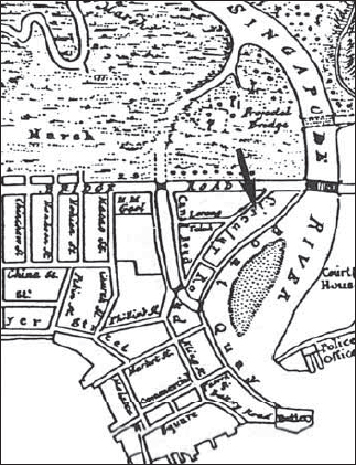
This pier was built between 1927 and 1933 and was named after Sir Hugh Clifford, Governor of the Straits Settlements between 1927 and 1929. Before the Tanjong Pagar wharves were built in the 1850s, Johnston’s Pier was the chief landing place. By the 1930s, the pier was worn out and the government decided to build a new one and name it after Sir Clifford. Its opening on 3 June 1933 was boycotted by merchants because they wanted the old name, Johnston’s Pier, reinstated. A.L Johnston was one of the earliest distinguished European residents who came out at about the same time as Raffles. A friend of the latter, Johnston was one of Singapore’s first businessmen and founder of the Chamber of Commerce. He was a popular and well-respected citizen whose business was directly connected in those days with imports and exports to and from Europe, ships’ victualling and supplies. This meant that ships’ captains called frequently on Mr Johnston, who was well-known for his kindness, wisdom and hospitality.
He established his company on the site of Whiteaway’s Building (now Malayan Bank Building) and in 1848 moved to the present Hong Kong and Shanghai Bank site. In order to facilitate the transportation of import and export goods from boats, a pier was built by the company and named after Johnston. The local Malays used to call Johnston Pier “lampu merah”. The Hokkiens called it ang theng beh thow and the Cantonese hoong tang mah thow, both meaning “red lamp harbour”, referring to a red beacon which shone over the pier at night as a warning to ships.
Clifford Pier
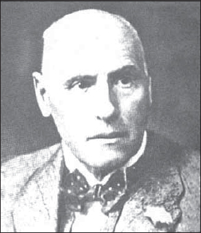
Sir Hugh Clifford was Governor of the Straits Setttlements and author of many short stories on Malaya. Clifford Pier is named after him.
Sir Hugh Clifford, on the other hand, although a highly-regarded man, had no connection with the port of Singapore or its amenities other than the fact that he was the Governor. His activities were largely occupied with his visits to the Malay States and in particular Pahang, the scene of much of his earlier service.
SOURCE: Ramachandran, 1969; Tyers, 1976:241
Clifford Pier
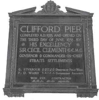
A plague marks the completion and opening of Clifford Pier in June 1933.
Clifford Pier
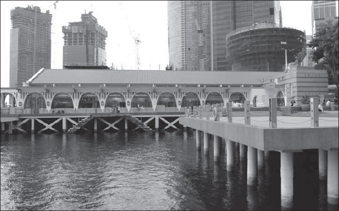
A modern day view of Clifford Pier.
Located in Braddell Heights Estate, this road was officially named in 1951 after an English place name.
SOURCE: MPMCOM, 28 Nov 1951
This street is named after the famous British General in India, Lord Clive. The Hokkiens refer to this street as kam kong ka poh, which means “Kampong Kapor”. This street is in the Kampong Kapor district and has no definite name.
SOURCE: Raja-Singam, 1939:94; Firmstone, 1905:80-81
Club Street got its name from the various Chinese clubs sited on this street. Some say the street got its name after the Chinese Weekly Entertainment Kee Lam Club, which was sited on this street on the top of Ann Siang Street. The club was formed in 1891 and was the leading Straits-Chinese club for several decades. Others believe the street-name is derived from the Chui Lan Teng Club which existed there for more than 90 years. This was the place where wealthy Chinese businessmen would meet for chatting, etc. Another club was the Ee Hoe Hean Club, the most exclusive and prestigious of Chinese clubs in the 1920s, which was founded in 1895 by a group of Hokkien businessmen. The clubhouse was located originally in Duxton Road and shifted in 1910 to Number 38 Club Street. It later moved to Bukit Pasoh Road in 1925. The club had members who were Hokkiens, Teochews, Cantonese and Hakkas. Club Street was predominantly a Hokkien area. Hokkiens living here came from three villages in the Tong Ann county in the Fujian Province. Club Street was known for its sandalwood idols.
This street was known in Chinese as tua man lai, which means “within the big gate”. This is a reference to a big gateway at the entrance of Club Street from the Upper Cross Street junction. The Hokkiens also referred to this street as chui lan teng, meaning “Chu Lan pavilion”. Despite the heavy Chinese clan and business influence along this street, Club Street is also known for the Pondok Peranakan Gelam Club (at 64 Club Street), which was founded in 1932 and housed early settlers from Pulau Bawean (hub of the Bawaeanese community).
SOURCE: Raja-Singam, 1939:94; Firmstone, 1905:80-81; Oral History Department, 1990:40-43; King, 1992:162-63; Samuel, 1991:54
There are two views as to the name of this area. One view holds that the area was named after Jacob Clunis, who in 1847 was both the First Pilot of the New Harbour and a blacksmith at Telok Ayer Street. Cluny is thus a corruption of Clunis. The other view is that during the rubber boom, F.W. Barker was interested in three rubber estates, Lanadron, Ledbrun and Cluny. Cluny, a place name in Scotland, was thus adopted. The minutes of the Municipal Council of 22 May 1856 notes that on the request of W.H. Read, a new road was developed to link Napier and Bukit Timah Roads. Mr Read contributed $20 and gave the materials for metalling the new road – which was then not named.
SOURCE: Raja-Singam, 1939:94; Hale, 2012, personal communication
These names are derived from the Clyde Terrace Market, which was established in 1872 and demolished in 1984, making way for The Gateway – twin office towers currently occupying the space.
Clyde Terrace Market is called te (iron) pasat in Chinese because it is mostly made of iron work. This street is also known as thih pa sat ma ta chu tui bin hang in Hokkien, meaning “the lane opposite the police station near the iron market”.
SOURCE: Ramachandran, 1969:48; Firmstone, 1905:80-81
This street is named after George Drumgold Coleman (1795-1844). Coleman was born in Ireland in 1795. He came to Singapore from Calcutta and Batavia in 1822 and built his house at Number 3 Coleman Street, to his own design, for use as his residence. Coleman was a trained civil architect. He was responsible, as advisor to Raffles, for the draft layout of Singapore in 1822. He planned the centre of the town, created roads, and constructed many fine buildings.
An outstanding example of his work, which survives to this day, is the Armenian Church of St Gregory the Illuminator on Hill Street (built 1835). In 1833 he was appointed the Superintendent of Public Works. He was also the surveyor and overseer of convict labour. Coleman’s house on Number 3 Coleman Street was demolished in December 1965 to make way for the current 21-storey Peninsula Hotel.
Coleman Street
This 1843 Thomson map shows Coleman Street which was named after George Dromgold Coleman who had his house (Number 3) located on the street. The house was demolished in December 1965.
Coleman had earlier leased his house to Monsieur Dutronqouy in 1831, before his departure to England after 15 years of continuous work and 25 years in the East. On Coleman’s unexpected return to Singapore with his bride in November 1843 (he could not settle down in Europe), he took possession of another house of his nearby, standing at 1 & 2 Coleman Street. Thomas Church, councillor from 1837-56 lived in a house which stood at the corner of Coleman Street. The house was built in 1829-30.
In 1840, a brick bridge joining New Bridge Road and Hill Street over the Singapore River was constructed and called Coleman Bridge. In 1865, a new bridge, also called Coleman Bridge, was built; it was made of timber and not well constructed. It cost about $10,000 and was built by the government. In 1886, the present bridge, with its graceful arches, was built.
Coleman died in 1844 in his house in Coleman Street. He was buried in the cemetery at the foot of Bukit Larangan (now Fort Canning Park). The impressive memorial over his mortal remains still stands. The Free Press wrote about him this way: “To his good judgement and untiring energy we owe the great extent of good roads on this island and to his taste and skill as an architect, we are also indebted for many of the elegant bridges, both private and public, which adorn
Coleman Street is known as chin seng chu pi in Hokkien, orides Chin Seng’s house”. The Hokkiens also refer to this street as hiok ni sin chu au, meaning “at the back of Tan Hiok Ni’s new house”. Coleman Bridge is known as yi ma lo khiu (the road at second bridge) in Cantonese.
SOURCE: Hallifax, 1921:323; Hancock, 1955; Hancock, 1986:30; Moore, 1969:166; Edwards & Keys, 1988:493; Ramachandran, 1969:70; Tyers, 1976:106-8; Firmstone, 1905:80-1, 142-3
Coleman Bridge
This bridge built in 1886, was named in honour of G.D. Coleman.
The term Collyer Quay referred originally to the sea wall designed in 1858 and completed sometime between 1864 and 1865, which stretched from Fort Fullerton to Telok Ayer Market. The sea wall was named after Captain (later Colonel) George Chancellor Collyer, the army engineer of the Madras Engineers who was appointed Chief Engineer in 1862 for the fortification of Singapore. His fortifications were apparently useless and became known as Collyer’s Folly. Collyer also did a lot of work in town planning and was connected to the scheme for the Tanjong Pagar Dock. He was a relative of W.R. Collyer, Attorney General in the 1890s.
Collyer Quay
A scene of the old buildings facing Collyer Quay. The Moorish looking building is the former Arcade. These 1930s buildings have all been demolished. Collyer Quay was named after Captain George Chancellor Collyer, a Madras Army Engineer.
In the past, there was no road named Collyer Quay unlike today. All the buildings along the shoreline were directly fronting the sea. The buildings were linked by a continuous verandah along which people walked along the verandah to get from one office to another.
In Cantonese, Collyer Quay was known as hoong tang and in Hokkien, ang theng lor, meaning “red lamp road”, after the red warning beacon lights at Johnston’s Pier (later rebuilt and renamed Clifford Pier). The Chinese also called Collyer Quay tho kho au, meaning “at the back of the godowns”. This serves as a reminder of the original development along the quay, when all the first buildings had faced Commercial Square (later Raffles Place) and only outhouses and sheds were situated along the seashore.
Today, on the sea side of the road stands a monument in tribute to the founders of Singapore. This simple memorial, erected in 1970, is a reminder that immigrants of all races are the greatest contributors to Singapore’s achievement. The foundation stone was laid by Inche Yusof bin Ishak, Singapore’s first President.
SOURCE: Brown, 1936:34; van Cuylenburg, 1982:29; Buckley, 1984:665,686; Edwards & Keys, 1988:453
This was once known as Bain Court.
See Raffles Place; Collyer Quay
This area was developed in 1823-24 on direct orders from Raffles to the Land Allotment Committee in 1823. It was originally a swamp and was reclaimed by cutting down a hill at the point of the Singapore River. It was planted with flowers and trees and named Commercial Square before its name was changed to Raffles Place. The original name of Commercial Square indicates the type of activity that dominated this area from its beginnings.
Wealthy merchants developed residential and office buildings at Commercial Square by Collyer Quay. These buildings came complete with their own private jetties for easy loading and unloading of goods from the quay. In addition to the merchants, several banks also had warehouses beside the river where goods used as collateral for loans were stored.
Commercial Square at Collyer Quay was therefore a popular location for banks, including Banque de L’Indo-Chine and Mercantile Bank of India. Several other banks soon found sites nearby, including Hong Kong and Shanghai Bank, which occupied a permanent location at Collyer Quay, and the Nederlands India Commercial Bank, which was located at Cecil Street. This laid the foundations for today’s financial district centred around Raffles Place. The Telegraph Office was also set up here.
This place is known as tho kho khau in Hokkien, meaning “mouth of the godown”. The Hokkiens also refer to this place as hue hng kak, which means “flower garden square”.
Connaught Drive
Street scene of Connaught Drive around 1922. The road was previously known as New Bridge Esplanade Road and was renamed in 1907 after Prince Arthur’s (The Duke of Connaught) visit in 1906.
SOURCE: Firmstone, 1905:82-3; Singapore Chronicles, 1995
These roads commemorate the international cooperative organisation of former British colonies. Commonwealth Avenue, originally to be called Crown Road, was officially named in 1955.
SOURCE: MPCCOM, 29 Apr 1955, 30 Dec 1955, 30 May 1956
See Sengkang
Connaught Drive was known formerly as New Esplanade Road. It was renamed Connaught Drive by the Municipal Council in 1907 in commemoration of the visit by Queen Victoria’s son, Prince Arthur, the Duke of Connaught and Strathearn (1850-1942), and his wife, Princess Alexandra, to Singapore in 1906. The Princess inaugurated the clock in Victoria Memorial Hall. Singapore’s first pedestrian underpass, built in 1964, links the Queen Elizabeth Walk under Connaught Drive as it approaches Anderson Bridge.
SOURCE: MPMCOM, 1 Mar 1907; Edwards & Keys, 1988:358; Tan-Oehler, 2002:11; Lim 2008:31
See Pulau Satumu
In an 1825 survey of the coastal areas around Singapore by Crawfurd (Resident), Forrester, Lieutenant Jackson and Dr Johnson, Rabbit and Coney (cony is a reference to rabbit) islets were mentioned. The anonymous writer of the Singapore Chronicle article noted on this sighting of the two islets (Rabbit and Coney) that “the whimsical application to these two islets suggests some observations upon the fantastic names which have been given to places in this part of the world; not only by European navigators but by the natives of the country themselves. There is scarcely any sense or meaning in the best of them. Pray, what is the difference between a rabbit and a coney?”
These islands will be developed and linked by bridge with the new town of Punggol which is part of the Punggol 21 Masterplan.
This short street between Tanjong Pagar Road and Tras Street was named in 1925 after Rev J.A. Bethune Cook of the English Presbyterian Christian Mission, which was located on this street. There was some initial hesitation over the naming of this street for fear that Cook Street might be confused with Koek Street, but this was eventually overruled. Cook wrote an account of the people and the results of his missionary work in Singapore, entitled Sunny Singapore, which was published in 1907.
SOURCE: SIT 250/25, 20 May 1925: Unnamed street between Tanjong Pagar Road and Tras Street; MPMCOM, 2 Jun 1925
Cornwall Gardens is said to have got its name because of most of the Cornwall Minstrels, comprising young Chinese, who lived in the area.
SOURCE: Song, 1984:378
See Alexandra Park
This road is within Alexandra Park, a colonial residential park erected between 1935 and 1940, to accommodate British naval and military personnel. Like other roads in the estate named after English or Commonwealth place names, this road is named after an English county.
This street was named after Mr Cornwall, the Attorney-General who retired in 1906. Known as chui long lai in Hokkien, it means “within the spirit depot (district)”. There was formerly a factory manufacturing Chinese spirits near where this road now lies.
SOURCE: Raja-Singam, 1939:95; Firmstone, 1905:82-3
Coronation Road, Empress Road and King’s Road were approved by the Municipal Commissioners as names of three private roads in Choa Lam’s Estate off Bukit Timah Road in 1905. These roads were named after the coronation of King Edward VII (reigned 1901-10).
SOURCE: MPMCOM, 14 Jul 1905; Ramachandran, 1969:35; Ernest Chew, personal communication, 2003
Located in Braddell Heights Estate, this road was officially named in 1950 after an English place name.
SOURCE: MPMCOM, 1 Aug 1950
Originally Cheang Hong Lim Market, Cheang Hong Lim Lane, Cheang Jim Kheng Street and Cheang Jim Chuan Street respectively, these streets off Kim Seng Road were renamed in 1914 as part of an exercise initiated by the Municipal Assessor to minimise confusion and liability to delay in cases of fire due to the similarity of street-names commemorating the well-known opium and spirit farmer and house property owner, Cheang Hong Lim and members of his family. Names after the famous covered market in London were chosen because of the presence of a thriving vegetable market in the vicinity in those days.
SOURCE: MJMFGPSYC, 24 Jul 1914; MPMCOM, 31 Jul 1914
This road is probably named after Sir William Henry Lionel Cox, Chief Justice between 1893 and 1906.
This road is named after Captain J. Craig, a member of the Merchant Service Guild and an officer of the Zetland Lodge, a club. Known as gu chia chui kia in Hokkien, it means “side of Kreta Ayer”.
SOURCE: Lee, 1989:134; Firmstone, 1905:82-3
Together with Avon Road, Lyndhurst Road and Wimborne Road, this was one of the roads named in 1939 after small towns in south England.
SOURCE: MPMCOM, 30 Jun 1939
Formerly known as Lorong A East Coast, this road was officially named in 1934 after the Crane family. The first Crane came to Singapore in the 1820s and became the owner of a large coconut plantation in Geylang and Katong. Thomas Owen Crane (d.1867) spent 35 years in Singapore. He belonged to a big British family involved in auctioneering and land transactions. Together with his brother, he ran the company, Crane Brothers, from 1842 to 1857. In 1836, they managed a 17-acre cotton plantation in Tanjong Katong and in 1850 changed this to coconuts. The plantation still existed during the 1900s as one of the largest coconut plantations in the area, scattered between Amber, Haig, Joo Chiat and Tanjong Katong Roads.
SOURCE: ARSM AED, 1934:3A
Crawford Street was formerly Jalan Rochor in George Coleman’s 1836 Map of Singapore. It was the site of the old Malay kampong which John Turnbull Thomson depicted in an 1846 painting entitled “Campong Rochor”. The street is named after Dr John Crawfurd (1783-1868), the second Resident of Singapore (1823-26) and first President of the Straits Settlements Association, formed in London in 1886, the year of his death. Unfortunately, the spelling of the street name does not match the Resident’s name. He is also the author of History of the Indian Archipelago, among other books. Crawford Street was until 1858 known as Market Street.
Crawford Street
A street scene of Crawford Street around 1915 with a jinricksha in the foreground. Crawford Street was originally known as Market Street and was renamed in 1858 as Crawford Street after the Second Resident (1823–1826) of Singapore, Sir John Crawfurd.
Crawford Road is known as go cho bue in Hokkien, meaning “end of Rochor”. The Hokkiens also refer it as go cho pa sat, which means “Rochor market”.
Crawford Bridge, the first bridge across the Rochor Canal constructed around 1906, was also named after John Crawfurd. It was rebuilt before World War II and is a replica of the Elgin Bridge.
SOURCE: Raja-Singam, 1939:95; Hall-Jones, 1983:50-1 ; The Sunday Times, 16 Mar 1986; Ramachandran, 1969:71; Firmstone, 1905:82-83; Ernest Chew, personal communication, 2003
This is one of the old streets of Singapore and marks the westernmost boundary of the first implementation of Raffles’ Plan of Chinatown. It appears in Coleman’s 1836 Map of Singapore. Prior to the Chinese dominance of this street, it was mainly an Indian residential area. In the 1820s, mainly Indian boatmen lived here and operated shops selling goat’s milk, mutton and herbs. The indigenous place names for this street in the past are indications of the Indian dominance here. The Chinese called this street kiat leng kia ko, or “Kling man’s street” (kling is a derogatory local term for Indians). The Tamils called it paalkadei sadakku, or “street of the milk shops”, while the Malays called it” kampong susu, or “milk village”. Later, as Chinatown expanded beyond Cross Street, the Chinese prevailed. In the 1950s till the late 1970s, Cross Street had numerous Chinese stationery and book shops.
SOURCE: Ramachandran, 1969:10; Edwards & Keys, 1988:454-55; Firmstone, 1905:82-83
This road is named after Dr Croucher, the Principal Civil Medical Officer during Sir Arthur Henderson Young’s governorship (1911-1919).
SOURCE: Raja-Singam, 1939:96
This road was named after J.C. Cuff, an electrician with Eastern Extension Telegraph Company. Cuff was supposed to be a very able lecturer on scientific subjects. He lived here and had a studio erected here in 1894. The street name was officially approved in 1906.
SOURCE: MPMCOM, 30 Nov 1906; Siddique and Puru Shotam, 1982:38
This street is named after Dr J.P. Cumming, who was in Singapore in the mid-nineteenth century. Cumming was the Secretary and Treasurer of the Masonic Zetland Lodge (Free Masons) when it was first established in 1845. This road, together with others in the area (Angus, Boat Quay, Kerr, Solomon) are part of Kampong Malacca. On both sides of Read Bridge (near the Teochew market, cha chun tau and the Clarke Quay area) were the living quarters of Chinese coolies. Cumming Street was also a living area for coolies and had shophouses with its “duckling beds”. Essentially, each room had rows of bunds which each coolie rented for one month. In the 1920s, these duckling beds cost $3 to $10 per month to rent.
The Hokkiens refer to this street as kam kong ma lak kah hi hng koi, meaning “kampong Malacca theatre street”.
SOURCE: Edwards & Keys, 1988:408-09; Firmstone, 1905:84-85; Oral History Department, 1990:31-32
See Emerald Hill Road; Koek Road
This road is named after William Cuppage (1807-72), a postal clerk who rose to become the acting Postmaster General in the 1840s. Cuppage was also Superintendent of Police and Assistant Resident in 1846. Prior to his post office post, Cuppage was a Captain in the 27th Madras Native Infantry. Cuppage first leased Emerald Hill in 1837 and secured a permanent grant in 1845 for his nutmeg plantation (1,250 trees), which failed in the 1860s because of disease. He moved from his residence in Hill Street to Emerald Hill in the early 1850s and lived in the area till his death in 1872. Here he built two houses (Erin Lodge and Fern Cottage) where he lived. His tombstone can still be seen in the cemetery at Fort Canning.
SOURCE: Gretchen, 1984:99; Edwards & Keys, 1988:248-49
This road was named after the Irishman Captain William Andrew Cuscaden (1853-1936), who was Chief Inspector in the Straits Settlements Police in the 1880s, Inspector General of Police from 1905 to 1913, and Chief Inspector of the S.S. Police Force in 1883. Prior to his Singapore posting, Cuscaden served in Africa as Assistant District Commissioner at Lagos. This road was named in 7 June 1921 “with the view of simplifying the house numbering of the town”.
William Cascaden was said to be “a most genial Irishman, very popular socially, and a successful officer, being kind hearted and holding a special affection for his fellow countrymen”. Besides his police positions, William Cuscaden was active in the Boys Scouts and elected president of the Singapore branch from 1912 to 1916. Cuscaden returned to Europe in 1913 and died in 1936. His two sons also worked in Singapore after their father left the colony. One son R.L. Cuscaden was Superintendent of Customs and Excise in Singapore, and the other son, W.L. Cuscaden worked in the Asiatic Petroleum Company.
SOURCE: ARSM ASD, 1921:3A; Braddell, 1921:256; Ramachandran, 1969:19; Lim, 2008:22, 35-36
See Admiralty Road