This lane is named after Bertha da Silva nee Reutens, who lived there.
SOURCE: Braga-Blake and Oehlers, 1992: 94
The word dahan means “branch” in Malay.
This road is named after the dairy farm that used to be located in this area.
Located in the former Singapore Improvement Trust estate at the Old Kallang Airport, these two roads were officially named in 1957.
SOURCE: LO 1362/47, 25 Nov 1947: Renumbering and naming of roads in the City Area (enclosure dated 19 Nov 1957)
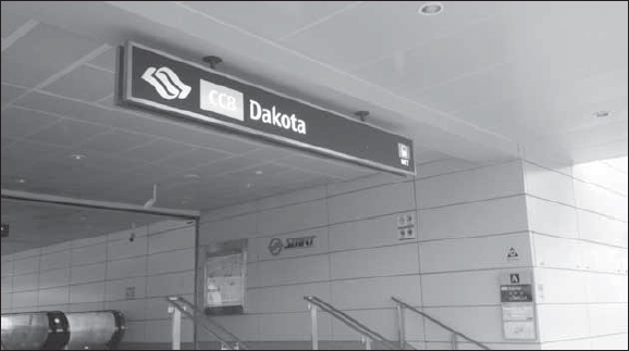
Dakota Crescent
Dakota MRT Station is located on the Circle Line and provides residents of the area with easy access to the rest of the city.
Dalhousie Lane is named after the Marquis of Dalhousie, who was Governor General of India from 1848 to 1856. Dalhousie paid two visits to Singapore.
The memorial obelisk was erected to commemorate the second of Dalhousie’s visits to Singapore in February 1850. The memorial, built to remind succeeding merchants of the benefits of free trade, was funded through a five-dollar subscription fund and was designed by John Turnbull Thomson, the man after whom Singapore’s Thomson Road is named. Originally located at the mouth of the Singapore River, the obelisk’s present site is the third for the memorial. It was moved to its present site after Anderson Bridge was built in 1909.
SOURCE: Edwards & Keys, 1988: 380; Tyers, 1976:70, 71
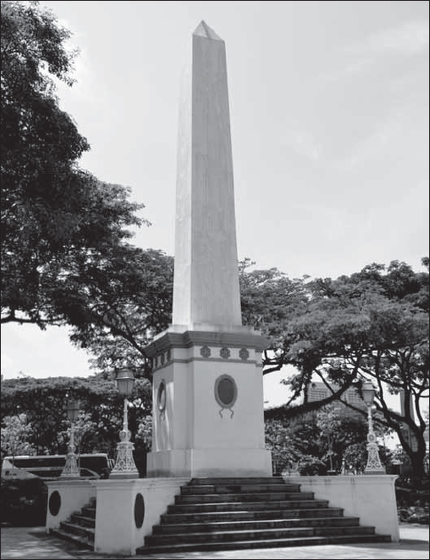
Dalhousie Memorial Obelisk
This memorial was built to commemorate the second visit to Singapore by the Marquis of Dalhousie, Governor General of India from 1848 to 1856.
This street was named in October 1866 after Dr Sir José d’Almeida Carvalho E Silva (1784-1850), who was born in Macao and came to Singapore in December 1825. He had 15 children. His medical practice was sited at Raffles Place (where the former Mercantile Bank was located). He was very keen on agriculture and was one of the founding members of the Agricultural and Horticultural Society in 1937. In 1842, he was appointed Consul General to the Straits Settlements and was knighted by the Queen of Portugal and later by the King of Spain. Dr d’Almeida also owned a mercantile firm, José d’Almeida & Sons. His youngest son, José d’Almeida (1812-94), lived in the Balmoral Road area. Sir Jose is buried in Fort Canning together with nine other members of his family.
D’Almeida Street is known in Chinese as tho kho le long kwan, meaning “the auction rooms by the godowns”. The auction rooms in question refer to Powell and Crane’s auction rooms.
SOURCE: Braga-Blake and Oehlers, 1992: 94; Firmstone, 1905:84-85; Teixeira, 1963 Vol. III:287-308
Dalvey Estate derives its name from the residence “Dalvey” owned by A.L. Johnston and Company in 1868. In 1923, the Municipal Commissioners decided to name the road leading from Dalvey Road to Bukit Timah, Dalvey Estate. This was again ratified in 1941 after the road was repaired by the owner.
SOURCE: MMCI, 31 Mar 1941; MPMCOM, 25 Apr 1941
This road is named after J.E.G. Davidson, the first British Resident of Selangor in 1875. Davidson, a lawyer, initiated the legal firm Woods and Davidson, which later became Rodyk and Davidson.
SOURCE: Raja-Singam, 1939:97
See also Mount Rosie Road/Terrace; Simon Road; Upper Serangoon Road; Punggol
De Souza Street is named after a Eurasian, Manoel de Souza (1816-89), who lived in Malacca during the Dutch period before moving to Singapore. In Singapore, he became a successful merchant, especially in trade with Cochin China, and was also a large landowner. One of his daughters, Rosie (short for Rosalie) married Sohst, a long-term German resident who in the 1890s named his residence (Mount Rosie) after her.
The brothers Manoel Francisco and Tertuliano Jorge de Souza formed the company, Aitken, de Souza and Company, a ship chandelling firm which had a short pier at the foot of the current Prince Street, called De Souza Pier. Manoel de Souza also owned a house, Green Valley, in Cavanagh Road sometime in 1877 and also much of the land bordered by De Souza Street. His brother, Tertuliano had a son, Dr Francis de Souza who won a Queen’s scholarship while at St Joseph’s Institution. His son, Dr Basil Noel de Souza (1903-62) also became a doctor and married Rosalind Choy. They lived in Ponggol and had a famous rambutan estate, the De Souza Farm producing seedless rambutans and unique yellow rambutans. Dr Basil de Souza’s son, Gerald (1946- ) was one of the pioneers of the Ponggol Point’s boatel business – he had the biggest boat storage facility and large sea food restaurant.
De Souza Street is known as lam in tang tho kho kak thau in Hokkien, meaning “blue funnel godown corner”. Mansfield & Company’s godown is at the corner of this street.
SOURCE: Carlos, 1921:367; Buckley, 1984:732; Braga-Blake and Oehlers, 1992: 94; Firmstone, 1905:84-85; de Souza, 2012, personal communication
Located off Yio Chu Kang Road, this road name was officially assigned in 1972. Like other roads in the vicinity named after the begonia or the mimosa, the road is named after a tree, in this case a local variety which bears bright scarlet flowers.
SOURCE: IRSD, 11 Jan 1972, MC 70, VII, Enc. No. 152
See Patani Street; Siak Street
Originally located in the Tanjong Pagar area, this street was named after the port of Deli in Sumatra, which exported pepper. It was likely that the Arab merchants who owned land in this area had trade with Deli. The name is also in accord with other roads in the vicinity that were named after places in the Malay world, as seen in Patani Street, Siak Street and Rambau Street. Deli Street was taken over as part of the development of the container port in Tanjong Pagar.
SOURCE: Lee, 1989:135
See Brahmaputra Road
This is one among several roads within the Havelock Road Singapore Improvement Trust estate either named after or in connection with major rivers of the Indian subcontinent in 1952.
Delta Road is known as o kio to the Hokkiens, which means “the black bridge”. This name is also given by Hokkiens to part of Balestier Road.
SOURCE: SIT 1068/51, 25 Oct 1951: Naming of roads within Havelock Road Estate; Firmstone, 1905:84-5
Dempsey Road was named after Lieutenant-General Sir Miles Dempsey, GOC Malaya Command, 1945. Before it became a British military camp, it was a nutmeg plantation. The British colonial government bought over the nutmeg plantation in the area from Whampoa Hoo Ah Kay in May 1860 for 25,000 Spanish dollars. The nutmeg plantation, known as Mount Harriet, was owned by both Colonial Treasurer William Willans and Whampoa. Due to a blight in 1857, the nutmeg plantation ceased business that year. Captain George Collyer was tasked with strengthening the British defences and decided that the 213-acre Tanglin area (Dempsey Road area) would be the site of the Tanglin Barracks and General Headquarters of the Far East British Forces. With the British withdrawal in 1971, the Singapore Ministry of Defence (MINDEF) and the Central Manpower Base (CMPB) moved in. When they moved out in the 1990s, the area was converted into a lifestyle, fine dining and retail area.
SOURCE: Chan, Rachel, Singapore Infopedia, National Library; Thompson, 2012, personal communication
This road, which led to the New Police Barracks in the Thomson Road vicinity, was officially named in 1929 after G.C. Denham, the Inspector General of Police in the 1920s.
SOURCE: SIT 889/29, 14 Jun 1929: Suggesting that names be given to the two roads leading to the New Police Barracks and Mount Pleasant (off Thomson Road)
See Bristol Road
This road is named after Andre Filipe Desker (1826-98), who was born in Malacca and moved to Singapore in the 1840s. He was the son of Felipe Desker and Miguelina Sekelches, both from Malacca. Andre married in Singapore to Esmeralda Bruyns (d.1890) in 1853 and they had 13 children, born between 1854 and 1880. Most of Andre Desker’s children were married in St Joseph’s Church, where they were active. Andre better known as Henry Desker is the great grandfather of the well-known diplomat Barry Desker, who is the Dean of the S. Rajaratnam School of International Studies (RSIS).
The roots of the Desker name remain unclear. It probably was a Portuguese name that got Anglicized over the years; up to the late eighteenth century it was spelt as Desquer. J.F. Conceicao, the former Member of Parliament says the original name was De Sequeira. Given the Dutch colonial rule in Malacca, the name probably was changed because Portuguese Eurasians were not allowed business opportunities under the Dutch protectionist and mercantilist trade policy in pre-1824 Malacca.
Andre Desker was one of the first butchers in Singapore. The Deskers were a Eurasian family whose butchery was located between Veerasamy Road and Norris Road in the 1860s. His butchery was mentioned in an advertisement in The Straits Times in 1865. They also owned property extending between Cuff Road and Sungei Road, inclusive of Rowell Road. Andre Desker lived in the district through which Desker Road now runs. His sheep, imported from Australia, were housed in numerous sheep pens in his compound.
Andre’s first investment in land was around 1865 consisting of a large plot fronting Serangoon Road and extending to the Kallang River Basin – the current Jalan Besar. His house was built there in Jalan Besar as seen from Rowell Road and was demolished just a few years before the Second World War. He also bought land at ten and half mile Changi Road, the site of the ‘Desker’s Plantation’ of tropical local fruits, now known as the Wing Loong Estate. He built six houses in Queen Street in the 1880s and another six houses in Waterloo Street. He also owned five shophouses in Lembu Road and was a well-known philanthropist who donated generously to major Catholic schools and churches.
Andre’s eldest son, Hermogenes (1854-1912) better known as Armenisgild studied in Raffles Institution and was the chief clerk at Tanjong Pagar Dock Company (afterwards the Singapore Harbour Board). Armenisgild married Carolina Hanson in 1877 and moved into a house he built in Waterloo Street. He built another house in Newton Road (known as Syed Ali Road) in 1905 and named it ‘Carolina Villa’ after his wife. In 1907 he built yet another house in Handy Road opposite the Cathay Cinema and called it ‘Villa Hutsu’.
Today, Desker Road is associated with the “flesh trade” of another kind, being synonymous with Singapore’s red light area.
SOURCE: Siddique and Puru Shotam, 1982:40; Braga-Blake and Oehlers, 1992: 94; Ramachandran, 1969:30; Desker, 2012 personal communication; Teixeira, 1963 Vol. lll:350-355
Many of the roads in this vicinity (Dublin, Exeter, Tiverton) are named after English place names. Devonshire Road was formally called Ryan’s Lane and the speculation is that he was related to the Oxley family who owned a lot of land in the area (Oxley Road, Oxley Rise, Oxley Walk, Oxley Gardens).
SOURCE: Lim, 2008:20
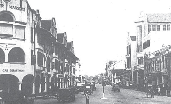
Dhoby Ghaut is derived from the Indian words dhoby, meaning “laundry” and ghaut, meaning “the steps along the bank of a river”. The name stems from the laundry activities that used to take place here from the 1830s onwards. Indian dhobies (Bengali and Madrasi) used to wash their clothes using the water from Stamford Canal (formerly Sungei Bras Basah or Freshwater Stream). The clothes were dried on empty land subsequently occupied by the Ladies Lawn Tennis Club, now occupied by the triangular-shaped park opposite Cathay cinema. About five acres large, this used to be called Dhoby Green. In the past, the whole area was associated with laundry activities. Hence, Queen Street in Tamil was vannan teruvu or “street of the dhobies” and the Malays called it “kampong dhobi”.
Dhoby Ghaut
A view of Dhoby Ghaut and Orchard Road around the 1930s with the Amber Mansions on the left side of the street.
SOURCE: Raja-Singam, 1939:98; Ramachandran, 1969; Edwards & Keys, 1988:284,286; The Straits Times, 13 Nov 1998
See Bukit Pasoh
This hill was unnamed before 1840, but later came to be known as Dickenson Hill after the Reverend J.T. Dickenson, who ran a missionary school in this area. In the 1846 map of Singapore, a “Missionary Lane” was recorded leading to the hill. Dickenson became assistant master of Raffles Institution in the early 1840s. It was afterwards also known as Bukit Padre, and somewhat later as Bukit Pasoh. However, Dickenson Hill Road, a road that ran next to the jinrikisha station, retained its name, which was later officially confirmed in 1922.
SOURCE: ARSM ASD, 1922:4A; Buckley, 1984:346; Lim, 2008:29
This road is named after Sir John Federick Dickson, who was Colonial Secretary and later Administrator of the Straits Settlements between governors in 1887 and 1890. Port Dickson in Peninsular Malaysia is also named after him. This road is known as kam kong ka poh in Hokkien, meaning “Kampong Kapor”.
SOURCE: Firmstone, 1905:84-5
See Bristol Road
This was formerly a British military and residential area; hence, many road names in the area are derived from English place names. For example, those in Medway Park off Dover Road include names associated with the southern coastal areas of England, including Folkestone and Maidstone, apart from Dover.
SOURCE: Edwards & Keys, 1988:310
The name Draycott is derived from the name of house (Dray Cott House) of John Anderson. In the 1860s, the Dray Cott House was owned by A. Velge.
SOURCE: Lim, 2009
This road between Killiney and Oxley Roads was formerly part of Dr Thomas Oxley’s huge estate. Though many of the roads in this vicinity (Devonshire, Exeter, Tiverton) are named after English place names, it is thought that Dr Oxley named Dublin Road.
SOURCE: Lim, 2008:119
Duchess Road, a reserve road off Bukit Timah, was officially named in 1949. It was probably named after royalty in accordance with other existing road names, such as Coronation Road, which commemorates King George V’s coronation in 1911. Duchess Avenue was so-named in 1971. Queen’s, Duke’s, Duchess, Prince and Princess of Wales Roads were all named during the 1911 Coronation of King George V. Given that this whole area once belonged to the rich Ceylonese Tamil surveyor, Arumugam Annamalai (Anamalai Avenue; Namly Road, etc) who was also a fervent royalist, the roads (Duke Road, Kings Road, Queens Road, Prince of Wales Road, Princess of Wales Road) in this area that were named after the British royalty would have pleased him. Annamalai died in 1924.
SOURCE: LO 1362/47, 25 Nov 1947: Renumbering and naming of roads in the City Area (enclosure dated 31 May 1949); IRD 19 Nov 1971, MC 70, VII, Enc. No. 149; Ernest Chew, personal communication, 2003; Paul Supramaniam, personal communication
This road name, describing a road off Bukit Timah Road between Queen’s Road and Cluny Road, was chosen in 1928 instead of more “high-sounding” names such as Windsor Road, Buckingham Road and Sandringham Road, which were proposed at that time. Duke’s Road commemorates the coronation of King George V in 1911.
SOURCE: SIT 503/28, 2 Feb 1928: Suggesting that a name should be given to the Reserve Road off Bukit Timah Road; Ramachandran, 1969:35
See Chiku Road
Duku Road was formerly known as Lorong D East Coast. It was renamed in 1934 after the duku, a local fruit. Several other streets in the area are also named after Malayan fruits. Duku Lane and Duku Place are offshoots of Duku Road named in 1952.
SOURCE: ARSM AED, 1934:3A; MPMCOM, 31 Mar 1952
This road, which lies in Princess Estate, was officially named in 1955.
SOURCE: MPMCOM, 30 Dec 1955
Dunearn Road is named after Dunearn House, a huge mansion that was later converted into Oldham Hall Boarding School. The origins of the word Dunearn are not known. Originally a new road parallel to the railway running from Chancery Lane to the Municipal Boundary, the road was officially named in 1928.
SOURCE: MPMCOM, 2 Oct 1928; Raja-Singam, 1939:98-9
Originally known as Rangasamy Road (before 1870), this street was named after Colonel Samuel Dunlop, Inspector General of Police in the Straits Settlements in the 1875 and member of the Municipal Comission in 1887.
Another view holds that the street was named after A.E. Dunlop, who was secretary and an active member of the Race Course Committee in the Serangoon area. He was one of the colony’s distinguished citizens in the 1840s.
A distinguishing landmark of this street is the Abdul Gaffoor Mosque, a designated national monument. It has two annexes, the earlier of which was built in 1846, and another bigger one built in 1859. This street is known as kam kong ka poh hua (or tua) koi in Hokkien, meaning “Kampong Kapor cross (or big) street”. This is perhaps the biggest street in what is known as Kampong Kapor.
SOURCE: Raja-Singam, 1939:99; Siddique and Puru Shotam, 1982:21, 32; Firmstone, 1905:86-87; The Straits Times, 3 Jan 1998
Dunman Road was named after the Police Magistrate and Commissioner, Thomas Dunman (1814-87). Before assuming the police post he was an assistant in Messrs Martin Dyce & Company. Dunman was a well-liked person and is credited for giving security to households in Singapore by raising and training an efficient police force. He lived in the area named after him on a 400-acre coconut plantation in Tanjong Katong in the 1870s.
There were also other places named after him in the nineteenth century. Dunman Corner referred to the piece of land on the north eastern corner of Bras Basah Road and Victoria Street. Hong Lim Green was formerly named after Dunman (Dunman Green) because he was responsible for filling up the former swamp area, which was opposite the Police Station and Magistrate’s Court in South Bridge Road (now the site of One George Street).
SOURCE: Buckley, 1984:397
See Bristol Road
This road, which leads from Dorset Road into the Kampong Java estate, was officially named in 1952 on the completion of the estate by the Singapore Improvement Trust (SIT). It was so-named in accordance with the desire of the SIT Estate Committee to name roads in this vicinity after “counties and towns in England”. Already there were several roads in the vicinity named after English counties and towns, dating from 1921.
SOURCE: SIT 223/4/50, 2 Sep 1950: Kampong Java – 1959 Programme
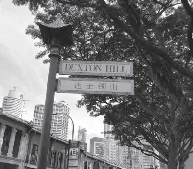
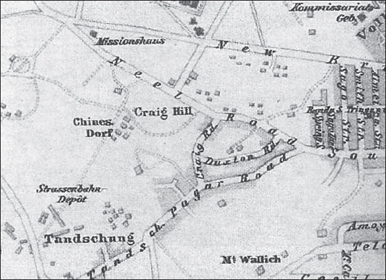
Duxton Hill was formerly owned by Charles Ryan. Charles Ryan was Singapore’s first Post Master but his occupation was recorded as a “store-keeper” in the Resident’s Report of 1824. The hill was named after him because he owned the land in the area and sold his estate to Hugh Syme when he left Singapore in 1827.
Hugh Syme renamed the area Duxton, but there is no evidence of why the name was chosen. It is likely that the Road was named after Hugh Syme’s two houses called ‘Duxton’ and ‘Craig Hill’ which are indicated in the 1840 Maps. Despite the fact that the 1823 Raffles Plan segregated the native Asian population in the area south of the Singapore River and the White population in the area north of the Singapore River, Charles Ryan’s land purchase on the south side of the River was an interesting aberration in dominant practices of ethnic segregation in early Singapore’s history.
Dr J.W. Montgomerie (1797-1856), who first arrived in Singapore in 1819 and became an Assistant Surgeon in the service of the Government, bought over the 32-acre Duxton Estate in 1836. This area sits on 13 ha of nutmeg plantation (1,800 trees). After Montgomerie’s death, the property was sold at an auction in 1856 and fragmented into building lots. The area is, however, still called Duxton Hill and Duxton Road.
Duxton Road was also popularly known by the Cantonese as jinricksha place (and sometimes Kampong Ah Lai) because of the many rickshaw pullers who parked their vehicles there at the close of day due to the road’s proximity to the rickshaw station. Opium and gambling dens, as well as cheap brothels, used to flourish on Duxton Road and one writer describes it as a slum area and a notoriously vice-ridden environment. The lofty and exquisitely designed shophouses along Duxton Hill used to house rich Straits-Chinese.
Duxton Road was known colloquially as kampong kia nai in Hokkien, meaning “within a small village”. The Chinese residents (surnames of Teo, Ho and Chng) were mainly from Hui Ann County in China. The strong clan ties of the rickshaw pullers that created territorial domains in the street led to a lot of fighting in the area. Whenever the Ho’s, Teo’s and Chng’s in Duxton Road had disputes, the Hui Ann Association was asked to be the mediator.
Duxton Road is known to the Hokkiens as gu chia chui kia, meaning “at the side of Kreta Ayer”.
Duxton Road
Detail of an 1894 map published by F.A. Brockhan showing Craig Hill, Craig and Duxton Roads.
Duxton Hill
The shophouses in the vicinity have been converted to offices, restaurants and bars.
In Duxton Park which extends from New Bridge Road to Yan Kit Swimming Pool, there is a keramat (Malay sacred place, usually a grave site of a holy person) of Sharifah Rogayah.
SOURCE: Buckley, 1984:636; Miksic, 1989:34; Firmstone, 1905:86-7, The Straits Times, 23 Feb 1987, 25 Mar 1991:26; Oral History Department, 1990:37-38; Lowe, Ismail, 1998:25; Hall, 2011 personal communication
Formerly a reserve road off Chancery Hill Road leading to Whitley Road, this road was named in memory of C.V. Dyson, a District Judge in Singapore who was killed in the Mutiny of 1915.
SOURCE: MMCI, 19 Feb 1940; MPMCOM, 1 Mar 1940