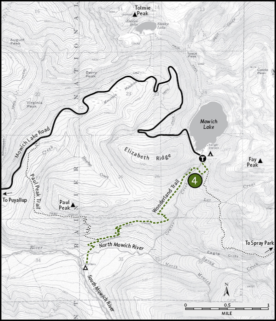
T hough the northwest corner of Mount Rainier National Park boasts a rich history of human development and exploitation, it also offers the most remote and pristine wilderness experience in the park. Throughout the early twentieth century, miners poked and prodded the hills of the upper Carbon and Mowich river basins, searching for everything from gold to coal. But though the miners certainly left a mark, nature is quick to reclaim its own, and most of those early developments have nearly disappeared. Forests covered cabins, rivers washed away old mine sites, and roads eroded back into the hillsides. Today, this region offers hikers long walks on quiet trails. The best chance for solitude in the park can be found here, on the remote trails high above the Carbon River or beyond the shores of Mowich Lake. This is also one of the best places to encounter shy wildlife. Black bears frequent the berry-rich meadows, and mountain goats scamper through the rocky slopes above the subalpine fields.
Maps: Green Trails Mount Rainier West, No. 269; Contact: Carbon River Ranger Station, (360) 829-9639; GPS: N46 56.097, W121 54.409
 Although this trail is within Mount Rainier National Park, limited views of the big mountain are found on this route. In fact, there are few sweeping panoramic views. Fortunately, the forest is a wonderful example of mixed old-growth, with cedar, Douglas fir, hemlock, and a few bigleaf-maples tossed in for good measure. Camp-robber jays, ptarmigans, grouse, hares, red foxes, coyotes, and cougars patrol the area. Best of all, this trail—one of the easiest to reach in the northwest corner of the park—is one of the most lightly used. As a result, hikers can frequently find peaceful solitude on this often-overlooked trail. Walk quietly, and you might encounter some of the beings that do share the trail with you: small birds and other beasts of the forest.
GETTING THERE
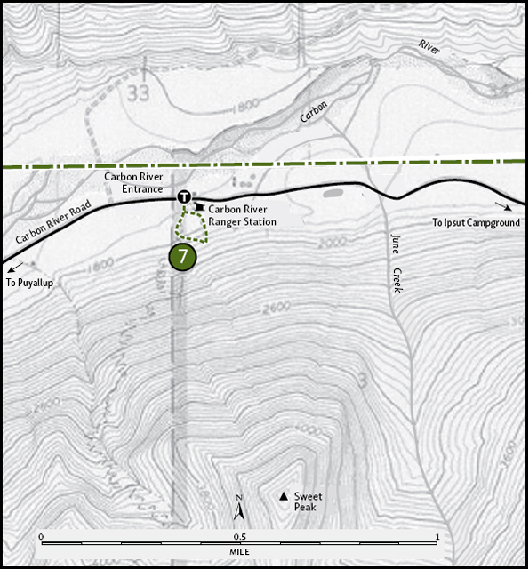
From Puyallup, drive 13 miles east on State Route 410 to Buckley. Turn right (south) onto SR 165 and proceed through Carbonado. Just beyond the Carbon River Gorge bridge, bear right onto Mowich Lake Road. Follow the road about 11 miles to the park boundary. Just 0.5 mile inside the signed boundary, find the trailhead on the right.
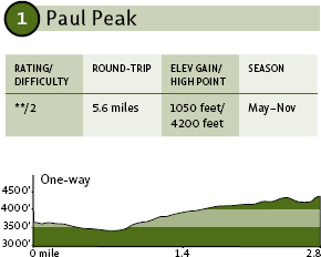
Golden-crowned sparrow on the tip of an alpine fir
ON THE TRAIL
The trail begins with a gradual drop of a couple hundred feet in the first 0.5 mile before the trail crosses the beautiful Meadow Creek at 3450 feet. The bridge over the creek often is visited by small birds that use it as a perch as they flit around the creek, searching for insects to eat. Pause for a moment of quiet reflection at the creekside, and you might hear the twitter of the birds or possibly even see them dipping for aquatic bugs.
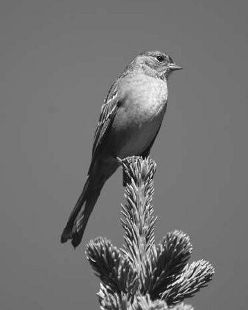
Opening in the forest along the Paul Peak trail down at the South Mowich River
The trail stays fairly level from the creek crossing, following the hillside south another 0.5 mile before curving east along the flank of Paul Peak. As you cross a broad area of blown-down timber on the steep slope, you'll find a grand view of Mount Rainier as well as a sweeping panorama of the South Mowich River drainage. At 2.8 miles (3500 feet), the trail joins the Wonderland Trail. Your best bet for a modest, quiet outing is to turn around here and return the way you came.
EXTENDING YOUR TRIP
If you turn right on the Wonderland Trail, you'll drop into a long set of switchbacks down to the Mowich River in less than 0.5 mile, at about the point where the North and South forks merge. If you turn left onto the Wonderland Trail, you can hike another 3 miles through this wonderful forest before reaching Mowich Lake (Hike 4)—a good option if you can arrange a ride there.
Maps: Green Trails Mount Rainier West, No. 269; Contact: Carbon River Ranger Station, (360) 829-9639; GPS: N46 55.962, W121 51.817
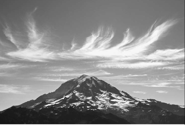
Cirrus clouds over Mount Rainer seen from Tolmie Peak


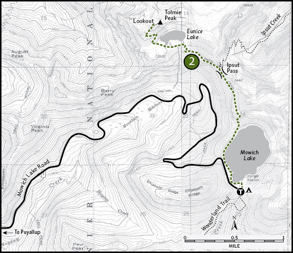
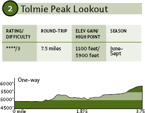
 Bring the kids for this one so they can join everyone else's kids in trooping up to see grand views at a lovely alpine lake, with none of those raspy-looking backpacker types fouling the air along the trail. Tolmie Peak is a day-hiker's special. It's about the right distance, offers the right touch of outdoor magic at its destination, and has been ruled off-limits to overnighters.
GETTING THERE
From Puyallup, drive 13 miles east on State Route 410 to Buckley. Turn right (south) onto SR 165 and proceed through Carbonado. Just beyond the Carbon River Gorge bridge, bear right onto Mowich Lake Road. Follow the road about 17 miles to its end and find the trailhead on the left (north) side of the road, near Mowich Lake.
ON THE TRAIL
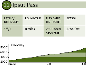
The trail meanders about 1.75 miles to Ipsut Pass (elevation 5100 feet), where more ambitious hikers can continue north along Ipsut Creek to the Carbon River (Hike 11) and the Wonderland Trail.
Stay left and walk just 0.8 mile to Eunice Lake, which offers grand views of Tolmie Peak and its lookout tower, not to mention a little molehill to the east known as Tahoma. Cinch down your knapsack and head on up the trail, climbing steeply another mile to Tolmie Peak, where the panorama is worth every one of the painful steps it took to get here. An old fire lookout cabin still stands atop the ridge knoll west of the true summit of Tolmie Peak. These high, lonesome watch stations have been replaced by satellites and computers, but at times you might still find a volunteer at the lookout cabin. If so, take the time to check out the historic old work room.
Maps: Green Trails Mount Rainier West, No. 269; Contact: Carbon River Ranger Station, (360) 829-9639; GPS: N46 55.962, W121 51.817
Dan hikes through the first openings into Spray Park through autumn colors and opening views.
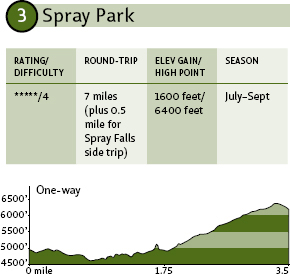
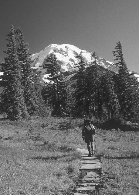
 In many ways, you never recover from your first walk into Spray Park. The trail isn't difficult to follow. It's just difficult to forget. The 3.5-mile walk leads to seemingly endless open meadows of heather and alpine blossoms that tease the nose, ease the mind, and tickle the imagination. The place is a virtual lily factory. The so-called park itself—actually a vast corridor of open meadows interspersed among rocky moraines, lingering snow patches, whistling marmots, and sun-basking hikers—is a wonder to behold in the summer, truly qualifying as one of Rainier's most magnificent day-hike destinations.
GETTING THERE
From Puyallup, drive 13 miles east on State Route 410 to Buckley. Turn right (south) onto SR 165 and proceed through Carbonado. Just beyond the Carbon River Gorge bridge, bear right onto Mowich Lake Road. Follow the road about 17 miles to its end; the trailhead is at the far end of the Mowich Lake Campground.
ON THE TRAIL
Even though the Mowich entrance to Rainier is a lesser-used, backdoor way into the park, this trail also can be (understandably) quite crowded. But Spray Park is a broad enough area, rife with so many hidden pockets of meadow between rock formations, that it's still possible to grab some solitude among the blossoms.
From Mowich Lake, the trail drops quickly (less than 0.1 mile) to a junction with the Wonderland Trail and then climbs gradually for the next 1.7 miles through sun-filled forests. At this point, you'll find a broad side trail on the right leading a short 0.25 mile down to Spray Falls, a worthwhile side trip (seriously, do not skip this side trip).
After your 0.5-mile excursion to the falls, continue climbing as the trail turns steeply upward through a series of switchbacks. At about 2.5 miles from the trailhead, you'll climb out of the switchbacks and move across Grant Creek. The forest opens onto increasingly broad clearings and meadows, providing views of Hessong Rock (6385 feet) to the north and the hulk of Mount Rainier to the southeast.
The trail continues to climb, more gradually now, through broad fields of flowers. Stop anywhere along here—there are endless options for picnic spots with grand views. To find the best views, though, push on to the spine of the rocky ridge separating Spray Park from Seattle Park to the east. Here, at around 3.5 miles out, you'll find a cool rock garden at 6400 feet.
EXTENDING YOUR TRIP
Continue northeast from Spray Park along the Wonderland Trail for 2.5 miles and then southwest on the Ipsut Creek Trail for a 5-mile walk back to the Mowich Lake parking lot. The total mileage for this tough-to-beat loop is about 15.5 miles. Your feet might not be glad you did it, but your soul will.
Maps: Green Trails Mount Rainier West, No. 269; Contact: Carbon River Ranger Station, (360) 829-9639; GPS: N46 55.962, W121 51.817
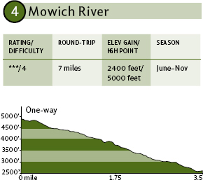
Lake to river, this route descends through lush old forests that provide cool relief from hot summer days. Following the Wonderland Trail south, the trail skirts Crater Creek before traversing the flank of Paul Peak to finally drop into the Mowich River basin, near the junction of the North and South forks of that broad glacial stream. You'll find no views until you stand on the gravel bars in the riverbed, but you will experience forest primeval. Look for wildflowers such as Indian pipe, trillium, and beargrass. There are mushrooms aplenty along the route too—be sure you know which are safe before even thinking about picking them. Black-tailed deer and black bears are commonly seen here, but the most likely critters you'll encounter are grouse—listen for their whomp, whomp, whomps—and squirrels.
GETTING THERE
From Puyallup, drive 13 miles east on State Route 410 to Buckley. Turn right (south) onto SR 165 and proceed through Carbonado. Just beyond the Carbon River Gorge bridge, bear right onto Mowich Lake Road. Follow the road about 17 miles to its end; the trailhead is at the far end of the Mowich Lake Campground.
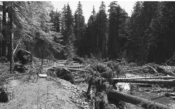
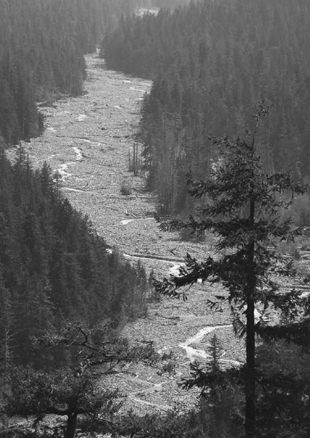
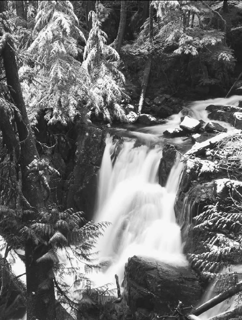
Logs and debris clog the North Mowich River after the November 2006 floods—many choices for logs to use for new footbridges!
ON THE TRAIL
From Mowich Lake, find the Wonderland Trail access path on the south side of the parking lot, and after a short walk through the woods, veer right when you hit the true Wonderland. This leads out across Crater Creek about 0.5 mile from the parking lot, then you descend gradually through the forest, between Crater Creek and Elizabeth Ridge. The trees here are largely hemlock and Douglas fir, some of ancient lineage. Long beards of lichen hang from many of the lower branches, and birds twitter and trill in the undergrowth. If you are here in the twilight hours around dusk or dawn, you might even see bats flying fast and silently through the trees, snatching insects out of the air as if by magic.
About 1.5 miles out, the tail cuts back toward the creek—not quite reaching the tumbling waters, though, before switching back to the west for a long, gentle traverse along the steep slope of Paul Peak. About 0.5 mile later, the trail drops in a series of switchbacks that burn up several hundred feet of elevation before tapering off for a final sidehill run to a trail junction at 3 miles, just above the North Mowich River. Turn left to drop into the river basin and in less than 0.5 mile, cross the river to find the Mowich River backcountry campsite on the peninsula between the North and South forks. Stay and rest in this forest camp before returning the way you came.

EXTENDING YOUR TRIP
You can return to the trail junction above the river in less than 0.5 mile, then follow the Paul Peak Trail (Hike 1) 2.8 miles to the road, if you can arrange a vehicle shuttle.
Maps: Green Trails Mount Rainier West, No. 269; Contact: Carbon River Ranger Station, (360) 829-9639; GPS: N46 59.546, W121 51.034
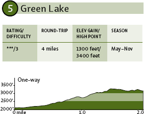
 Think Mount Rainier, and the images that instantly come to mind usually include open meadows, wildflowers, glaciers, and grand views. Green Lake, though, proves there's more to the park than that. This wonderful trail stays with the cool shadows of deep old-growth forests. You'll explore the quiet waters of a cool mountain stream and the deep, dark pool of a forested lake. No sweeping vistas. No alpine meadows. No glaciated peaks. Just rich forest ecosystems and trout-rich waters.
Ranger Falls after a light mid-winter dusting of snow
GETTING THERE
From Puyallup, drive 13 miles east on State Route 410 to Buckley. Turn right (south) onto SR 165. Proceed to the bridge over the Carbon River Gorge and then bear left to Mount Rainier National Park's Carbon River Entrance. Proceed 3 miles to the trailhead on the right.
Note: Due to 2006 flood damage, it may be necessary to walk the road from the point of the first damage, just inside the park boundary. Please contact the park service for current information prior to your hike.
As close as you can get to Chenius Falls when floods have taken the footbridge out—always check if the bridges are in!
ON THE TRAIL
From the trailhead, it's an easy, 1-mile-long walk through spectacular old-growth forest to spellbinding Ranger Creek Falls, just off the main trail. Stop and enjoy the pounding waters of the falls before moving back up the forest path as it continues upward on a gradual incline toward Green Lake. About 1 mile past the falls, you'll suddenly find yourself stepping out of forest onto the lakeshore. The trees push right down to the water's edge, and frequently they fall into the deep waters, taking the woods right into the lake.
Enjoy it with the kids—they'll relish a cool (!) dip in the lake on a hot summer day. Just be sure to warn them of underwater logs so they don't dive and get tangled in the submerged branches.
The trail faces perennial threats due to the frequent flooding damage to the Carbon River Road. That road provides access to the trailhead, and because this quiet one-way trail lacks the high-profile grandeur of some other area trails, the Carbon River Road frequently is last to be repaired. The trail today remains in good form, but hikers need to keep using it—even during those periodic road closures (at these times, a short mountain bike ride gets to the trailhead with no trouble), to ensure its longevity.

Maps: Green Trails Mount Rainier West, No. 269; Contact: Carbon River Ranger Station, (360) 829-9639; GPS: N46 59.437, W121 50.640
Chenuis Creek stair-steps down a series of rocky platforms to form the multitiered Chenuis Falls. The short trail leading to the noisy cascade is perfect for families or for visiting relatives who want to experience the diverse beauty of Mount Rainier National Park without excessive effort. The short hike can be combined with one or more of the other short routes in the Carbon River area to create a day of adventure without overtiring anyone.
GETTING THERE
From Puyallup, drive 13 miles east on State Route 410 to Buckley. Turn right (south) onto SR 165. Proceed to the bridge over the Carbon River Gorge and then bear left to Mount Rainier National Park's Carbon River Entrance. Proceed 3.5 miles to the trailhead on the left.
Note: Due to 2006 flood damage, it may be necessary to walk the road from the point of the first damage, just inside the park boundary. Please contact the park service for current information prior to your hike.
ON THE TRAIL
From the parking area along the Carbon River Road, follow the trail as it drops 50 feet in less than 0.25 mile to the banks of the river itself. You then climb onto a footbridge and trudge across the churning waters before climbing away from the Carbon River. The trail, well shaded by cedars and maples, angles into the Chenuis Creek valley and, at about 0.5 mile from the trailhead, ends at the falls themselves. The crystal-clear water tumbling down the rocky ledges is a nice change from the milky waters of the silt-rich Carbon. The trail fades into the forest beyond this point and isn't worth trying to follow.
Note that this route potentially is accessible by mid-March, though the footbridge over the Carbon River frequently is damaged by winter floods, and repairs usually aren't completed until late May or June. If you plan to visit in late spring or early summer, call ahead to see if the trail is open.

Maps: Green Trails Mount Rainier West, No. 269; Contact: Carbon River Ranger Station, (360) 829-9639; GPS: N46 58.625, W121 49.892
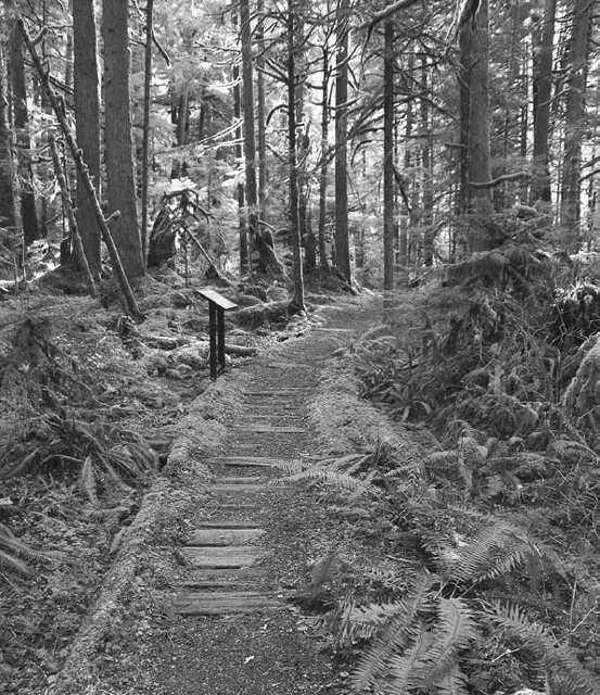
There aren't many examples of temperate rain forest left standing in the southern Cascades. Most of these moss-laden cathedral forests are found on the Olympic Peninsula or along the Coastal Range of Oregon. To be sure, there are old-growth forest stands throughout the Cascades, but very few are of the rain-forest variety. Here is one of those last remnants of the ancient lowland rain forests. Massive cedars and hemlocks fill the valley floor around the floodplain of the Carbon River. A blanket of moss covers the forest floor, while lichens drape from hanging branches and ferns sprout from nearly every surface. Bring the kids and let them explore the micro-ecosystems under the dripping leaves and in the mossy hollows.
GETTING THERE
From Puyallup, drive 13 miles east on State Route 410 to Buckley. Turn right (south) onto SR 165. Proceed to the bridge over the Carbon River Gorge and then bear left to Mount Rainier National Park's Carbon River Entrance. Find the trailhead parking area just inside the park boundary.
Moss-lined trail is the norm along the Carbon Rainforest Loop.
ON THE TRAIL
This self-guided nature trail is a wonderful place to bring the kids. They'll marvel at the tree frogs and lizards that thrive in this damp forest. Bring your binoculars, too, so you can examine the birds that dart through the trees—hunting the same bugs that are being pursued by those amphibians and reptiles (and some of the birds will be hunting those amphibians and reptiles, too).
The trail loops 0.5 mile through the marshy forest, with signage spaced throughout to help educate and entertain forest visitors. Combine this walk with the Chenuis Falls hike if you need more mileage to fully stretch your legs.
Maps: Green Trails Mount Rainier West, No. 269; Contact: Carbon River Ranger Station, (360) 829-9639; GPS: N46 58.625, W121 49.892
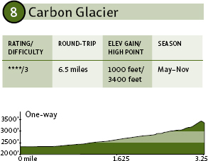
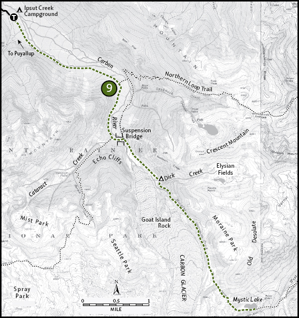
Though the trail is lovely, it's not exactly a thrill—not until you reach the end of the route. There, you'll find yourself swinging on a cable suspension bridge and cooling your heels on an actual glacier. Getting to those highlights, you'll trek along an old miners' road paralleling the Carbon River upstream. This frothy river boasts some serious white water, but it's not because of the rapids (which are generally small and not too frothy). Rather, the whiteness of the water comes from all the powder-fine silt ground up by the moving glacier. This water, known as “glacier milk,” is deathly cold (remember, it's melted glacier ice from just a few miles upstream), so regardless of the heat, steer clear of the river itself.
GETTING THERE
From Puyallup, drive 13 miles east on State Route 410 to Buckley. Turn right (south) onto SR 165. Proceed to the bridge over the Carbon River Gorge and then bear left to Mount Rainier National Park's Carbon River Entrance. Proceed 5 miles to the trailhead at the road's end at Ipsut Creek Campground.
Note: Due to 2006 flood damage, it may be necessary to walk the road from the point of the first damage, just inside the park boundary. Please contact the park service for current information prior to your hike.
ON THE TRAIL
The trail follows an old road built by early twentieth-century miners up the south bank of the Carbon River. The broad trail leads gradually upward 2 miles from Ipsut Creek Campground to a junction with the Northern Loop Trail. This side trail drops off the left side of the main trail, into the river channel. Trail crews replace or realign a series of precarious footlogs and narrow bridges each season as the braided river shifts each year.
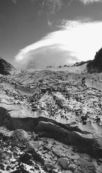
A lenticular cloud towers over Mount Rainier above the Carbon Glacier.
Don't worry about those crossings, though, as our trail continues south along the bank of the Carbon. In another mile, you encounter another fork in the trail. To the right, the trail climbs up the Cataract Creek valley (Hike 12). Take the trail to the left, which rolls up onto a narrow bridge suspended over the Carbon. Thick steel cables hold the bridge deck suspended over the rushing ice water, but the long span is still a bouncing adventure. The bridge is well anchored, however, so cross in confidence. Be sure to stop midbridge, however, to look upstream to the stark face of the Carbon Glacier.
Once safely across, turn right and follow the moraine steeply upward to an excellent viewpoint of the glacier, the lowest-elevation glacier in the Lower 48 states and one of the more melt-resistant ice fingers on Rainier. Most people stop here at about 3.25 miles; the trail beyond shows why, as it gets steep, rocky, and downright ornery for approximately the next mile up to Dick Creek Camp (see Hike 9).
THE BEAR ESSENTIALS
Usually a bear encounter will involve only catching a glimpse of the bear's behind. But occasionally the bruin may actually want to get a look at you. In very rare cases, a bear may act aggressively. If you did everything right to minimize the odds of an encounter with an aggressive bear (see “Bear in Mind” in the introduction) and Yogi appears to be agitated, heed the following advice:
• Respect a bear's need for personal space. If you see a bear in the distance, make a wide detour around it, or if that's not possible (i.e., if the trail leads close to the bear), leave the area.
• If you encounter a bear at close range, remain calm. Do not run, as this may trigger a predator-prey reaction from the bear.
• Talk in a low, calm manner to the bear to help identify yourself as a human.
• Hold your arms out from your body, and if you're wearing a jacket, open up the front well out past your sides so you appear to be as big as possible.
• Don't stare directly at the bear—the bear may interpret this as a direct threat or challenge. Watch the animal without making direct eye-to-eye contact.
• Slowly move upwind of the bear if you can do so without crowding the bear. The bear's strongest sense is its sense of smell, and if it can sniff you and identify you as human, it may retreat.
• Know how to interpret bear actions. A nervous bear will often rumble in its chest, clack its teeth, and “pop” its jaw. It may paw the ground and swing its head violently side to side. If the bear does this, watch it closely (without staring directly at it). Continue to speak low and calmly.
• A bear may bluff-charge—run at you but stop well before reaching you—to try to intimidate you. Resist the urgent desire to run from this charge, as that would turn the bluff into a real charge, and you will not be able to outrun the bear: black bears can run at speeds of up to 35 miles per hour through log-strewn forests.
• If you surprise a black bear and it does charge from close range, lie down and play dead. A surprised bear will leave you once the perceived threat is neutralized. However, if the bear wasn't attacking because it was surprised—if it charges from a long distance, or if it has had a chance to identify you and still attacks—you should fight back. A black bear in this situation is behaving in a predatory manner (as opposed to the defensive attack of a surprised bear) and is looking at you as food. Kick, stab, and punch at the bear. If it knows you will fight back, it may leave you and search for easier prey.
• Carry a 12-ounce (or larger) can of pepper-spray bear deterrent. The spray—a high concentration of oils from hot peppers—should fire out at least 20 or 30 feet in a broad mist. Don't use the spray unless a bear is actually charging and is in range of the spray. Make sure you are not downwind of the spray!
Maps: Green Trails Mount Rainier West, No. 269; Contact: Carbon River Ranger Station, (360) 829-9639; GPS: N46 58.625, W121 49.892
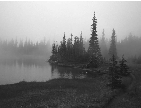
Mystic Lake is said to have been named by early woodsmen who reported seeing unexplained whirlpools in the calm pond. I've never encountered a vortex, but I did notice, during early summer visits, that the lake teems with tadpoles! Regardless of what you find in the dark waters of Mystic Lake, the true mystical experience of this trek is found by gazing out across the broad flower meadows of Moraine Park to the vast expanse of the 3500-foot cliff face of Willis Wall on the north side of Mount Rainier. The stunning experience you'll find in the lake basin and along the fields of Moraine Park make the long trek worth the effort.
Mystic Lake shrouded in fog along the Wonderland Trail
GETTING THERE
From Puyallup, drive 13 miles east on State Route 410 to Buckley. Turn right (south) onto SR 165. Proceed to the bridge over the Carbon River Gorge and then bear left to Mount Rainier National Park's Carbon River Entrance. Proceed 5 miles to the trailhead at the road's end at Ipsut Creek Campground.
Note: Due to 2006 flood damage, it may be necessary to walk the road from the point of the first damage, just inside the park boundary. Please contact the park service for current information prior to your hike.
ON THE TRAIL
The Carbon Glacier Trail, actually part of Rainier's Wonderland Trail, leads gradually upward 2 miles from Ipsut Creek Campground to a junction with the Northern Loop Trail and then turns upward along the Carbon River to a junction with the Spray Park–Seattle Park Trail at about 3 miles. Turn left to cross the spring suspension bridge over the Carbon River, then go right to climb up the lateral moraine kicked out the side of Carbon Glacier. About 0.5 mile from the bridge, take a moment to stop and enjoy the views of this, the lowest-elevation glacier in the Lower 48 states (see Hike 8).
Massive old-growth trees near Ipsut Falls
From this point, the trail gets serious, climbing steeply—ruthlessly—for another mile to Dick Creek backcountry campsite. The climbing slows a bit past Dick Creek, but the route continues steadily upward alongside the glacier—staying well above the glacier itself—another 3 miles. It is in this stretch that you'll enjoy the flower meadows of Moraine Park. The broadest fields are well above the trail on the lower flank of Old Desolate peak, but the trail provides plenty of opportunity to enjoy the flowers at the forest fringe.
At 6.5 miles out, the trail angles away from the glacier basin and climbs, steeply again, into the more open terrain. At 7 miles, you'll find yourself in increasingly expansive meadows, and at 7.8 miles, you'll tiptoe into the Mystic Lake basin.
Maps: Green Trails Mount Rainier West, No. 269; Contact: Carbon River Ranger Station, (360) 829-9639; GPS: N46 58.625, W121 49.892
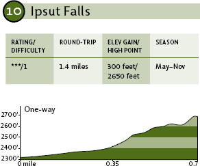
Kids will love this route, which features a short exploration of a lush old-growth forest and leads to a pretty waterfall in a forest dell. The route stays well within the cool shade of the forest, with nice views of the Carbon River as well as Ipsut Creek. This area is frequented by both black-tailed deer and Rocky Mountain elk, so keep an eye open and you might see one or more of the big beasts browsing through the woods or sipping from the waterways.
GETTING THERE
From Puyallup, drive 13 miles east on State Route 410 to Buckley. Turn right (south) onto SR 165. Proceed to the bridge over the Carbon River Gorge and then bear left to Mount Rainier National Park's Carbon River Entrance. Proceed 5 miles to the trailhead at the road's end at Ipsut Creek Campground.
Note: Due to 2006 flood damage, it may be necessary to walk the road from the point of the first damage, just inside the park boundary. Please contact the park service for current information prior to your hike.
ON THE TRAIL
From the trailhead at the campground, follow the Carbon River Trail south into the forest. You'll weave through the trees for more than 0.5 mile, usually well back from the Carbon River, though frequently within hearing distance of the churning water. Deer love this browse-rich section of forest since it provides good cover as well as abundant food and water, so have the kids keep their eyes open for movement in the woods around you, and they might see a stag staring back at you. Or maybe even a delicate doe with fawn. (Blacktails are very small deer in general, and the does can be dainty little ladies.)
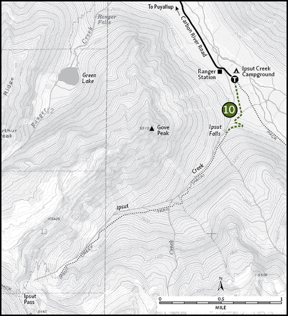
At 0.5 mile out, veer right as the trail angles up the Ipsut Creek Valley, and in just 0.2 mile—just as the trail starts to climb—go right onto a side trail to cut over to the Ipsut Falls viewpoint. Enjoy the spectacle of the churning cascade before heading back.
Maps: Green Trails Mount Rainier West, No. 269; Contact: Carbon River Ranger Station, (360) 829-9639; GPS: N46 58.625, W121 49.892
The State of Alaska is a big, brash place full of larger-than-life people, places, and things. That being the case, you'd think the world's largest Alaska yellow cedar would exist in Alaska, right? Wrong. Alaska may be a land of big mountains, big bears, and big egos, but if you want big trees—especially big Alaska yellow cedars—look no further than Ipsut Creek. Halfway up this valley hike you'll encounter the world's largest Alaska yellow cedar, though this centuries-old tree is just one of many massive trees on this woodland hike. Besides the cathedral forests, you'll also find fantastic views and sprawling meadows on this walk, though these come only at the end.
View down the Ipsut Creek Valley from Ipsut Pass
GETTING THERE
From Puyallup, drive 13 miles east on State Route 410 to Buckley. Turn right (south) onto SR 165. Proceed to the bridge over the Carbon River Gorge and then bear left to Mount Rainier National Park's Carbon River Entrance. Proceed 5 miles to the trailhead at the road's end at Ipsut Creek Campground.
Note: Due to 2006 flood damage, it may be necessary to walk the road from the point of the first damage, just inside the park boundary. Please contact the park service for current information prior to your hike.
ON THE TRAIL
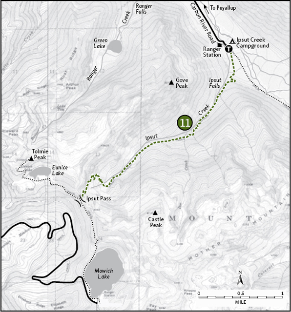
Start up the Carbon River Trail as it weaves through the moss-laden forests adjacent to the Carbon River. At about 0.5 mile, veer right as the trail angles up the Ipsut Creek Valley. Before the trail really starts to climb, you can duck off on a short side track to view Ipsut Falls (Hike 10). Past the falls, the trail climbs moderately through an impressive forest of old-growth Douglas firs and western hemlocks. For the next couple of miles, the trail stays well within earshot, if not eyesight, of Ipsut Creek.
At around 2.7 miles from the trailhead, the forest thins and opens first onto a series of broad clearings, then open hillside meadows. Near the 3-mile mark, the path passes a stand of subalpine trees. These high-elevation trees are smaller than their lowland cousins but no less ancient. Here you'll find the big Alaska yellow cedar.
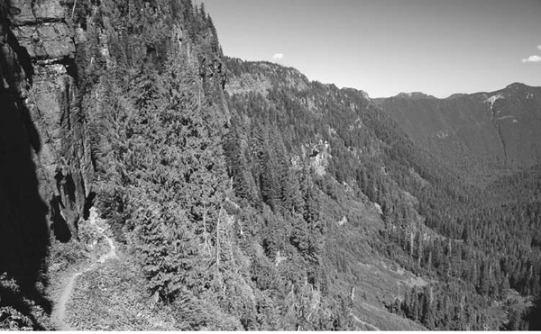
Continuing on past the well-marked world-record tree, the trail runs into a series of steep switchbacks weaving upward through a cliff band to reach Ipsut Pass at 5100 feet elevation. This pass separates the Carbon Valley from the Mowich Valley. From the pass, find limited views of Tolmie Peak and Mother Mountain. Peer down through the trees toward Eunice Lake and Mowich Lake. Then head back the way you came.
EXTENDING YOUR TRIP
You can continue north 2 miles to Eunice Lake and Tolmie Peak Lookout or south 1.75 miles to Mowich Lake (both in Hike 2).
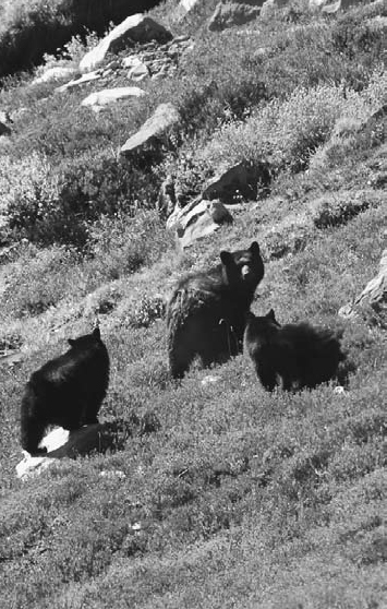
Mama bear and her twin cubs roaming up the slope away from the photographer in Seattle Park
Maps: Green Trails Mount Rainier West, No. 269; Contact: Carbon River Ranger Station, (360) 829-9639; GPS: N46 58.625, W121 49.892
Skyscrapers. Noisy, raucous crowds. Air traffic heavy enough to have you ducking your head at times. About what you'd expect in Seattle, and exactly what you get in Seattle Park—and that's a good thing. The skyscrapers here are towering peaks and jagged rocks. The raucous crowds are colonies of marmots. And the hair-raising air traffic? Gray jays, eagles, ravens, and hawks. The Seattle Park Trail starts in lush old-growth forest and climbs into some of the most spectacular parkland you'll find on the flanks of Mount Rainier. The area is rich in wildlife. Coyotes and bobcats hunt those marmots, as do enormous golden eagles. Mountain goats and black-tailed deer browse those meadows, and so to do lumbering black bears. I've even seen red foxes prancing through the fields, scarfing down mice and voles.
GETTING THERE
From Puyallup, drive 13 miles east on State Route 410 to Buckley. Turn right (south) onto SR 165. Proceed to the bridge over the Carbon River Gorge and then bear left to Mount Rainier National Park's Carbon River Entrance. Proceed 5 miles to the trailhead at the road's end at Ipsut Creek Campground.
Note: Due to 2006 flood damage, it may be necessary to walk the road from the point of the first damage, just inside the park boundary. Please contact the park service for current information prior to your hike.
THIS IS COUGAR COUNTRY
While eastern Washington is clearly cougar country (home to Washington State University), so are the central Cascades. But the cougars that roam these hills don't don crimson and gray! They're wild cats. And they're proliferating. Cougar populations throughout the state have been increasing. No surprise: so have sightings.
Still, cougar encounters are rare. Keep in mind that fewer than twenty fatal cougar attacks have occurred in the United States since the early twentieth century (on the other hand, more than fifty people are killed, on average, by deer each year—most in auto collisions with the deer). You can minimize the already slim chances of having a cougar encounter by doing the following:
• Don't hike or run alone (runners look like fleeing prey to a predator).
• Keep children within sight and close at all times (small humans are more likely prey).
• Avoid dead animals; cougars return to killed prey to continue feeding.
• Keep dogs on leash and under control. A cougar may attack a loose, solitary dog, but a leashed dog next to you makes two foes for the cougar to deal with—and cougars are too smart to take on two aggressive animals at once.
• Be alert to your surroundings.
• Use a walking stick.
Just in case you do have a run-in with this elusive predator, it's important to know how to react. Cougars are curious animals. They may appear threatening when they are only being inquisitive. By making the cougar think you are a bigger, meaner critter than it is, you will be able to avoid an attack (the big cats realize that there is enough easy prey out there that they don't have to mess with something that will fight back). If the cat you encounter acts aggressively, take these steps:
• Don't turn your back on or take your eyes off the cougar.
• Remain standing.
• Throw things, provided you don't have to bend over to pick them up. If you have a water bottle on your belt, chuck it at the cat. Throw your camera, wave your hiking stick, and if the cat gets close enough, whack it hard with your hiking staff (I know of two cases in which women delivered good, hard whacks across the nose of aggressive-acting cougars, and the cats immediately turned tail and ran away).
• Shout loudly.
• Fight back aggressively.
ON THE TRAIL
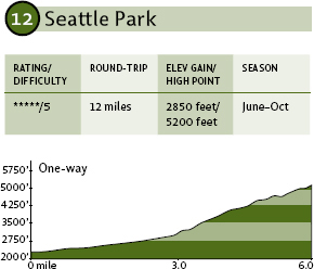
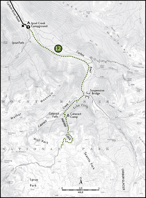
Follow the Carbon River Trail upstream for 3 nearly flat miles. When you reach the suspension bridge crossing the river (see Hike 8), turn right so that, instead of crossing the swinging bridge, you head up the Cataract Creek valley. You now start climbing. As you climb, you'll note the areas of windfalls in the forest—windstorms periodically blast down this valley and have toppled several stands of trees along the way.
After just 1.5 miles of slogging uphill, look for Cataract Camp in a clearing on the left. This backcountry camp is one of the designated stopping points for backpackers. It makes a nice place for a rest for day hikers, too, since you'll find water (from Marmot Creek, a tributary of Cataract Creek) and sunshine after having spent the last few hours hiking under the forest canopy.
Once past Cataract Camp, the trail enters a series of meadows broken by stands of forest. From here on, the higher you go, the bigger and broader the meadow clearings. Finally, at 6 miles, you cross the upper reaches of Marmot Creek and stroll out into the sprawling meadows of lower Seattle Park (5200 feet). Stop here to rest and enjoy the alpine beauty before returning.
EXTENDING YOUR TRIP
If after 6 miles you still have the energy to explore, push on up the trail and, in less than 0.5 mile, you'll reach the transition zone between subalpine and alpine environments, leaving behind the green meadows and entering the world of rock and ice. At 1 mile past Marmot Creek (7 miles from the trailhead), you'll reach the 6400-foot ridge crest that separates Seattle Park from Spray Park (Hike 3).
Maps: Green Trails Mount Rainier West, No. 269; Contact: Carbon River Ranger Station, (360) 829-9639; GPS: N46 58.625, W121 49.892
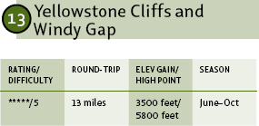
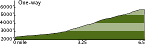
Windy Gap may be the most underrated trail destination in Mount Rainier National Park. Part of the reason for that is the fact that Seattle Park and Spray Park, found just to the southwest, offer equally lovely scenery with less of a workout. It could be because from Windy Gap itself, Mount Rainier can't be seen. Or it could be that the brutal climb to the gap scares most hikers off. Regardless of the reason, the fact remains that the broad meadowlands of Windy Gap and the long, stark face of Yellowstone Cliffs offer stunningly beautiful scenery with a high probability of solitude.
GETTING THERE
From Puyallup, drive 13 miles east on State Route 410 to Buckley. Turn right (south) onto SR 165. Proceed to the bridge over the Carbon River Gorge and then bear left to Mount Rainier National Park's Carbon River Entrance. Proceed 5 miles to the trailhead at the road's end at Ipsut Creek Campground.
Note: Due to 2006 flood damage, it may be necessary to walk the road from the point of the first damage, just inside the park boundary. Please contact the park service for current information prior to your hike.
ON THE TRAIL
Hike up the Carbon River Trail from the east end of the campground, and in just 2 miles look for a side trail to the left. This is the official start of the Northern Loop Trail, but because there is not a true bridge across the river here—just a series of long footlogs that have a tendency to wash out in the spring—hikers might have to push on to the Carbon River suspension bridge at 3 miles to cross the river, then backtrack down the opposite shore to the start of the loop trail (this detour adds about 2 miles to the one-way mileage).
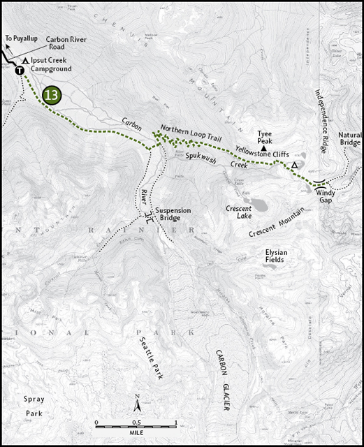
Assuming you can cross the river at the lower point, however, find the trail on the northeastern shore and start a long, steep climb through a seemingly endless series of switchbacks. This punishing climb will tax even the strongest hiker as it gains a whopping 3000 feet in just over 3 miles. The good news is, the climb is through heavy, cool forest most of the way, and as you near the top, the forest opens on broad meadows and windswept ridges.
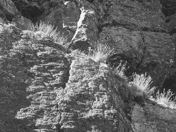
Dried flowers and grasses growing right out of the rocky cliffs
At about 5 miles from the start (via the lower river crossing), you reach Yellowstone Cliffs. The cliffs are a tall wall of yellow-tinged rocks towering over a long, sloping meadowland. Deer and mountain goats share this area, with the goats preferring the rocks and the meadows atop them and the deer favoring the meadows abutting the forests below the cliffs. A fine campsite is nestled in the trees near Spukwush Creek, with good views of the cliffs and the meadows.
Continuing on past the cliffs, the trail keeps climbing, now in the broad meadows, for another 1.5 miles to the U-shaped basin of Windy Gap (at 6.5 miles from the road end). Plant life is sparser here, with just a bit of heather and grasses pushing up through the rocks and around the edges of the many little tarns that dot the gap. A perpetual breeze blows through the gap (hence the name), but there's not much of a view.
If you have the time and inclination, an off-trail scramble is worthwhile here. Climb the rocky slope on the south side of the gap to attain the ridge crest above. Here, you can peer down to the west on the sapphire-blue waters of Crescent Lake and south to the emerald-green plain of the Elysian Fields. Towering above the fields is mighty Mount Rainier.
EXTENDING YOUR TRIP
It's well worth the time to venture another long mile along the Northern Loop Trail and then just over a half-mile northeast on a side trail to a viewpoint of the Natural Bridge, a massive rock arch across a ravine. For an even longer adventure, continue east from here to hike Rainier's Northern Loop, which leads to Grand Park (Hike 14) and then the Fire Creek and Berkeley camps near Sunrise; it then swings back west on the Wonderland Trail over Skyscraper Pass to Granite Creek Park, the Winthrop Glacier, Mystic Lake, and (ultimately) the start at Ipsut Creek Campground. The total loop is about 35 miles and leads through some of the most unspoiled and untrammeled alpine areas of the park. Allow four or five days, but if you've got a week, you'll be glad you took it. Upper portions of this trail are snow-covered until midsummer.